![](/images/other/stat-length.png)
![Trail Walking Entremont-le-Vieux - Le Désert d'Entremont - Photo](https://media.geolcdn.com/t/1900/400/ext.pjpeg?maxdim=2&url=https%3A%2F%2Fstatic1.geolcdn.com%2Fsiteimages%2Fupload%2Ffiles%2F1553511878bg_sport_marche.png)
Le Désert d'Entremont
Phil36
User
![Length](/images/other/stat-length.png)
Length
8.2 km
![Max alt](https://static1.geolcdn.com/siteimages/upload/files/1508320355ic_sort_altitude_max_24dp.png)
Max alt
1213 m
![Uphill gradient](https://static1.geolcdn.com/siteimages/upload/files/1508320355ic_sort_den_pos_24dp.png)
Uphill gradient
384 m
![Km-Effort](/images/other/stat-length.png)
Km-Effort
13.3 km
![Min alt](https://static1.geolcdn.com/siteimages/upload/files/1508320355ic_sort_altitude_min_24dp.png)
Min alt
830 m
![Downhill gradient](https://static1.geolcdn.com/siteimages/upload/files/1508320355ic_sort_den_neg_24dp.png)
Downhill gradient
388 m
![Boucle](https://static1.geolcdn.com/siteimages/upload/files/16400158638029165_repeat_loop_refresh_sync_direction_icon.png)
Boucle
Yes
Creation date :
2018-04-17 23:00:24.989
Updated on :
2018-04-17 23:00:24.989
![Walking](https://static1.geolcdn.com/sitytour/trail-icons/101.png)
2h49
Difficulty : Medium
![Scan this QR Code to open this trail in the SityTrail application](https://capi.geolives.com/qq0zvz2zws4bq2lad0pu/sitytour/trails/931261/qr.png?size=200)
FREE GPS app for hiking
About
Trail Walking of 8.2 km to be discovered at Auvergne-Rhône-Alpes, Savoy, Entremont-le-Vieux. This trail is proposed by Phil36.
Description
Cette petite randonnée dans la Vallée des Entremonts offre une découverte des paysages agricoles dominés par le Mont Outhéran et le Mont granier.
Positioning
Country:
France
Region :
Auvergne-Rhône-Alpes
Department/Province :
Savoy
Municipality :
Entremont-le-Vieux
Location:
Unknown
Start:(Dec)
Start:(UTM)
725411 ; 5037277 (31T) N.
Comments
Trails nearby
![Trail Walking Apremont - Mont Joigny, pte de la Georgat, la Lentille, le GD Carroz - Photo](https://media.geolcdn.com/t/375/260/34a799f3-15e1-4e29-b39c-0c906d59ce42.jpg&format=jpg&maxdim=2)
![Walking Walking](https://static1.geolcdn.com/sitytour/trail-icons/101.png)
Mont Joigny, pte de la Georgat, la Lentille, le GD Carroz
Walking
Easy
(1)
Apremont,
Auvergne-Rhône-Alpes,
Savoy,
France
![](/images/other/stat-length.png)
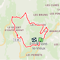
12.7 km | 23 km-effort
4h 3min
![](https://static1.geolcdn.com/siteimages/upload/files/16400158638029165_repeat_loop_refresh_sync_direction_icon.png)
Yes
![Trail Walking Saint-Pierre-d'Entremont - chartreuse varvats fouda blanc pinet - Photo](https://media.geolcdn.com/t/375/260/3ade212f-cb78-41d4-b551-255bd725eded.jpg&format=jpg&maxdim=2)
![Walking Walking](https://static1.geolcdn.com/sitytour/trail-icons/101.png)
chartreuse varvats fouda blanc pinet
Walking
Difficult
(1)
Saint-Pierre-d'Entremont,
Auvergne-Rhône-Alpes,
Savoy,
France
![](/images/other/stat-length.png)
14.4 km | 27 km-effort
5h 27min
![](https://static1.geolcdn.com/siteimages/upload/files/16400158638029165_repeat_loop_refresh_sync_direction_icon.png)
Yes
![Trail Walking Sainte-Marie-du-Mont - Les Belles Ombres - Sangle et Rochers - Sainte Marie du Mont - Photo](https://media.geolcdn.com/t/375/260/ext.jpg?maxdim=2&url=https%3A%2F%2Fservices.sitytrail.com%2FGeolivesWS%2FDownloadMedia.ashx%3FTrailID%3D106447%26Media%3D10957_1.jpg)
![Walking Walking](https://static1.geolcdn.com/sitytour/trail-icons/101.png)
Les Belles Ombres - Sangle et Rochers - Sainte Marie du Mont
Walking
Medium
(1)
Sainte-Marie-du-Mont,
Auvergne-Rhône-Alpes,
Isère,
France
![](/images/other/stat-length.png)
8.6 km | 16.2 km-effort
5h 0min
![](https://static1.geolcdn.com/siteimages/upload/files/16400158638029165_repeat_loop_refresh_sync_direction_icon.png)
Yes
![Trail Walking Entremont-le-Vieux - Le Mont Granier par la cheminée de Tencovaz - Photo](https://media.geolcdn.com/t/375/260/ext.jpg?maxdim=2&url=https%3A%2F%2Fservices.sitytrail.com%2FGeolivesWS%2FDownloadMedia.ashx%3FTrailID%3D103708%26Media%3D6232_1.jpg)
![Walking Walking](https://static1.geolcdn.com/sitytour/trail-icons/101.png)
Le Mont Granier par la cheminée de Tencovaz
Walking
Difficult
(3)
Entremont-le-Vieux,
Auvergne-Rhône-Alpes,
Savoy,
France
![](/images/other/stat-length.png)
9.6 km | 24 km-effort
5h 0min
![](https://static1.geolcdn.com/siteimages/upload/files/16400158638029165_repeat_loop_refresh_sync_direction_icon.png)
Yes
![Trail Snowshoes Saint-Pierre-d'Entremont - La Croix de l'Alpe depuis les Varvats - Photo](https://media.geolcdn.com/t/375/260/ext.jpg?maxdim=2&url=https%3A%2F%2Fservices.sitytrail.com%2FGeolivesWS%2FDownloadMedia.ashx%3FTrailID%3D103120%26Media%3D4867_1.jpg)
![Snowshoes Snowshoes](https://static1.geolcdn.com/sitytour/trail-icons/504.png)
La Croix de l'Alpe depuis les Varvats
Snowshoes
Medium
(1)
Saint-Pierre-d'Entremont,
Auvergne-Rhône-Alpes,
Savoy,
France
![](/images/other/stat-length.png)
12 km | 24 km-effort
5h 0min
![](https://static1.geolcdn.com/siteimages/upload/files/16400158638029165_repeat_loop_refresh_sync_direction_icon.png)
Yes
![Trail Walking Chapareillan - Le Granier 1933m, par les pas de la Porte et de Bellecombe - Photo](https://media.geolcdn.com/t/375/260/ext.jpg?maxdim=2&url=https%3A%2F%2Fservices.sitytrail.com%2FGeolivesWS%2FDownloadMedia.ashx%3FTrailID%3D102833%26Media%3D3997_1.jpg)
![Walking Walking](https://static1.geolcdn.com/sitytour/trail-icons/101.png)
Le Granier 1933m, par les pas de la Porte et de Bellecombe
Walking
Difficult
(1)
Chapareillan,
Auvergne-Rhône-Alpes,
Isère,
France
![](/images/other/stat-length.png)
13.2 km | 30 km-effort
7h 30min
![](https://static1.geolcdn.com/siteimages/upload/files/16400158638029165_repeat_loop_refresh_sync_direction_icon.png)
Yes
![Trail Walking Saint-Pierre-d'Entremont - Roche Veyrand par les Clapiers, 1429m - Photo](https://media.geolcdn.com/t/375/260/ext.jpg?maxdim=2&url=https%3A%2F%2Fservices.sitytrail.com%2FGeolivesWS%2FDownloadMedia.ashx%3FTrailID%3D101734%26Media%3D1981_1.jpg)
![Walking Walking](https://static1.geolcdn.com/sitytour/trail-icons/101.png)
Roche Veyrand par les Clapiers, 1429m
Walking
Difficult
(1)
Saint-Pierre-d'Entremont,
Auvergne-Rhône-Alpes,
Savoy,
France
![](/images/other/stat-length.png)
4.8 km | 14.3 km-effort
4h 10min
![](https://static1.geolcdn.com/siteimages/upload/files/16400158638029165_repeat_loop_refresh_sync_direction_icon.png)
Yes
![Trail Walking Entremont-le-Vieux - Traversée du Mont Outheran 1676m - Photo](https://media.geolcdn.com/t/375/260/ext.jpg?maxdim=2&url=https%3A%2F%2Fservices.sitytrail.com%2FGeolivesWS%2FDownloadMedia.ashx%3FTrailID%3D101647%26Media%3D1855_1.jpg)
![Walking Walking](https://static1.geolcdn.com/sitytour/trail-icons/101.png)
Traversée du Mont Outheran 1676m
Walking
Difficult
(1)
Entremont-le-Vieux,
Auvergne-Rhône-Alpes,
Savoy,
France
![](/images/other/stat-length.png)
9 km | 15.9 km-effort
3h 30min
![](https://static1.geolcdn.com/siteimages/upload/files/16400158638029165_repeat_loop_refresh_sync_direction_icon.png)
Yes
![Trail Road bike Corbel - Entreront - Photo](https://media.geolcdn.com/t/375/260/9b42e589-105e-4d70-99b0-df835d2b48ea.jpg&format=jpg&maxdim=2)
![Road bike Road bike](https://static1.geolcdn.com/sitytour/trail-icons/201.png)
Entreront
Road bike
Very difficult
(1)
Corbel,
Auvergne-Rhône-Alpes,
Savoy,
France
![](/images/other/stat-length.png)
34 km | 49 km-effort
2h 53min
![](https://static1.geolcdn.com/siteimages/upload/files/16400158638029165_repeat_loop_refresh_sync_direction_icon.png)
Yes