Trail Walking Attignat-Oncin - Le Mont Grêle - Photo
 Phil36
Phil36

User

© OpenStreetMap contributors
Length
Length
15.9 km
Max alt
Max alt
1433 m
Uphill gradient
Uphill gradient
931 m
Km-Effort
Km-Effort  
28 km
Min alt
Min alt
599 m
Downhill gradient
Downhill gradient
932 m
Boucle
Boucle
Yes
Creation date :
2018-04-17 23:00:17.013
Updated on :
2018-04-17 23:00:17.013

(0 Reviews)

Walking
Walking
5h00
Difficulty : Difficult

Scan this QR Code to open this trail in the SityTrail application

FREE GPS app for hiking

Logo SityTrail SityTrail

IGN / Geographical institutes

Download SityTrail from the App Store Download SityTrail from Google Play

Logo SityTrail SityTrail World

The world is yours!

Download SityTrail from the App Store Download SityTrail from Google Play Download SityTrail on Huawei AppGallery

About

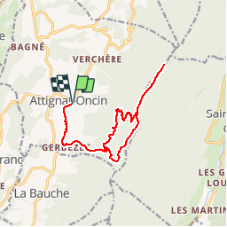
Trail Walking of 15.9 km to be discovered at Auvergne-Rhône-Alpes, Savoy, Attignat-Oncin. This trail is proposed by Phil36.

Description

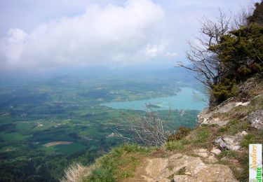
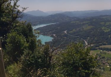
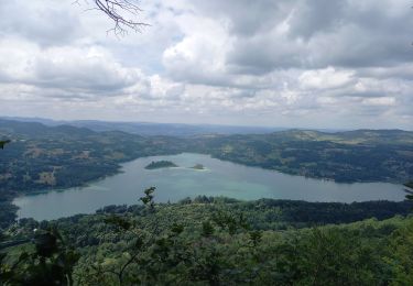
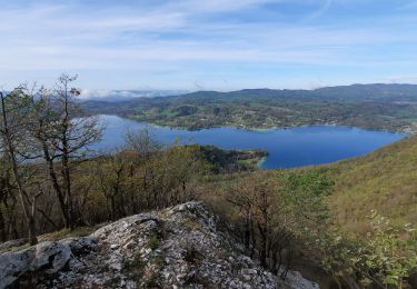
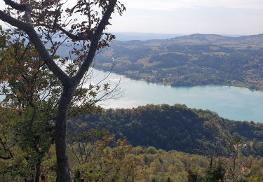
Le Mont grêle (1425m) est situé sur la chaîne de l'Epinequi, géologiquement , appartient au massif du Jura. Cette ascension offre un panorama exceptionnel sur le Lac d'Aiguebelette.

Elevation profile

Positioning

Country:
France
Region :
Auvergne-Rhône-Alpes
Department/Province :
Savoy
Municipality :
Attignat-Oncin
Location:
Unknown
Start:(UTM)
716977 ; 5042951 (31T) N.

Trails nearby

Trail Walking Attignat-Oncin - Le Mont Grelle 1425m, depuis Attignat - Oncin - Photo
Walking
tracegps

Walking

Medium
(3)
Attignat-Oncin, Auvergne-Rhône-Alpes, Savoy, France
9.6 km | 17.6 km-effort
4h 30min
Yes
Trail Walking La Bauche - Ballade vers la Bauche - Photo
Walking
GUIDE
nadd73

Walking

Easy
La Bauche, Auvergne-Rhône-Alpes, Savoy, France
11.7 km | 23 km-effort
6h 19min
Yes
Trail Walking Aiguebelette-le-Lac - Mont grêle  - Photo
Walking
grattounette

Walking

Difficult
(2)
Aiguebelette-le-Lac, Auvergne-Rhône-Alpes, Savoy, France
17.8 km | 32 km-effort
8h 5min
Yes
Trail Walking Aiguebelette-le-Lac - 73 aiguebelette zel - Photo
Walking
GUIDE
randodyssée

Walking

Medium
Aiguebelette-le-Lac, Auvergne-Rhône-Alpes, Savoy, France
14.2 km | 27 km-effort
5h 22min
No
Trail Walking Aiguebelette-le-Lac - Montagne de l'Epine 2.6.24 - Photo
Walking
GUIDE
fredetpascale

Walking

Medium
Aiguebelette-le-Lac, Auvergne-Rhône-Alpes, Savoy, France
6.9 km | 12 km-effort
2h 45min
Yes
Trail Trail La Bauche - Mont Beauvoir  - Photo
Trail
GUIDE
nadd73

Trail

Easy
La Bauche, Auvergne-Rhône-Alpes, Savoy, France
9.2 km | 18.7 km-effort
1h 47min
Yes
Trail Walking Aiguebelette-le-Lac - Mont Grêle  - Photo
Walking
Zasa

Walking

Medium
Aiguebelette-le-Lac, Auvergne-Rhône-Alpes, Savoy, France
16.3 km | 30 km-effort
5h 0min
Yes
Trail Walking Aiguebelette-le-Lac - Belvédère du Rocher du Corbeau - Photo
Walking
GuyVachet

Walking

Difficult
(1)
Aiguebelette-le-Lac, Auvergne-Rhône-Alpes, Savoy, France
5 km | 9.3 km-effort
2h 7min
Yes
Trail Walking Aiguebelette-le-Lac - aiguebelette, col du crucifix - Photo
Walking
francislassauce

Walking

Difficult
Aiguebelette-le-Lac, Auvergne-Rhône-Alpes, Savoy, France
9.8 km | 17.4 km-effort
4h 14min
Yes


Close
My subscriptions