![](/images/other/stat-length.png)
![Trail Walking Beaurepaire - Beaurepaire sentier des Alivettes - Photo](https://media.geolcdn.com/t/1900/400/ext.pjpeg?maxdim=2&url=https%3A%2F%2Fstatic1.geolcdn.com%2Fsiteimages%2Fupload%2Ffiles%2F1553511878bg_sport_marche.png)
Beaurepaire sentier des Alivettes
PhilippeLegault
User
![Length](/images/other/stat-length.png)
Length
15.1 km
![Max alt](https://static1.geolcdn.com/siteimages/upload/files/1508320355ic_sort_altitude_max_24dp.png)
Max alt
126 m
![Uphill gradient](https://static1.geolcdn.com/siteimages/upload/files/1508320355ic_sort_den_pos_24dp.png)
Uphill gradient
112 m
![Km-Effort](/images/other/stat-length.png)
Km-Effort
16.6 km
![Min alt](https://static1.geolcdn.com/siteimages/upload/files/1508320355ic_sort_altitude_min_24dp.png)
Min alt
83 m
![Downhill gradient](https://static1.geolcdn.com/siteimages/upload/files/1508320355ic_sort_den_neg_24dp.png)
Downhill gradient
113 m
![Boucle](https://static1.geolcdn.com/siteimages/upload/files/16400158638029165_repeat_loop_refresh_sync_direction_icon.png)
Boucle
Yes
Creation date :
2018-04-17 21:30:43.789
Updated on :
2018-04-17 21:30:43.789
![Walking](https://static1.geolcdn.com/sitytour/trail-icons/101.png)
4h27
Difficulty : Very easy
![Scan this QR Code to open this trail in the SityTrail application](https://capi.geolives.com/qq0zvz2zws4bq2lad0pu/sitytour/trails/921138/qr.png?size=200)
FREE GPS app for hiking
About
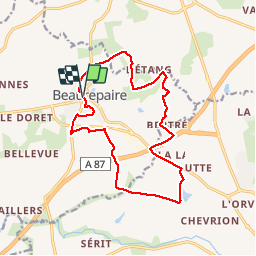
Trail Walking of 15.1 km to be discovered at Pays de la Loire, Vendée, Beaurepaire. This trail is proposed by PhilippeLegault.
Description
Larges chemins et routes dominent pour cette balade parfaitement balisée. À faire plutôt l'hiver par temps calme les chemins sont principalement sur les crêtes, du vent et pas d'ombre.
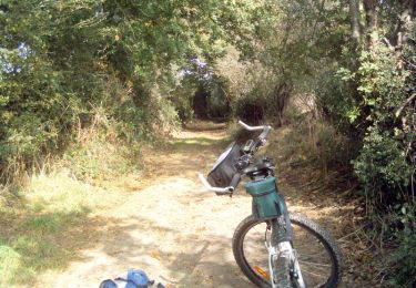
Positioning
Country:
France
Region :
Pays de la Loire
Department/Province :
Vendée
Municipality :
Beaurepaire
Location:
Unknown
Start:(Dec)
Start:(UTM)
645471 ; 5197034 (30T) N.
Comments
Trails nearby
![Trail Mountain bike La Gaubretière - La Gaubretiere - Photo](https://media.geolcdn.com/t/375/260/ext.jpg?maxdim=2&url=https%3A%2F%2Fservices.sitytrail.com%2FGeolivesWS%2FDownloadMedia.ashx%3FTrailID%3D101635%26Media%3D1830_2.jpg)
![Mountain bike Mountain bike](https://static1.geolcdn.com/sitytour/trail-icons/202.png)
La Gaubretiere
Mountain bike
Difficult
La Gaubretière,
Pays de la Loire,
Vendée,
France
![](/images/other/stat-length.png)
25 km | 29 km-effort
1h 45min
![](https://static1.geolcdn.com/siteimages/upload/files/16400158638029165_repeat_loop_refresh_sync_direction_icon.png)
Yes