![](/images/other/stat-length.png)
![Trail Walking Vidauban - Vidauban. Bois d'Astros. - Photo](https://media.geolcdn.com/t/1900/400/ext.pjpeg?maxdim=2&url=https%3A%2F%2Fstatic1.geolcdn.com%2Fsiteimages%2Fupload%2Ffiles%2F1553511878bg_sport_marche.png)
Vidauban. Bois d'Astros.
Sugg
User
![Length](/images/other/stat-length.png)
Length
16 km
![Max alt](https://static1.geolcdn.com/siteimages/upload/files/1508320355ic_sort_altitude_max_24dp.png)
Max alt
213 m
![Uphill gradient](https://static1.geolcdn.com/siteimages/upload/files/1508320355ic_sort_den_pos_24dp.png)
Uphill gradient
372 m
![Km-Effort](/images/other/stat-length.png)
Km-Effort
21 km
![Min alt](https://static1.geolcdn.com/siteimages/upload/files/1508320355ic_sort_altitude_min_24dp.png)
Min alt
57 m
![Downhill gradient](https://static1.geolcdn.com/siteimages/upload/files/1508320355ic_sort_den_neg_24dp.png)
Downhill gradient
376 m
![Boucle](https://static1.geolcdn.com/siteimages/upload/files/16400158638029165_repeat_loop_refresh_sync_direction_icon.png)
Boucle
Yes
Creation date :
2018-04-17 20:58:47.358
Updated on :
2018-04-17 20:58:47.358
![Walking](https://static1.geolcdn.com/sitytour/trail-icons/101.png)
4h34
Difficulty : Easy
![Scan this QR Code to open this trail in the SityTrail application](https://capi.geolives.com/qq0zvz2zws4bq2lad0pu/sitytour/trails/917809/qr.png?size=200)
FREE GPS app for hiking
About
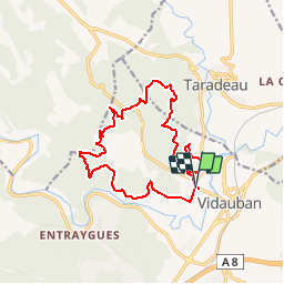
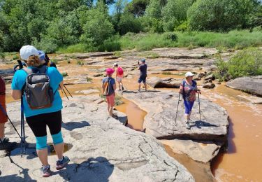
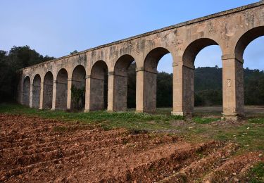
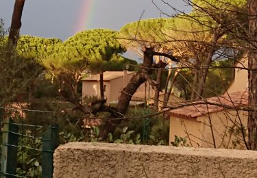
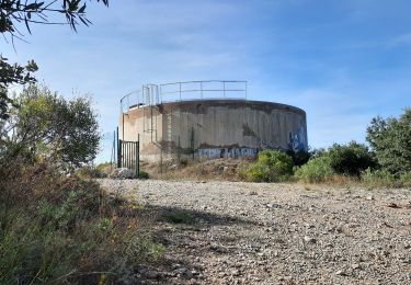
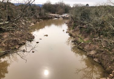
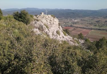
Trail Walking of 16 km to be discovered at Provence-Alpes-Côte d'Azur, Var, Vidauban. This trail is proposed by Sugg.
Description
Prévision de rando pour le 2ème trimestre de RF.
A reconnaître.( voir pour rallonger à l'Ouest au niveau de 155 Fort des Mures en remontant par la Font blanche direct ou par 142 et 161.)
Positioning
Country:
France
Region :
Provence-Alpes-Côte d'Azur
Department/Province :
Var
Municipality :
Vidauban
Location:
Unknown
Start:(Dec)
Start:(UTM)
291244 ; 4811878 (32T) N.
Comments
Trails nearby
![Trail Walking Les Arcs-sur-Argens - LES ARC SUR ARGENS-Fond du Loup-LA bergerie -DRI - Photo](https://media.geolcdn.com/t/375/260/ext.jpg?maxdim=2&url=https%3A%2F%2Fstatic1.geolcdn.com%2Fsiteimages%2Fupload%2Ffiles%2F1553511878bg_sport_marche.png)
![Walking Walking](https://static1.geolcdn.com/sitytour/trail-icons/101.png)
LES ARC SUR ARGENS-Fond du Loup-LA bergerie -DRI
Walking
Difficult
(1)
Les Arcs-sur-Argens,
Provence-Alpes-Côte d'Azur,
Var,
France
![](/images/other/stat-length.png)
10.3 km | 13.4 km-effort
3h 2min
![](https://static1.geolcdn.com/siteimages/upload/files/16400158638029165_repeat_loop_refresh_sync_direction_icon.png)
Yes
![Trail Walking Vidauban - vidauban l'Aille - Photo](https://media.geolcdn.com/t/375/260/ext.jpg?maxdim=2&url=https%3A%2F%2Fstatic1.geolcdn.com%2Fsiteimages%2Fupload%2Ffiles%2F1553511878bg_sport_marche.png)
![Walking Walking](https://static1.geolcdn.com/sitytour/trail-icons/101.png)
vidauban l'Aille
Walking
Medium
(1)
Vidauban,
Provence-Alpes-Côte d'Azur,
Var,
France
![](/images/other/stat-length.png)
13 km | 14.9 km-effort
4h 0min
![](https://static1.geolcdn.com/siteimages/upload/files/16400158638029165_repeat_loop_refresh_sync_direction_icon.png)
Yes
![Trail Cycle Vidauban - Vidauban - Photo](https://media.geolcdn.com/t/375/260/ext.jpg?maxdim=2&url=https%3A%2F%2Fstatic1.geolcdn.com%2Fsiteimages%2Fupload%2Ffiles%2F1524743154velo.jpg)
![Cycle Cycle](https://static1.geolcdn.com/sitytour/trail-icons/200.png)
Vidauban
Cycle
Medium
(1)
Vidauban,
Provence-Alpes-Côte d'Azur,
Var,
France
![](/images/other/stat-length.png)
30 km | 36 km-effort
2h 0min
![](https://static1.geolcdn.com/siteimages/upload/files/16400158638029165_repeat_loop_refresh_sync_direction_icon.png)
No
![Trail Walking Vidauban - z cascade de l'Aille - Photo](https://media.geolcdn.com/t/375/260/d432d975-2eab-4ca0-8630-02f451470ae5.jpg&format=jpg&maxdim=2)
![Walking Walking](https://static1.geolcdn.com/sitytour/trail-icons/101.png)
z cascade de l'Aille
Walking
Easy
Vidauban,
Provence-Alpes-Côte d'Azur,
Var,
France
![](/images/other/stat-length.png)
3.7 km | 4.2 km-effort
1h 26min
![](https://static1.geolcdn.com/siteimages/upload/files/16400158638029165_repeat_loop_refresh_sync_direction_icon.png)
No
![Walking Walking](https://static1.geolcdn.com/sitytour/trail-icons/101.png)
Vidauban - Château d'Astros - Chapelle St Lambert
Walking
Easy
Vidauban,
Provence-Alpes-Côte d'Azur,
Var,
France
![](/images/other/stat-length.png)
14.8 km | 19.2 km-effort
3h 10min
![](https://static1.geolcdn.com/siteimages/upload/files/16400158638029165_repeat_loop_refresh_sync_direction_icon.png)
Yes
![Trail Walking Vidauban - l'aille - Photo](https://media.geolcdn.com/t/375/260/9287b034-3af8-4f5b-8193-2dc1f6e66c96.jpg&format=jpg&maxdim=2)
![Walking Walking](https://static1.geolcdn.com/sitytour/trail-icons/101.png)
l'aille
Walking
Very easy
Vidauban,
Provence-Alpes-Côte d'Azur,
Var,
France
![](/images/other/stat-length.png)
10.6 km | 12.1 km-effort
2h 51min
![](https://static1.geolcdn.com/siteimages/upload/files/16400158638029165_repeat_loop_refresh_sync_direction_icon.png)
Yes
![Trail Walking Taradeau - 20201007 Taradeau les Arcs 3 - Photo](https://media.geolcdn.com/t/375/260/7b25c2d7-226f-481e-9ae2-733559837431.jpg&format=jpg&maxdim=2)
![Walking Walking](https://static1.geolcdn.com/sitytour/trail-icons/101.png)
20201007 Taradeau les Arcs 3
Walking
Medium
Taradeau,
Provence-Alpes-Côte d'Azur,
Var,
France
![](/images/other/stat-length.png)
13.1 km | 17.7 km-effort
6h 1min
![](https://static1.geolcdn.com/siteimages/upload/files/16400158638029165_repeat_loop_refresh_sync_direction_icon.png)
No
![Trail Walking Vidauban - Vidauban - Photo](https://media.geolcdn.com/t/375/260/f619a604-2aa2-45ad-a923-a7ea52409cc6.jpg&format=jpg&maxdim=2)
![Walking Walking](https://static1.geolcdn.com/sitytour/trail-icons/101.png)
Vidauban
Walking
Easy
Vidauban,
Provence-Alpes-Côte d'Azur,
Var,
France
![](/images/other/stat-length.png)
18.2 km | 24 km-effort
4h 6min
![](https://static1.geolcdn.com/siteimages/upload/files/16400158638029165_repeat_loop_refresh_sync_direction_icon.png)
Yes
![Trail Walking Taradeau - taradel - Photo](https://media.geolcdn.com/t/375/260/3746a864-e320-41d3-b9a7-ce8626ddc19e.jpg&format=jpg&maxdim=2)
![Walking Walking](https://static1.geolcdn.com/sitytour/trail-icons/101.png)
taradel
Walking
Very easy
Taradeau,
Provence-Alpes-Côte d'Azur,
Var,
France
![](/images/other/stat-length.png)
4.5 km | 6.4 km-effort
1h 48min
![](https://static1.geolcdn.com/siteimages/upload/files/16400158638029165_repeat_loop_refresh_sync_direction_icon.png)
Yes