![](/images/other/stat-length.png)
Autour de Rosuel
pascalou73
User GUIDE
![Length](/images/other/stat-length.png)
Length
6.1 km
![Max alt](https://static1.geolcdn.com/siteimages/upload/files/1508320355ic_sort_altitude_max_24dp.png)
Max alt
1553 m
![Uphill gradient](https://static1.geolcdn.com/siteimages/upload/files/1508320355ic_sort_den_pos_24dp.png)
Uphill gradient
107 m
![Km-Effort](/images/other/stat-length.png)
Km-Effort
7.5 km
![Min alt](https://static1.geolcdn.com/siteimages/upload/files/1508320355ic_sort_altitude_min_24dp.png)
Min alt
1456 m
![Downhill gradient](https://static1.geolcdn.com/siteimages/upload/files/1508320355ic_sort_den_neg_24dp.png)
Downhill gradient
111 m
![Boucle](https://static1.geolcdn.com/siteimages/upload/files/16400158638029165_repeat_loop_refresh_sync_direction_icon.png)
Boucle
Yes
Creation date :
2018-04-17 20:07:54.999
Updated on :
2018-04-17 20:07:54.999
![Snowshoes](https://static1.geolcdn.com/sitytour/trail-icons/504.png)
2h00
Difficulty : Medium
![Scan this QR Code to open this trail in the SityTrail application](https://capi.geolives.com/qq0zvz2zws4bq2lad0pu/sitytour/trails/913368/qr.png?size=200)
FREE GPS app for hiking
About
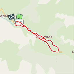
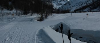
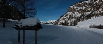
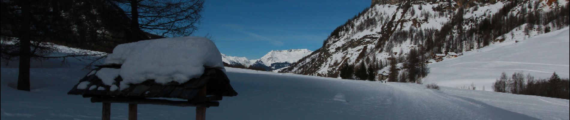
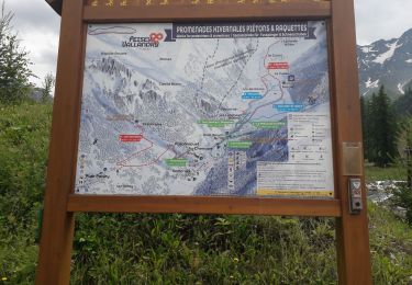
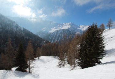
Trail Snowshoes of 6.1 km to be discovered at Auvergne-Rhône-Alpes, Savoy, Peisey-Nancroix. This trail is proposed by pascalou73.
Description
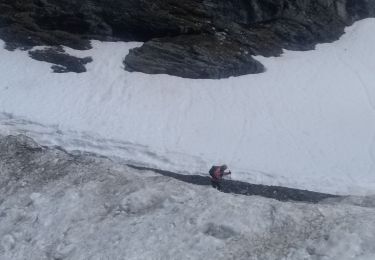
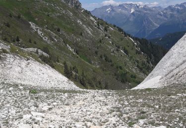
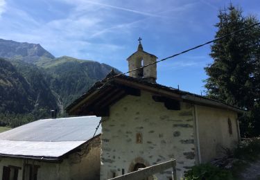
Voilà une belle randonnée qui au départ de camping les planchettes vont vous fair découvrir la vallée et la belle chapelle de Beaupraz . Et vous pourrez voir des chamois et les gypaètes.
Points of interest
Positioning
Country:
France
Region :
Auvergne-Rhône-Alpes
Department/Province :
Savoy
Municipality :
Peisey-Nancroix
Location:
Unknown
Start:(Dec)
Start:(UTM)
326421 ; 5044321 (32T) N.
Comments
Trails nearby
![Trail On foot Peisey-Nancroix - etape 2 - Photo](https://media.geolcdn.com/t/375/260/ext.jpg?maxdim=2&url=https%3A%2F%2Fstatic1.geolcdn.com%2Fsiteimages%2Fupload%2Ffiles%2F1545311037marcheuse_200dpi.jpg)
![On foot On foot](https://static1.geolcdn.com/sitytour/trail-icons/100.png)
etape 2
On foot
Easy
(1)
Peisey-Nancroix,
Auvergne-Rhône-Alpes,
Savoy,
France
![](/images/other/stat-length.png)
9.6 km | 20 km-effort
4h 32min
![](https://static1.geolcdn.com/siteimages/upload/files/16400158638029165_repeat_loop_refresh_sync_direction_icon.png)
No
![Trail Walking Peisey-Nancroix - Roselend- chapelle des Vernettes - Photo](https://media.geolcdn.com/t/375/260/caeb20d8-b45e-419b-83a2-db0814ea618a.jpg&format=jpg&maxdim=2)
![Walking Walking](https://static1.geolcdn.com/sitytour/trail-icons/101.png)
Roselend- chapelle des Vernettes
Walking
Easy
Peisey-Nancroix,
Auvergne-Rhône-Alpes,
Savoy,
France
![](/images/other/stat-length.png)
10.4 km | 16.6 km-effort
3h 18min
![](https://static1.geolcdn.com/siteimages/upload/files/16400158638029165_repeat_loop_refresh_sync_direction_icon.png)
Yes
![Trail Touring skiing Bourg-Saint-Maurice - col des roches vers le Pourri - Photo](https://media.geolcdn.com/t/375/260/1b6a1c42-133a-4e34-bc5c-807990c98faf.jpg&format=jpg&maxdim=2)
![Touring skiing Touring skiing](https://static1.geolcdn.com/sitytour/trail-icons/503.png)
col des roches vers le Pourri
Touring skiing
Difficult
Bourg-Saint-Maurice,
Auvergne-Rhône-Alpes,
Savoy,
France
![](/images/other/stat-length.png)
13.2 km | 29 km-effort
6h 0min
![](https://static1.geolcdn.com/siteimages/upload/files/16400158638029165_repeat_loop_refresh_sync_direction_icon.png)
Yes
![Trail Walking Peisey-Nancroix - la chapelle - Photo](https://media.geolcdn.com/t/375/260/7d1a0a4e-297d-405a-8b27-d2ee45329ab1.jpg&format=jpg&maxdim=2)
![Walking Walking](https://static1.geolcdn.com/sitytour/trail-icons/101.png)
la chapelle
Walking
Very easy
(1)
Peisey-Nancroix,
Auvergne-Rhône-Alpes,
Savoy,
France
![](/images/other/stat-length.png)
4.8 km | 7.3 km-effort
1h 34min
![](https://static1.geolcdn.com/siteimages/upload/files/16400158638029165_repeat_loop_refresh_sync_direction_icon.png)
Yes
![Trail Walking Bourg-Saint-Maurice - arc 1950 col des frettes arc 1800 station internationale - Photo](https://media.geolcdn.com/t/375/260/f895417e-d75f-415c-875d-31cc9f0b4878.jpg&format=jpg&maxdim=2)
![Walking Walking](https://static1.geolcdn.com/sitytour/trail-icons/101.png)
arc 1950 col des frettes arc 1800 station internationale
Walking
Very easy
(1)
Bourg-Saint-Maurice,
Auvergne-Rhône-Alpes,
Savoy,
France
![](/images/other/stat-length.png)
6.2 km | 11.8 km-effort
2h 10min
![](https://static1.geolcdn.com/siteimages/upload/files/16400158638029165_repeat_loop_refresh_sync_direction_icon.png)
No
![Trail Walking Peisey-Nancroix - Balade du Sanctuaire ND des Vernettes - Photo](https://media.geolcdn.com/t/375/260/ext.jpg?maxdim=2&url=https%3A%2F%2Fservices.sitytrail.com%2FGeolivesWS%2FDownloadMedia.ashx%3FTrailID%3D1033884%26Media%3D20180826152633.jpg)
![Walking Walking](https://static1.geolcdn.com/sitytour/trail-icons/101.png)
Balade du Sanctuaire ND des Vernettes
Walking
Medium
(1)
Peisey-Nancroix,
Auvergne-Rhône-Alpes,
Savoy,
France
![](/images/other/stat-length.png)
11.7 km | 21 km-effort
4h 11min
![](https://static1.geolcdn.com/siteimages/upload/files/16400158638029165_repeat_loop_refresh_sync_direction_icon.png)
Yes
![Trail Snowshoes Peisey-Nancroix - Le sanctuaire des Vernettes - Photo](https://media.geolcdn.com/t/375/260/ext.jpg?maxdim=2&url=https%3A%2F%2Fservices.sitytrail.com%2FGeolivesWS%2FDownloadMedia.ashx%3FTrailID%3D912513%26Media%3Daf40344a-d6c9-4ee4-96b9-8f0082ef4938.JPG)
![Snowshoes Snowshoes](https://static1.geolcdn.com/sitytour/trail-icons/504.png)
Le sanctuaire des Vernettes
Snowshoes
Easy
Peisey-Nancroix,
Auvergne-Rhône-Alpes,
Savoy,
France
![](/images/other/stat-length.png)
5.8 km | 8.4 km-effort
2h 0min
![](https://static1.geolcdn.com/siteimages/upload/files/16400158638029165_repeat_loop_refresh_sync_direction_icon.png)
Yes
![Trail Walking Peisey-Nancroix - Cascades de Nant Putor et le Musée de la mine - Photo](https://media.geolcdn.com/t/375/260/f753e2f1-5225-42c2-adb9-332bc3fa30a8.jpg&format=jpg&maxdim=2)
![Walking Walking](https://static1.geolcdn.com/sitytour/trail-icons/101.png)
Cascades de Nant Putor et le Musée de la mine
Walking
Easy
Peisey-Nancroix,
Auvergne-Rhône-Alpes,
Savoy,
France
![](/images/other/stat-length.png)
10.6 km | 15.8 km-effort
5h 24min
![](https://static1.geolcdn.com/siteimages/upload/files/16400158638029165_repeat_loop_refresh_sync_direction_icon.png)
Yes
![Trail Walking Peisey-Nancroix - Peisey Vallandry Les Rossets Col d'Entreporte - Photo](https://media.geolcdn.com/t/375/260/13ebbf20-1090-4544-9f75-ac1ab2a608ef.jpg&format=jpg&maxdim=2)
![Walking Walking](https://static1.geolcdn.com/sitytour/trail-icons/101.png)
Peisey Vallandry Les Rossets Col d'Entreporte
Walking
Difficult
Peisey-Nancroix,
Auvergne-Rhône-Alpes,
Savoy,
France
![](/images/other/stat-length.png)
14.3 km | 26 km-effort
4h 51min
![](https://static1.geolcdn.com/siteimages/upload/files/16400158638029165_repeat_loop_refresh_sync_direction_icon.png)
Yes