![](/images/other/stat-length.png)
![Trail Walking Dinant - Vallée de la Lesse au départ d'Anseremme - Photo](https://media.geolcdn.com/t/1900/400/ext.pjpeg?maxdim=2&url=https%3A%2F%2Fservices.sitytrail.com%2FGeolivesWS%2FDownloadMedia.ashx%3FTrailID%3D908043%26Media%3Dfix__20180218123453.jpg)
Vallée de la Lesse au départ d'Anseremme
ScarniereLaurent
User
![Length](/images/other/stat-length.png)
![Max alt](https://static1.geolcdn.com/siteimages/upload/files/1508320355ic_sort_altitude_max_24dp.png)
![Uphill gradient](https://static1.geolcdn.com/siteimages/upload/files/1508320355ic_sort_den_pos_24dp.png)
![Km-Effort](/images/other/stat-length.png)
![Min alt](https://static1.geolcdn.com/siteimages/upload/files/1508320355ic_sort_altitude_min_24dp.png)
![Downhill gradient](https://static1.geolcdn.com/siteimages/upload/files/1508320355ic_sort_den_neg_24dp.png)
![Boucle](https://static1.geolcdn.com/siteimages/upload/files/16400158638029165_repeat_loop_refresh_sync_direction_icon.png)
![Walking](https://static1.geolcdn.com/sitytour/trail-icons/101.png)
2h11
Difficulty : Easy
![Scan this QR Code to open this trail in the SityTrail application](https://capi.geolives.com/qq0zvz2zws4bq2lad0pu/sitytour/trails/908043/qr.png?size=200)
FREE GPS app for hiking
About
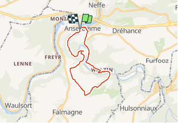
Trail Walking of 11.4 km to be discovered at Wallonia, Namur, Dinant. This trail is proposed by ScarniereLaurent.
Description
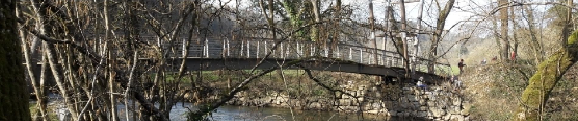
Magnifique randonnée du bord de Lesse au depart de la Salle Saint-Anne d'Anseremme. Facilité de parking sur la place de l'église. Après la montée en tarmac depuis le camping de Villatoile, traversée de la cour arrière d'une ferme. La descente vers la Lesse donne droit à une vue sur le Château de Walzin et la nouvelle passerelle. Pas de difficultés majeures. Chemins boueux si temps humide ainsi que tarmaqués et semi-empierrés.
Positioning
Comments
Trails nearby
![Walking Walking](https://static1.geolcdn.com/sitytour/trail-icons/101.png)
Walking
![](/images/other/stat-length.png)
![](https://static1.geolcdn.com/siteimages/upload/files/16400158638029165_repeat_loop_refresh_sync_direction_icon.png)
![Trail Walking Houyet - GG-NA-20_Gendron-Celles - Dinant - Photo](https://media.geolcdn.com/t/375/260/ab939ff5-5b33-43fd-b036-e462abc33a68.jpg&format=jpg&maxdim=2)
![Walking Walking](https://static1.geolcdn.com/sitytour/trail-icons/101.png)
Walking
![](/images/other/stat-length.png)
![](https://static1.geolcdn.com/siteimages/upload/files/16400158638029165_repeat_loop_refresh_sync_direction_icon.png)
![Trail Walking Dinant - Balade à Dinant - La Réserve Naturelle de Moniat - Photo](https://media.geolcdn.com/t/375/260/765b9b62-b29c-4537-9ff6-9d29c15be9d8.jpg&format=jpg&maxdim=2)
![Walking Walking](https://static1.geolcdn.com/sitytour/trail-icons/101.png)
Walking
![](/images/other/stat-length.png)
![](https://static1.geolcdn.com/siteimages/upload/files/16400158638029165_repeat_loop_refresh_sync_direction_icon.png)
![Trail Walking Dinant - D'Anseremme à Dinant - Photo](https://media.geolcdn.com/t/375/260/ext.jpg?maxdim=2&url=https%3A%2F%2Fservices.sitytrail.com%2FGeolivesWS%2FDownloadMedia.ashx%3FTrailID%3D375788%26Media%3D9ffb86bd-da6e-4936-82b7-07dbdf349394.JPG)
![Walking Walking](https://static1.geolcdn.com/sitytour/trail-icons/101.png)
Walking
![](/images/other/stat-length.png)
![](https://static1.geolcdn.com/siteimages/upload/files/16400158638029165_repeat_loop_refresh_sync_direction_icon.png)
![Trail Walking Dinant - Balade à Bouvignes - Photo](https://media.geolcdn.com/t/375/260/ext.jpg?maxdim=2&url=https%3A%2F%2Fservices.sitytrail.com%2FGeolivesWS%2FDownloadMedia.ashx%3FTrailID%3D223072%26Media%3D8dae2923-6a84-4680-856b-d65e95092209.JPG)
![Walking Walking](https://static1.geolcdn.com/sitytour/trail-icons/101.png)
Walking
![](/images/other/stat-length.png)
![](https://static1.geolcdn.com/siteimages/upload/files/16400158638029165_repeat_loop_refresh_sync_direction_icon.png)
![Trail Walking Dinant - Balade en Réserve Naturelle de Devant Bouvignes - Photo](https://media.geolcdn.com/t/375/260/ext.jpg?maxdim=2&url=https%3A%2F%2Fservices.sitytrail.com%2FGeolivesWS%2FDownloadMedia.ashx%3FTrailID%3D222999%26Media%3D231bd4cd-9ad4-4a88-bcf6-84f0725ce446.JPG)
![Walking Walking](https://static1.geolcdn.com/sitytour/trail-icons/101.png)
Walking
![](/images/other/stat-length.png)
![](https://static1.geolcdn.com/siteimages/upload/files/16400158638029165_repeat_loop_refresh_sync_direction_icon.png)
![Trail Walking Dinant - Dinant: autour de la Citadelle. - Photo](https://media.geolcdn.com/t/375/260/0debd692-1141-41b3-8018-db8fdb788a39.jpg&format=jpg&maxdim=2)
![Walking Walking](https://static1.geolcdn.com/sitytour/trail-icons/101.png)
Walking
![](/images/other/stat-length.png)
![](https://static1.geolcdn.com/siteimages/upload/files/16400158638029165_repeat_loop_refresh_sync_direction_icon.png)
![Walking Walking](https://static1.geolcdn.com/sitytour/trail-icons/101.png)
Walking
![](/images/other/stat-length.png)
![](https://static1.geolcdn.com/siteimages/upload/files/16400158638029165_repeat_loop_refresh_sync_direction_icon.png)
![Trail Walking Dinant - DINANT ... Montagne de la Croix et l’ île d'Amour. - Photo](https://media.geolcdn.com/t/375/260/62b66370-733a-438b-8532-4002241cc41c.jpg&format=jpg&maxdim=2)
![Walking Walking](https://static1.geolcdn.com/sitytour/trail-icons/101.png)
Walking
![](/images/other/stat-length.png)
![](https://static1.geolcdn.com/siteimages/upload/files/16400158638029165_repeat_loop_refresh_sync_direction_icon.png)