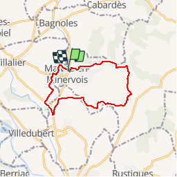
![](/images/other/stat-length.png)
![Trail Walking Malves-en-Minervois - Du menhir au château à MALVES EN MINERVOIS 11600 - Photo](https://media.geolcdn.com/t/1900/400/ext.pjpeg?maxdim=2&url=https%3A%2F%2Fstatic1.geolcdn.com%2Fsiteimages%2Fupload%2Ffiles%2F1553511878bg_sport_marche.png)
Du menhir au château à MALVES EN MINERVOIS 11600
Denisnr
User
![Length](/images/other/stat-length.png)
![Max alt](https://static1.geolcdn.com/siteimages/upload/files/1508320355ic_sort_altitude_max_24dp.png)
![Uphill gradient](https://static1.geolcdn.com/siteimages/upload/files/1508320355ic_sort_den_pos_24dp.png)
![Km-Effort](/images/other/stat-length.png)
![Min alt](https://static1.geolcdn.com/siteimages/upload/files/1508320355ic_sort_altitude_min_24dp.png)
![Downhill gradient](https://static1.geolcdn.com/siteimages/upload/files/1508320355ic_sort_den_neg_24dp.png)
![Boucle](https://static1.geolcdn.com/siteimages/upload/files/16400158638029165_repeat_loop_refresh_sync_direction_icon.png)
![Walking](https://static1.geolcdn.com/sitytour/trail-icons/101.png)
3h09
Difficulty : Easy
![Scan this QR Code to open this trail in the SityTrail application](https://capi.geolives.com/qq0zvz2zws4bq2lad0pu/sitytour/trails/905156/qr.png?size=200)
FREE GPS app for hiking
About
Trail Walking of 12.1 km to be discovered at Occitania, Aude, Malves-en-Minervois. This trail is proposed by Denisnr.
Description
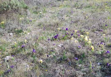
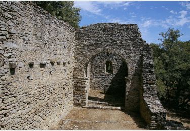
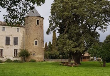
Départ sur le parking de la salle des fêtes. Après avoir traversé la rivière la clamoux, sur une colline se dresse le menhir de 5 mètres de hauteur (peyro ficado). Par la suite cheminement entre vignes et champs, par sentiers et chemins. A mis parcours passage au point culminant de la randonnée à "l'esquino del ase". Passage dans une pinède puis retour vers le village par las planos et la jasse. Contournement du parc du château et des dépendances. Petite halte historique au château.
Positioning
Comments
Trails nearby
![Trail Mountain bike Villegly - Cap Nore 2009 60km - Photo](https://media.geolcdn.com/t/375/260/ext.jpg?maxdim=2&url=https%3A%2F%2Fservices.sitytrail.com%2FGeolivesWS%2FDownloadMedia.ashx%3FTrailID%3D103550%26Media%3D5793_6.jpg)
![Mountain bike Mountain bike](https://static1.geolcdn.com/sitytour/trail-icons/202.png)
Mountain bike
![](/images/other/stat-length.png)
![](https://static1.geolcdn.com/siteimages/upload/files/16400158638029165_repeat_loop_refresh_sync_direction_icon.png)
![Trail Walking Villegly - Wisigoths - Photo](https://media.geolcdn.com/t/375/260/b23e85ab-30ba-44e7-ba87-562da392561a.jpg&format=jpg&maxdim=2)
![Walking Walking](https://static1.geolcdn.com/sitytour/trail-icons/101.png)
![Trail Walking Rustiques - SityTrail - Rustiques - Buadelle - Canet - Photo](https://media.geolcdn.com/t/375/260/ext.jpg?maxdim=2&url=https%3A%2F%2Fstatic1.geolcdn.com%2Fsiteimages%2Fupload%2Ffiles%2F1553511878bg_sport_marche.png)
![Walking Walking](https://static1.geolcdn.com/sitytour/trail-icons/101.png)
Walking
![](/images/other/stat-length.png)
![](https://static1.geolcdn.com/siteimages/upload/files/16400158638029165_repeat_loop_refresh_sync_direction_icon.png)
![Trail On foot Villarzel-Cabardès - Sentier des Wisigoths Villarzel Cabardes - Photo](https://media.geolcdn.com/t/375/260/9be6d263-55a8-4490-a85a-8c17a619cef3.jpg&format=jpg&maxdim=2)
![On foot On foot](https://static1.geolcdn.com/sitytour/trail-icons/100.png)
On foot
![](/images/other/stat-length.png)
![](https://static1.geolcdn.com/siteimages/upload/files/16400158638029165_repeat_loop_refresh_sync_direction_icon.png)
![Trail Walking Villegly - la combe de St Martin à Villegly - Photo](https://media.geolcdn.com/t/375/260/9a0174c9-e7fb-4313-8744-bab2313c03eb.jpg&format=jpg&maxdim=2)
![Walking Walking](https://static1.geolcdn.com/sitytour/trail-icons/101.png)
Walking
![](/images/other/stat-length.png)
![](https://static1.geolcdn.com/siteimages/upload/files/16400158638029165_repeat_loop_refresh_sync_direction_icon.png)
![Trail On foot Villarzel-Cabardès - Sentiers des Wisigoths - Photo](https://media.geolcdn.com/t/375/260/020d7906-1b44-4f82-9bf7-6ef802f93b09.jpeg&format=jpg&maxdim=2)
![On foot On foot](https://static1.geolcdn.com/sitytour/trail-icons/100.png)
On foot
![](/images/other/stat-length.png)
![](https://static1.geolcdn.com/siteimages/upload/files/16400158638029165_repeat_loop_refresh_sync_direction_icon.png)
![Trail Walking Villalier - boucle Villalier La Mee les cabanes dans les bois - Photo](https://media.geolcdn.com/t/375/260/972fae87-5c6c-4b20-be31-502366586551.jpg&format=jpg&maxdim=2)
![Walking Walking](https://static1.geolcdn.com/sitytour/trail-icons/101.png)
Walking
![](/images/other/stat-length.png)
![](https://static1.geolcdn.com/siteimages/upload/files/16400158638029165_repeat_loop_refresh_sync_direction_icon.png)
![Trail Road bike Trèbes - Trèbes - Photo](https://media.geolcdn.com/t/375/260/7f0ec953-1f3b-4cac-b9b5-6223073e860e.jpg&format=jpg&maxdim=2)
![Road bike Road bike](https://static1.geolcdn.com/sitytour/trail-icons/201.png)
![Trail Walking Malves-en-Minervois - malves villemoustaussou AR - Photo](https://media.geolcdn.com/t/375/260/ext.jpg?maxdim=2&url=https%3A%2F%2Fstatic1.geolcdn.com%2Fsiteimages%2Fupload%2Ffiles%2F1553511878bg_sport_marche.png)
![Walking Walking](https://static1.geolcdn.com/sitytour/trail-icons/101.png)
Walking
![](/images/other/stat-length.png)
![](https://static1.geolcdn.com/siteimages/upload/files/16400158638029165_repeat_loop_refresh_sync_direction_icon.png)