![](/images/other/stat-length.png)
![Trail Walking Malville - sentier du tertre - Photo](https://media.geolcdn.com/t/1900/400/ext.pjpeg?maxdim=2&url=https%3A%2F%2Fstatic1.geolcdn.com%2Fsiteimages%2Fupload%2Ffiles%2F1553511878bg_sport_marche.png)
sentier du tertre
PhilippeLegault
User
![Length](/images/other/stat-length.png)
Length
11.6 km
![Max alt](https://static1.geolcdn.com/siteimages/upload/files/1508320355ic_sort_altitude_max_24dp.png)
Max alt
85 m
![Uphill gradient](https://static1.geolcdn.com/siteimages/upload/files/1508320355ic_sort_den_pos_24dp.png)
Uphill gradient
115 m
![Km-Effort](/images/other/stat-length.png)
Km-Effort
13.1 km
![Min alt](https://static1.geolcdn.com/siteimages/upload/files/1508320355ic_sort_altitude_min_24dp.png)
Min alt
20 m
![Downhill gradient](https://static1.geolcdn.com/siteimages/upload/files/1508320355ic_sort_den_neg_24dp.png)
Downhill gradient
114 m
![Boucle](https://static1.geolcdn.com/siteimages/upload/files/16400158638029165_repeat_loop_refresh_sync_direction_icon.png)
Boucle
Yes
Creation date :
2018-04-17 18:25:50.788
Updated on :
2018-04-17 18:25:50.788
![Walking](https://static1.geolcdn.com/sitytour/trail-icons/101.png)
4h08
Difficulty : Very easy
![Scan this QR Code to open this trail in the SityTrail application](https://capi.geolives.com/qq0zvz2zws4bq2lad0pu/sitytour/trails/903492/qr.png?size=200)
FREE GPS app for hiking
About
Trail Walking of 11.6 km to be discovered at Pays de la Loire, Loire-Atlantique, Malville. This trail is proposed by PhilippeLegault.
Description
Très belle randonnée, uniquement sur des chemins. Les 2 sentiers du début et de la fin sont très beaux.
Positioning
Country:
France
Region :
Pays de la Loire
Department/Province :
Loire-Atlantique
Municipality :
Malville
Location:
Unknown
Start:(Dec)
Start:(UTM)
584380 ; 5242317 (30T) N.
Comments
Trails nearby
![Trail Walking Bouée - Sentier des Belles Demeures et le port de Rohars - Photo](https://media.geolcdn.com/t/375/260/ext.jpg?maxdim=2&url=https%3A%2F%2Fservices.sitytrail.com%2FGeolivesWS%2FDownloadMedia.ashx%3FTrailID%3D129885%26Media%3D13455_6.jpg)
![Walking Walking](https://static1.geolcdn.com/sitytour/trail-icons/101.png)
Sentier des Belles Demeures et le port de Rohars
Walking
Difficult
(2)
Bouée,
Pays de la Loire,
Loire-Atlantique,
France
![](/images/other/stat-length.png)
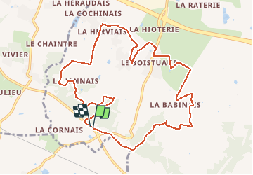
13.1 km | 14.1 km-effort
3h 15min
![](https://static1.geolcdn.com/siteimages/upload/files/16400158638029165_repeat_loop_refresh_sync_direction_icon.png)
Yes
![Trail Walking Bouée - Sentier des Belles Demeures par le sentier de Couebas - Bouée - Photo](https://media.geolcdn.com/t/375/260/ext.jpg?maxdim=2&url=https%3A%2F%2Fservices.sitytrail.com%2FGeolivesWS%2FDownloadMedia.ashx%3FTrailID%3D129884%26Media%3D13454_4.jpg)
![Walking Walking](https://static1.geolcdn.com/sitytour/trail-icons/101.png)
Sentier des Belles Demeures par le sentier de Couebas - Bouée
Walking
Easy
Bouée,
Pays de la Loire,
Loire-Atlantique,
France
![](/images/other/stat-length.png)
4.6 km | 5 km-effort
1h 10min
![](https://static1.geolcdn.com/siteimages/upload/files/16400158638029165_repeat_loop_refresh_sync_direction_icon.png)
Yes
![Trail Walking Bouée - Sentier des Belles Demeures - Bouée - Photo](https://media.geolcdn.com/t/375/260/ext.jpg?maxdim=2&url=https%3A%2F%2Fservices.sitytrail.com%2FGeolivesWS%2FDownloadMedia.ashx%3FTrailID%3D129883%26Media%3D13453_4.jpg)
![Walking Walking](https://static1.geolcdn.com/sitytour/trail-icons/101.png)
Sentier des Belles Demeures - Bouée
Walking
Medium
Bouée,
Pays de la Loire,
Loire-Atlantique,
France
![](/images/other/stat-length.png)
10.1 km | 10.9 km-effort
2h 30min
![](https://static1.geolcdn.com/siteimages/upload/files/16400158638029165_repeat_loop_refresh_sync_direction_icon.png)
Yes
![Trail Walking Malville - Sentier de la Coulée du Goust - Malville - Photo](https://media.geolcdn.com/t/375/260/ext.jpg?maxdim=2&url=https%3A%2F%2Fservices.sitytrail.com%2FGeolivesWS%2FDownloadMedia.ashx%3FTrailID%3D129882%26Media%3D13452_3.jpg)
![Walking Walking](https://static1.geolcdn.com/sitytour/trail-icons/101.png)
Sentier de la Coulée du Goust - Malville
Walking
Easy
(2)
Malville,
Pays de la Loire,
Loire-Atlantique,
France
![](/images/other/stat-length.png)
5.3 km | 6.3 km-effort
1h 30min
![](https://static1.geolcdn.com/siteimages/upload/files/16400158638029165_repeat_loop_refresh_sync_direction_icon.png)
Yes
![Trail Bicycle tourism Savenay - De Savenay à La Gacilly - Photo](https://media.geolcdn.com/t/375/260/5ee099ba-69f8-4dd1-8ab7-c93395ed925a.jpg&format=jpg&maxdim=2)
![Bicycle tourism Bicycle tourism](https://static1.geolcdn.com/sitytour/trail-icons/204.png)
De Savenay à La Gacilly
Bicycle tourism
Medium
Savenay,
Pays de la Loire,
Loire-Atlantique,
France
![](/images/other/stat-length.png)
67 km | 74 km-effort
3h 16min
![](https://static1.geolcdn.com/siteimages/upload/files/16400158638029165_repeat_loop_refresh_sync_direction_icon.png)
No
![Trail Electric bike Savenay - Lac de Savenay /Lavau sur Loire - Photo](https://media.geolcdn.com/t/375/260/f6f676c1-d77b-4930-b872-02daed4a7f08.jpg&format=jpg&maxdim=2)
![Electric bike Electric bike](https://static1.geolcdn.com/sitytour/trail-icons/205.png)
Lac de Savenay /Lavau sur Loire
Electric bike
Easy
Savenay,
Pays de la Loire,
Loire-Atlantique,
France
![](/images/other/stat-length.png)
21 km | 23 km-effort
1h 47min
![](https://static1.geolcdn.com/siteimages/upload/files/16400158638029165_repeat_loop_refresh_sync_direction_icon.png)
Yes
![Trail Mountain bike Cordemais - Cordemais 2024 - Photo](https://media.geolcdn.com/t/375/260/ext.jpg?maxdim=2&url=https%3A%2F%2Fstatic1.geolcdn.com%2Fsiteimages%2Fupload%2Ffiles%2F1524743154velo.jpg)
![Mountain bike Mountain bike](https://static1.geolcdn.com/sitytour/trail-icons/202.png)
Cordemais 2024
Mountain bike
Difficult
Cordemais,
Pays de la Loire,
Loire-Atlantique,
France
![](/images/other/stat-length.png)
34 km | 40 km-effort
2h 45min
![](https://static1.geolcdn.com/siteimages/upload/files/16400158638029165_repeat_loop_refresh_sync_direction_icon.png)
Yes
![Trail Horseback riding Cordemais - Equidécup 2023 17 km - Photo](https://media.geolcdn.com/t/375/260/ext.jpg?maxdim=2&url=https%3A%2F%2Fstatic1.geolcdn.com%2Fsiteimages%2Fupload%2Ffiles%2F1524743154cheval.jpg)
![Horseback riding Horseback riding](https://static1.geolcdn.com/sitytour/trail-icons/301.png)
Equidécup 2023 17 km
Horseback riding
Easy
(1)
Cordemais,
Pays de la Loire,
Loire-Atlantique,
France
![](/images/other/stat-length.png)
16.7 km | 17.7 km-effort
2h 19min
![](https://static1.geolcdn.com/siteimages/upload/files/16400158638029165_repeat_loop_refresh_sync_direction_icon.png)
Yes
![Trail Horseback riding Cordemais - Equidécup 2023 11 km - Photo](https://media.geolcdn.com/t/375/260/ext.jpg?maxdim=2&url=https%3A%2F%2Fstatic1.geolcdn.com%2Fsiteimages%2Fupload%2Ffiles%2F1524743154cheval.jpg)
![Horseback riding Horseback riding](https://static1.geolcdn.com/sitytour/trail-icons/301.png)
Equidécup 2023 11 km
Horseback riding
Easy
Cordemais,
Pays de la Loire,
Loire-Atlantique,
France
![](/images/other/stat-length.png)
10.6 km | 11.4 km-effort
1h 29min
![](https://static1.geolcdn.com/siteimages/upload/files/16400158638029165_repeat_loop_refresh_sync_direction_icon.png)
Yes