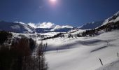

Col de l'Âne/Eissalette

R@ph
User GUIDE

Length
5.3 km

Max alt
2518 m

Uphill gradient
840 m

Km-Effort
13.7 km

Min alt
1671 m

Downhill gradient
1 m
Boucle
No
Creation date :
2018-04-17 18:20:50.714
Updated on :
2018-07-19 10:03:04.129
2h00
Difficulty : Medium

FREE GPS app for hiking
About
Trail Touring skiing of 5.3 km to be discovered at Provence-Alpes-Côte d'Azur, Hautes-Alpes, Les Orres. This trail is proposed by R@ph.
Description
Montée au col de l'Âne/Eissalette en ski de rando sous un soleil radieux,très bonne neige. Le froid -9 et l'absence de vent l'ont bien préservée. De nombreux skieurs dans l'ascension.
Positioning
Country:
France
Region :
Provence-Alpes-Côte d'Azur
Department/Province :
Hautes-Alpes
Municipality :
Les Orres
Location:
Unknown
Start:(Dec)
Start:(UTM)
305188 ; 4928503 (32T) N.
Comments
Trails nearby
le pic de Boussolenc par la tête du vallon Rémollon


Walking
Medium
(1)
Les Orres,
Provence-Alpes-Côte d'Azur,
Hautes-Alpes,
France

7.7 km | 13.7 km-effort
4h 50min
Yes
lac de Sainte Marguerite Les Orres


Walking
Medium
(2)
Les Orres,
Provence-Alpes-Côte d'Azur,
Hautes-Alpes,
France

11.1 km | 19 km-effort
4h 25min
Yes
2012-08-10_Sentier du garde


Walking
Medium
(1)
Les Orres,
Provence-Alpes-Côte d'Azur,
Hautes-Alpes,
France

11.3 km | 17.6 km-effort
4h 6min
Yes
Les Orres 1800 - Savines le Lac


Mountain bike
Difficult
(1)
Les Orres,
Provence-Alpes-Côte d'Azur,
Hautes-Alpes,
France

28 km | 42 km-effort
3h 0min
No
l'Aupillon


Walking
Difficult
Les Orres,
Provence-Alpes-Côte d'Azur,
Hautes-Alpes,
France

16.8 km | 33 km-effort
7h 43min
Yes
le Pouzenc


Walking
Difficult
Les Orres,
Provence-Alpes-Côte d'Azur,
Hautes-Alpes,
France

14.6 km | 31 km-effort
7h 41min
Yes
les orres 1800 . lac sainte marguerite / montée par le sentier et retour par ...


Walking
Easy
Les Orres,
Provence-Alpes-Côte d'Azur,
Hautes-Alpes,
France

10.2 km | 18.2 km-effort
3h 59min
Yes

Lac de Sainte Marguerite. Les ORRES


Snowshoes
Medium
(2)
Les Orres,
Provence-Alpes-Côte d'Azur,
Hautes-Alpes,
France

6.8 km | 13.4 km-effort
3h 26min
No
circuit 7 les Orres


Mountain bike
Difficult
Les Orres,
Provence-Alpes-Côte d'Azur,
Hautes-Alpes,
France

27 km | 41 km-effort
2h 44min
Yes


 SityTrail


