![](/images/other/stat-length.png)
![Trail Nordic walking Yutz - yutz 29 10 2011 - Photo](https://media.geolcdn.com/t/1900/400/ext.pjpeg?maxdim=2&url=https%3A%2F%2Fstatic1.geolcdn.com%2Fsiteimages%2Fupload%2Ffiles%2F1545311037marcheuse_200dpi.jpg)
yutz 29 10 2011
targoff
User
![Length](/images/other/stat-length.png)
Length
6.4 km
![Max alt](https://static1.geolcdn.com/siteimages/upload/files/1508320355ic_sort_altitude_max_24dp.png)
Max alt
209 m
![Uphill gradient](https://static1.geolcdn.com/siteimages/upload/files/1508320355ic_sort_den_pos_24dp.png)
Uphill gradient
109 m
![Km-Effort](/images/other/stat-length.png)
Km-Effort
7.8 km
![Min alt](https://static1.geolcdn.com/siteimages/upload/files/1508320355ic_sort_altitude_min_24dp.png)
Min alt
177 m
![Downhill gradient](https://static1.geolcdn.com/siteimages/upload/files/1508320355ic_sort_den_neg_24dp.png)
Downhill gradient
104 m
![Boucle](https://static1.geolcdn.com/siteimages/upload/files/16400158638029165_repeat_loop_refresh_sync_direction_icon.png)
Boucle
Yes
Creation date :
2014-12-10 00:00:00.0
Updated on :
2014-12-10 00:00:00.0
![Nordic walking](https://static1.geolcdn.com/sitytour/trail-icons/102.png)
1h46
Difficulty : Very easy
![Scan this QR Code to open this trail in the SityTrail application](https://capi.geolives.com/qq0zvz2zws4bq2lad0pu/sitytour/trails/89875/qr.png?size=200)
FREE GPS app for hiking
About
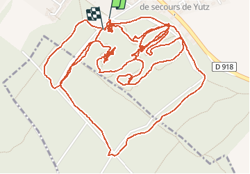
Trail Nordic walking of 6.4 km to be discovered at Grand Est, Moselle, Yutz. This trail is proposed by targoff.
Description
Marche Nordique dans le cadre d'un club incluant 30 minutes, échauffement, exercices, étirements) ainsi que des boucles permettant de rattraper les moins rapides
Positioning
Country:
France
Region :
Grand Est
Department/Province :
Moselle
Municipality :
Yutz
Location:
Unknown
Start:(Dec)
Start:(UTM)
296561 ; 5469441 (32U) N.
Comments
Trails nearby
![Trail Cycle Thionville - promenade du dimanche - Photo](https://media.geolcdn.com/t/375/260/ext.jpg?maxdim=2&url=https%3A%2F%2Fstatic1.geolcdn.com%2Fsiteimages%2Fupload%2Ffiles%2F1524743154velo.jpg)
![Cycle Cycle](https://static1.geolcdn.com/sitytour/trail-icons/200.png)
promenade du dimanche
Cycle
Very easy
(1)
Thionville,
Grand Est,
Moselle,
France
![](/images/other/stat-length.png)
25 km | 28 km-effort
1h 40min
![](https://static1.geolcdn.com/siteimages/upload/files/16400158638029165_repeat_loop_refresh_sync_direction_icon.png)
Yes
![Trail Walking Thionville - Thionville oeutrange - Photo](https://media.geolcdn.com/t/375/260/ext.jpg?maxdim=2&url=https%3A%2F%2Fservices.sitytrail.com%2FGeolivesWS%2FDownloadMedia.ashx%3FTrailID%3D396822%26Media%3Dfix__20150316133200.jpg)
![Walking Walking](https://static1.geolcdn.com/sitytour/trail-icons/101.png)
Thionville oeutrange
Walking
Very easy
(1)
Thionville,
Grand Est,
Moselle,
France
![](/images/other/stat-length.png)
16.4 km | 22 km-effort
3h 11min
![](https://static1.geolcdn.com/siteimages/upload/files/16400158638029165_repeat_loop_refresh_sync_direction_icon.png)
Yes
![Trail Mountain bike Manom - manomoise 2013 28km - Photo](https://media.geolcdn.com/t/375/260/ext.jpg?maxdim=2&url=https%3A%2F%2Fstatic1.geolcdn.com%2Fsiteimages%2Fupload%2Ffiles%2F1524743154velo.jpg)
![Mountain bike Mountain bike](https://static1.geolcdn.com/sitytour/trail-icons/202.png)
manomoise 2013 28km
Mountain bike
Medium
(1)
Manom,
Grand Est,
Moselle,
France
![](/images/other/stat-length.png)
29 km | 35 km-effort
3h 24min
![](https://static1.geolcdn.com/siteimages/upload/files/16400158638029165_repeat_loop_refresh_sync_direction_icon.png)
Yes
![Trail Walking Thionville - thionville : je suis venu, j ai vu, je reviendrai plus - Photo](https://media.geolcdn.com/t/375/260/90f961b9-cea4-4f20-8aa5-acf05bf5a6d8.jpg&format=jpg&maxdim=2)
![Walking Walking](https://static1.geolcdn.com/sitytour/trail-icons/101.png)
thionville : je suis venu, j ai vu, je reviendrai plus
Walking
Very easy
Thionville,
Grand Est,
Moselle,
France
![](/images/other/stat-length.png)
6.7 km | 7.5 km-effort
3h 23min
![](https://static1.geolcdn.com/siteimages/upload/files/16400158638029165_repeat_loop_refresh_sync_direction_icon.png)
Yes
![Trail On foot Yutz - Circuit Mermoz - Photo](https://media.geolcdn.com/t/375/260/9ce668cb-e4c3-4198-9202-3f713c53c393.jpeg&format=jpg&maxdim=2)
![On foot On foot](https://static1.geolcdn.com/sitytour/trail-icons/100.png)
![Trail On foot Illange - Circuit du Fort d'Illange et Yutz - Photo](https://media.geolcdn.com/t/375/260/f49347b3-7f37-4c66-8b6c-118a9ccde5f2.jpeg&format=jpg&maxdim=2)
![On foot On foot](https://static1.geolcdn.com/sitytour/trail-icons/100.png)
Circuit du Fort d'Illange et Yutz
On foot
Easy
Illange,
Grand Est,
Moselle,
France
![](/images/other/stat-length.png)
5.2 km | 6 km-effort
1h 21min
![](https://static1.geolcdn.com/siteimages/upload/files/16400158638029165_repeat_loop_refresh_sync_direction_icon.png)
No
![Trail Electric bike Thionville - Eurégio 2024 J3 Thionville - Photo](https://media.geolcdn.com/t/375/260/0091c666-794f-4f4e-bfb5-67f65eb3c4c3.jpg&format=jpg&maxdim=2)
![Electric bike Electric bike](https://static1.geolcdn.com/sitytour/trail-icons/205.png)
Eurégio 2024 J3 Thionville
Electric bike
Very easy
Thionville,
Grand Est,
Moselle,
France
![](/images/other/stat-length.png)
48 km | 56 km-effort
4h 0min
![](https://static1.geolcdn.com/siteimages/upload/files/16400158638029165_repeat_loop_refresh_sync_direction_icon.png)
Yes
![Trail On foot Manom - Boucle du Château de la Grange - Photo](https://media.geolcdn.com/t/375/260/3df1054c-c533-435f-a2f8-79979c92be3d.jpeg&format=jpg&maxdim=2)
![On foot On foot](https://static1.geolcdn.com/sitytour/trail-icons/100.png)
Boucle du Château de la Grange
On foot
Easy
Manom,
Grand Est,
Moselle,
France
![](/images/other/stat-length.png)
5.2 km | 6.5 km-effort
1h 28min
![](https://static1.geolcdn.com/siteimages/upload/files/16400158638029165_repeat_loop_refresh_sync_direction_icon.png)
No
![Trail On foot Thionville - Sentier des vignerons - Photo](https://media.geolcdn.com/t/375/260/0e8ea12c-91de-4da2-8649-026e9be2b9b6.jpeg&format=jpg&maxdim=2)
![On foot On foot](https://static1.geolcdn.com/sitytour/trail-icons/100.png)
Sentier des vignerons
On foot
Easy
Thionville,
Grand Est,
Moselle,
France
![](/images/other/stat-length.png)
3.4 km | 4.4 km-effort
59min
![](https://static1.geolcdn.com/siteimages/upload/files/16400158638029165_repeat_loop_refresh_sync_direction_icon.png)
Yes