Trail Walking Solliès-Toucas -  Siou Blanc : Autour des Bidoufles  - Photo

Siou Blanc : Autour des Bidoufles

© OpenStreetMap contributors
Length
Length
13.2 km
Max alt
Max alt
729 m
Uphill gradient
Uphill gradient
413 m
Km-Effort
Km-Effort  
18.7 km
Min alt
Min alt
441 m
Downhill gradient
Downhill gradient
413 m
Boucle
Boucle
Yes
Creation date :
2018-04-17 17:45:27.576
Updated on :
2023-02-13 14:57:02.462

(0 Reviews)

Walking
Walking
4h00
Difficulty : Medium

Scan this QR Code to open this trail in the SityTrail application

FREE GPS app for hiking

Logo SityTrail SityTrail

IGN / Geographical institutes

Download SityTrail from the App Store Download SityTrail from Google Play

Logo SityTrail SityTrail World

The world is yours!

Download SityTrail from the App Store Download SityTrail from Google Play Download SityTrail on Huawei AppGallery

About

Trail Walking of 13.2 km to be discovered at Provence-Alpes-Côte d'Azur, Var, Solliès-Toucas. This trail is proposed by sonneville.

Description

Dp de la  <route forestière pt 655 Pt 596, Pas du Pilon, pt 581 Ubac de Valbelle, portes de Valbelle, retour par pt 624 et bouche ouinte

Elevation profile

Positioning

Country:
France
Region :
Provence-Alpes-Côte d'Azur
Department/Province :
Var
Municipality :
Solliès-Toucas
Location:
Unknown
Start:(UTM)
738789 ; 4789232 (31T) N.

Trails nearby

Trail Walking Solliès-Toucas - Morières : la Garoute et la Baume des Lumes - Photo
Walking
GUIDE
affinetataille

Walking

Easy
(1)
Solliès-Toucas, Provence-Alpes-Côte d'Azur, Var, France
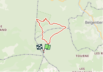
12.6 km | 16.7 km-effort
6h 0min
Yes
Trail Walking Belgentier - Chemin de la Foux - Pas de Belgentier - Pont de la Garoute - Photo
Walking
FSantoni

Walking

Very difficult
(1)
Belgentier, Provence-Alpes-Côte d'Azur, Var, France
17.2 km | 26 km-effort
5h 51min
Yes
Trail Walking Solliès-Toucas - Valaury - Apier - Matheron - Photo
Walking
GUIDE
affinetataille

Walking

Medium
(1)
Solliès-Toucas, Provence-Alpes-Côte d'Azur, Var, France
13.1 km | 19.5 km-effort
5h 0min
Yes
Trail Walking Solliès-Toucas - SityTrail - siou blanc - Photo
Walking
GUIDE
affinetataille

Walking

Medium
(1)
Solliès-Toucas, Provence-Alpes-Côte d'Azur, Var, France
12.5 km | 17.4 km-effort
6h 0min
Yes
Trail Walking Méounes-lès-Montrieux - SityTrail - montrieux gapeau - Photo
Walking
GUIDE
affinetataille

Walking

Very difficult
(2)
Méounes-lès-Montrieux, Provence-Alpes-Côte d'Azur, Var, France
15.9 km | 23 km-effort
5h 14min
Yes
Trail Walking Le Revest-les-Eaux - 83 barrage revest les eaux 24-05-2021 - Photo
Walking
GUIDE
randodyssée

Walking

Medium
(1)
Le Revest-les-Eaux, Provence-Alpes-Côte d'Azur, Var, France
8 km | 12.3 km-effort
3h 41min
Yes
Trail Walking Méounes-lès-Montrieux - Chartreuse de Montreuil le jeune - Photo
Walking
martinemarie

Walking

Easy
(1)
Méounes-lès-Montrieux, Provence-Alpes-Côte d'Azur, Var, France
11.9 km | 17.1 km-effort
5h 10min
Yes
Trail Walking Solliès-Toucas - couvent St Hubert Valaury - Photo
Walking
marchev

Walking

Very easy
(2)
Solliès-Toucas, Provence-Alpes-Côte d'Azur, Var, France
12.5 km | 19.2 km-effort
4h 30min
Yes
Trail Trail Belgentier - Les aiguilles de Valberg et une arche - Photo
Trail
GUIDE
nadd73

Trail

Easy
Belgentier, Provence-Alpes-Côte d'Azur, Var, France
12.6 km | 19.5 km-effort
2h 17min
Yes


Close
My subscriptions