![](/images/other/stat-length.png)
![Trail Walking Rochefort - VTT 1(RO39) - Photo](https://media.geolcdn.com/t/1900/400/ext.pjpeg?maxdim=2&url=https%3A%2F%2Fservices.sitytrail.com%2FGeolivesWS%2FDownloadMedia.ashx%3FTrailID%3D89477%26Media%3DCGT_0005_00000135_00005047_20552.jpg)
VTT 1(RO39)
© OpenStreetMap contributors
![Walking](https://static1.geolcdn.com/sitytour/trail-icons/101.png)
Walking
2h52
Difficulty : Very easy
![Length](/images/other/stat-length.png)
Length
63 km
![Max alt](https://static1.geolcdn.com/siteimages/upload/files/1508320355ic_sort_altitude_max_24dp.png)
Max alt
326 m
![Uphill gradient](https://static1.geolcdn.com/siteimages/upload/files/1508320355ic_sort_den_pos_24dp.png)
Uphill gradient
1235 m
![Km-Effort](/images/other/stat-length.png)
Km-Effort
80 km
![Min alt](https://static1.geolcdn.com/siteimages/upload/files/1508320355ic_sort_altitude_min_24dp.png)
Min alt
142 m
![Downhill gradient](https://static1.geolcdn.com/siteimages/upload/files/1508320355ic_sort_den_neg_24dp.png)
Downhill gradient
1236 m
![Boucle](https://static1.geolcdn.com/siteimages/upload/files/16400158638029165_repeat_loop_refresh_sync_direction_icon.png)
Boucle
Yes
Creation date :
2014-12-10 00:00:00.0
Updated on :
2014-12-10 00:00:00.0
![Walking](https://static1.geolcdn.com/sitytour/trail-icons/101.png)
2h52
Difficulty : Very easy
![Scan this QR Code to open this trail in the SityTrail application](https://capi.geolives.com/qq0zvz2zws4bq2lad0pu/sitytour/trails/89477/qr.png?size=200)
FREE GPS app for hiking
About
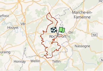
Trail Walking of 63 km to be discovered at Wallonia, Namur, Rochefort. This trail is proposed by frederique.marti@laposte.net.
Description
Lessive vers le bois de Briquemont (Sud) puis traversée des petits villages de Navaugle, Buissonville, retour vers Rochefort
Points of interest
Positioning
Country:
Belgium
Region :
Wallonia
Department/Province :
Namur
Municipality :
Rochefort
Location:
Rochefort
Start:(Dec)
Start:(UTM)
658815 ; 5558761 (31U) N.
Comments
Trails nearby
![Trail Walking Rochefort - Havrenne & de Saint-Remy Trappist Abbey - Photo](https://media.geolcdn.com/t/375/260/ext.jpg?maxdim=2&url=https%3A%2F%2Fservices.sitytrail.com%2FGeolivesWS%2FDownloadMedia.ashx%3FTrailID%3D215623%26Media%3Db529a95c-404d-4caa-9c09-6087624067bf.tif)
![Walking Walking](https://static1.geolcdn.com/sitytour/trail-icons/101.png)
Havrenne & de Saint-Remy Trappist Abbey
Walking
Easy
(14)
Rochefort,
Wallonia,
Namur,
Belgium
![](/images/other/stat-length.png)
6 km | 7.1 km-effort
2h 0min
![](https://static1.geolcdn.com/siteimages/upload/files/16400158638029165_repeat_loop_refresh_sync_direction_icon.png)
Yes
![Trail Walking Rochefort - Nature - The view from the Belvédère in Han-sur-Lesse - Photo](https://media.geolcdn.com/t/375/260/ext.jpg?maxdim=2&url=https%3A%2F%2Fservices.sitytrail.com%2FGeolivesWS%2FDownloadMedia.ashx%3FTrailID%3D193579%26Media%3D5797bc56-5327-4c2b-b581-d88d672bf775.jpg)
![Walking Walking](https://static1.geolcdn.com/sitytour/trail-icons/101.png)
Nature - The view from the Belvédère in Han-sur-Lesse
Walking
Difficult
(16)
Rochefort,
Wallonia,
Namur,
Belgium
![](/images/other/stat-length.png)
4.8 km | 6.3 km-effort
1h 20min
![](https://static1.geolcdn.com/siteimages/upload/files/16400158638029165_repeat_loop_refresh_sync_direction_icon.png)
Yes
![Trail Motor Rochefort - Car tour - Heritage : churches, chapels and abbeys - Rochefort - Photo](https://media.geolcdn.com/t/375/260/ext.jpg?maxdim=2&url=https%3A%2F%2Fservices.sitytrail.com%2FGeolivesWS%2FDownloadMedia.ashx%3FTrailID%3D153103%26Media%3D05603f1b-9f7c-481f-bc84-6cc819555dbb.jpg)
![Motor Motor](https://static1.geolcdn.com/sitytour/trail-icons/400.png)
Car tour - Heritage : churches, chapels and abbeys - Rochefort
Motor
Easy
(5)
Rochefort,
Wallonia,
Namur,
Belgium
![](/images/other/stat-length.png)
65 km | 78 km-effort
2h 40min
![](https://static1.geolcdn.com/siteimages/upload/files/16400158638029165_repeat_loop_refresh_sync_direction_icon.png)
Yes
![Trail Walking Rochefort - RB-Na-07 Raccourci - Ronde au pays des grottes - Photo](https://media.geolcdn.com/t/375/260/ext.jpg?maxdim=2&url=https%3A%2F%2Fservices.sitytrail.com%2FGeolivesWS%2FDownloadMedia.ashx%3FTrailID%3D213757%26Media%3D27dc9085-0323-4669-9df4-56be0512bfe6.jpg)
![Walking Walking](https://static1.geolcdn.com/sitytour/trail-icons/101.png)
RB-Na-07 Raccourci - Ronde au pays des grottes
Walking
Easy
(9)
Rochefort,
Wallonia,
Namur,
Belgium
![](/images/other/stat-length.png)
18.4 km | 24 km-effort
4h 59min
![](https://static1.geolcdn.com/siteimages/upload/files/16400158638029165_repeat_loop_refresh_sync_direction_icon.png)
Yes
![Trail Walking Rochefort - Nature - A discovery trail through Han-sur-Lesse - Photo](https://media.geolcdn.com/t/375/260/ext.jpg?maxdim=2&url=https%3A%2F%2Fservices.sitytrail.com%2FGeolivesWS%2FDownloadMedia.ashx%3FTrailID%3D148989%26Media%3D3c202c2f-ee01-4903-bd25-24913ec8637b.jpg)
![Walking Walking](https://static1.geolcdn.com/sitytour/trail-icons/101.png)
Nature - A discovery trail through Han-sur-Lesse
Walking
Very easy
(15)
Rochefort,
Wallonia,
Namur,
Belgium
![](/images/other/stat-length.png)
4.8 km | 5.8 km-effort
1h 15min
![](https://static1.geolcdn.com/siteimages/upload/files/16400158638029165_repeat_loop_refresh_sync_direction_icon.png)
Yes
![Walking Walking](https://static1.geolcdn.com/sitytour/trail-icons/101.png)
GG2-Lu-34_Jemelle-Marche-en-Famenne (2021-11-04)
Walking
Medium
(1)
Rochefort,
Wallonia,
Namur,
Belgium
![](/images/other/stat-length.png)
19.2 km | 24 km-effort
5h 32min
![](https://static1.geolcdn.com/siteimages/upload/files/16400158638029165_repeat_loop_refresh_sync_direction_icon.png)
No
![Trail Motor Rochefort - Roadbook](https://media.geolcdn.com/t/375/260/ext.jpg?maxdim=2&url=https%3A%2F%2Fservices.sitytrail.com%2FGeolivesWS%2FDownloadMedia.ashx%3FTrailID%3D428715%26Media%3Dff47641a-75c9-4285-926b-b7008d6e40b8.png)
![Motor Motor](https://static1.geolcdn.com/sitytour/trail-icons/400.png)
Roadbook "On the road by car/motorbike" - "Local delicacies, crafts and tradi...
Motor
Very easy
(3)
Rochefort,
Wallonia,
Namur,
Belgium
![](/images/other/stat-length.png)
140 km | 169 km-effort
2h 0min
![](https://static1.geolcdn.com/siteimages/upload/files/16400158638029165_repeat_loop_refresh_sync_direction_icon.png)
Yes
![Trail Walking Nassogne - Forrières/Lesterny - Promenade Saint-Martin (NG 08) - Photo](https://media.geolcdn.com/t/375/260/ext.jpg?maxdim=2&url=https%3A%2F%2Fservices.sitytrail.com%2FGeolivesWS%2FDownloadMedia.ashx%3FTrailID%3D334477%26Media%3Dba77daec-7d1b-4594-8484-87260d6142b8.jpg)
![Walking Walking](https://static1.geolcdn.com/sitytour/trail-icons/101.png)
Forrières/Lesterny - Promenade Saint-Martin (NG 08)
Walking
Medium
(4)
Nassogne,
Wallonia,
Luxembourg,
Belgium
![](/images/other/stat-length.png)
7.3 km | 9 km-effort
1h 57min
![](https://static1.geolcdn.com/siteimages/upload/files/16400158638029165_repeat_loop_refresh_sync_direction_icon.png)
Yes
![Trail Walking Nassogne - Forrières - Promenade de Cocher (NG 07) - Photo](https://media.geolcdn.com/t/375/260/ext.jpg?maxdim=2&url=https%3A%2F%2Fservices.sitytrail.com%2FGeolivesWS%2FDownloadMedia.ashx%3FTrailID%3D334476%26Media%3D562f483c-8c06-4d7b-aecf-2f9a32b3894e.jpg)
![Walking Walking](https://static1.geolcdn.com/sitytour/trail-icons/101.png)
Forrières - Promenade de Cocher (NG 07)
Walking
Medium
(3)
Nassogne,
Wallonia,
Luxembourg,
Belgium
![](/images/other/stat-length.png)
5.4 km | 6.7 km-effort
1h 28min
![](https://static1.geolcdn.com/siteimages/upload/files/16400158638029165_repeat_loop_refresh_sync_direction_icon.png)
Yes