![](/images/other/stat-length.png)
![Trail Mountain bike Gap - VTT20 - Aux frontières du champsaur - Photo](https://media.geolcdn.com/t/1900/400/44e67644-4e5a-4974-b56d-22780b759746.jpg&format=pjpeg&maxdim=2)
VTT20 - Aux frontières du champsaur
Camping Les Rives du Lac
Les Hautes Alpes à découvrir ! GUIDE+
![Length](/images/other/stat-length.png)
![Max alt](https://static1.geolcdn.com/siteimages/upload/files/1508320355ic_sort_altitude_max_24dp.png)
![Uphill gradient](https://static1.geolcdn.com/siteimages/upload/files/1508320355ic_sort_den_pos_24dp.png)
![Km-Effort](/images/other/stat-length.png)
![Min alt](https://static1.geolcdn.com/siteimages/upload/files/1508320355ic_sort_altitude_min_24dp.png)
![Downhill gradient](https://static1.geolcdn.com/siteimages/upload/files/1508320355ic_sort_den_neg_24dp.png)
![Boucle](https://static1.geolcdn.com/siteimages/upload/files/16400158638029165_repeat_loop_refresh_sync_direction_icon.png)
![Mountain bike](https://static1.geolcdn.com/sitytour/trail-icons/202.png)
2h51
Difficulty : Medium
![Scan this QR Code to open this trail in the SityTrail application](https://capi.geolives.com/qq0zvz2zws4bq2lad0pu/sitytour/trails/894034/qr.png?size=200)
FREE GPS app for hiking
About
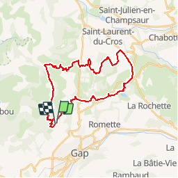
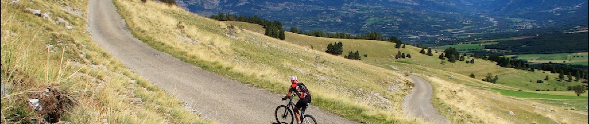
Trail Mountain bike of 31 km to be discovered at Provence-Alpes-Côte d'Azur, Hautes-Alpes, Gap. This trail is proposed by Camping Les Rives du Lac.
Description
To change the massif and landscape, this hike is really interesting: Starting from the castle of Charance, you will follow the path along the canal. Beautiful view of the Gapençais. Then climb towards GAP Bayard, no technical difficulty at this stage. Mounted much more sustained then to the Col de Gleize (Magnificent view). Beautiful descent to the starting point, mostly on a single track. From the Château de Charance, follow the markings 8 of the "Gapençais Valleys"
Positioning
Comments
Trails nearby
![Trail Walking Gap - Brèche et croix de Charance - Photo](https://media.geolcdn.com/t/375/260/ext.jpg?maxdim=2&url=https%3A%2F%2Fservices.sitytrail.com%2FGeolivesWS%2FDownloadMedia.ashx%3FTrailID%3D95802%26Media%3D20111201151419.jpg)
![Walking Walking](https://static1.geolcdn.com/sitytour/trail-icons/101.png)
Walking
![](/images/other/stat-length.png)
![](https://static1.geolcdn.com/siteimages/upload/files/16400158638029165_repeat_loop_refresh_sync_direction_icon.png)
![Trail Walking Rabou - Rabou Tour du Puy - Photo](https://media.geolcdn.com/t/375/260/805e1ce0-378d-4868-bdbb-2f6f352f7b11.jpg&format=jpg&maxdim=2)
![Walking Walking](https://static1.geolcdn.com/sitytour/trail-icons/101.png)
Walking
![](/images/other/stat-length.png)
![](https://static1.geolcdn.com/siteimages/upload/files/16400158638029165_repeat_loop_refresh_sync_direction_icon.png)
![Trail Walking Gap - Pic de Charance - Photo](https://media.geolcdn.com/t/375/260/1b819787-5cbc-4e39-b2ee-7b1b220b0af8.jpg&format=jpg&maxdim=2)
![Walking Walking](https://static1.geolcdn.com/sitytour/trail-icons/101.png)
Walking
![](/images/other/stat-length.png)
![](https://static1.geolcdn.com/siteimages/upload/files/16400158638029165_repeat_loop_refresh_sync_direction_icon.png)
![Trail Walking Rabou - Pic Melette - Photo](https://media.geolcdn.com/t/375/260/4622a0c3-66f1-414b-9c6c-2d569eb751b3.jpg&format=jpg&maxdim=2)
![Walking Walking](https://static1.geolcdn.com/sitytour/trail-icons/101.png)
Walking
![](/images/other/stat-length.png)
![](https://static1.geolcdn.com/siteimages/upload/files/16400158638029165_repeat_loop_refresh_sync_direction_icon.png)
![Trail Walking Gap - Pic de Gleize - Photo](https://media.geolcdn.com/t/375/260/9b3dcddd-15e9-4793-a987-aa74cd6c203d.jpg&format=jpg&maxdim=2)
![Walking Walking](https://static1.geolcdn.com/sitytour/trail-icons/101.png)
Walking
![](/images/other/stat-length.png)
![](https://static1.geolcdn.com/siteimages/upload/files/16400158638029165_repeat_loop_refresh_sync_direction_icon.png)
![Trail Walking Gap - Cuchon-Pic de Charance - Photo](https://media.geolcdn.com/t/375/260/273370c5-f091-46d0-92ed-fb2a447f25db.jpg&format=jpg&maxdim=2)
![Walking Walking](https://static1.geolcdn.com/sitytour/trail-icons/101.png)
Walking
![](/images/other/stat-length.png)
![](https://static1.geolcdn.com/siteimages/upload/files/16400158638029165_repeat_loop_refresh_sync_direction_icon.png)
![Trail Walking Gap - Col de Guizière - Photo](https://media.geolcdn.com/t/375/260/48c56f83-5df5-469d-a27d-85eb85489bb3.jpg&format=jpg&maxdim=2)
![Walking Walking](https://static1.geolcdn.com/sitytour/trail-icons/101.png)
Walking
![](/images/other/stat-length.png)
![](https://static1.geolcdn.com/siteimages/upload/files/16400158638029165_repeat_loop_refresh_sync_direction_icon.png)
![Trail Walking Gap - 7 Chemin GAP - LA MOTTE DU CAIRE - Photo](https://media.geolcdn.com/t/375/260/b07614fe-04fc-4765-a9ca-f9a239129cad.jpg&format=jpg&maxdim=2)
![Walking Walking](https://static1.geolcdn.com/sitytour/trail-icons/101.png)
Walking
![](/images/other/stat-length.png)
![](https://static1.geolcdn.com/siteimages/upload/files/16400158638029165_repeat_loop_refresh_sync_direction_icon.png)
![Trail On foot Rabou - 9587041 - Photo](https://media.geolcdn.com/t/375/260/6a1636b4-b223-413d-a187-700130d298fe.jpg&format=jpg&maxdim=2)
![On foot On foot](https://static1.geolcdn.com/sitytour/trail-icons/100.png)
On foot
![](/images/other/stat-length.png)
![](https://static1.geolcdn.com/siteimages/upload/files/16400158638029165_repeat_loop_refresh_sync_direction_icon.png)