![](/images/other/stat-length.png)
![Trail Walking Bouère - De Bouère à St-Brice - Photo](https://media.geolcdn.com/t/1900/400/ext.pjpeg?maxdim=2&url=https%3A%2F%2Fstatic1.geolcdn.com%2Fsiteimages%2Fupload%2Ffiles%2F1553511878bg_sport_marche.png)
De Bouère à St-Brice
neoroll44
User
![Length](/images/other/stat-length.png)
Length
13 km
![Max alt](https://static1.geolcdn.com/siteimages/upload/files/1508320355ic_sort_altitude_max_24dp.png)
Max alt
83 m
![Uphill gradient](https://static1.geolcdn.com/siteimages/upload/files/1508320355ic_sort_den_pos_24dp.png)
Uphill gradient
142 m
![Km-Effort](/images/other/stat-length.png)
Km-Effort
14.9 km
![Min alt](https://static1.geolcdn.com/siteimages/upload/files/1508320355ic_sort_altitude_min_24dp.png)
Min alt
46 m
![Downhill gradient](https://static1.geolcdn.com/siteimages/upload/files/1508320355ic_sort_den_neg_24dp.png)
Downhill gradient
143 m
![Boucle](https://static1.geolcdn.com/siteimages/upload/files/16400158638029165_repeat_loop_refresh_sync_direction_icon.png)
Boucle
Yes
Creation date :
2018-04-17 16:59:16.576
Updated on :
2018-04-17 16:59:16.576
![Walking](https://static1.geolcdn.com/sitytour/trail-icons/101.png)
3h15
Difficulty : Medium
![Scan this QR Code to open this trail in the SityTrail application](https://capi.geolives.com/qq0zvz2zws4bq2lad0pu/sitytour/trails/893860/qr.png?size=200)
FREE GPS app for hiking
About
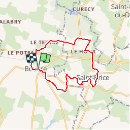
Trail Walking of 13 km to be discovered at Pays de la Loire, Mayenne, Bouère. This trail is proposed by neoroll44.
Description
Non loin de la forêt de Bellebranche.
De l'église, prendre le CD 14 vers Grez en Bouère, puis à droite vers la croix verte.
Puis le Moulin Neuf, Manchetière, près de Bellebranche et retour par St-Brice et le plan d'eau.
Positioning
Country:
France
Region :
Pays de la Loire
Department/Province :
Mayenne
Municipality :
Bouère
Location:
Unknown
Start:(Dec)
Start:(UTM)
688652 ; 5304229 (30T) N.
Comments
Trails nearby
![Trail Walking Bouère - Bouère. Circuit N4 - Photo](https://media.geolcdn.com/t/375/260/ext.jpg?maxdim=2&url=https%3A%2F%2Fstatic1.geolcdn.com%2Fsiteimages%2Fupload%2Ffiles%2F1553511878bg_sport_marche.png)
![Walking Walking](https://static1.geolcdn.com/sitytour/trail-icons/101.png)
Bouère. Circuit N4
Walking
Easy
(1)
Bouère,
Pays de la Loire,
Mayenne,
France
![](/images/other/stat-length.png)
4.5 km | 5.4 km-effort
1h 38min
![](https://static1.geolcdn.com/siteimages/upload/files/16400158638029165_repeat_loop_refresh_sync_direction_icon.png)
Yes
![Trail Walking Grez-en-Bouère - Grez en Bouère - Photo](https://media.geolcdn.com/t/375/260/ext.jpg?maxdim=2&url=https%3A%2F%2Fstatic1.geolcdn.com%2Fsiteimages%2Fupload%2Ffiles%2F1553511878bg_sport_marche.png)
![Walking Walking](https://static1.geolcdn.com/sitytour/trail-icons/101.png)
Grez en Bouère
Walking
Medium
Grez-en-Bouère,
Pays de la Loire,
Mayenne,
France
![](/images/other/stat-length.png)
12.8 km | 14.8 km-effort
3h 20min
![](https://static1.geolcdn.com/siteimages/upload/files/16400158638029165_repeat_loop_refresh_sync_direction_icon.png)
Yes
![Trail Walking Saint-Brice - 2024 06 02 bellebranche - Photo](https://media.geolcdn.com/t/375/260/ext.jpg?maxdim=2&url=https%3A%2F%2Fstatic1.geolcdn.com%2Fsiteimages%2Fupload%2Ffiles%2F1553511878bg_sport_marche.png)
![Walking Walking](https://static1.geolcdn.com/sitytour/trail-icons/101.png)
2024 06 02 bellebranche
Walking
Easy
Saint-Brice,
Pays de la Loire,
Mayenne,
France
![](/images/other/stat-length.png)
9 km | 10.4 km-effort
1h 59min
![](https://static1.geolcdn.com/siteimages/upload/files/16400158638029165_repeat_loop_refresh_sync_direction_icon.png)
Yes
![Trail Geocaching Saint-Loup-du-Dorat - Labyrinthe Alice Juillet 2022 - Photo](https://media.geolcdn.com/t/375/260/ext.jpg?maxdim=2&url=https%3A%2F%2Fstatic1.geolcdn.com%2Fsiteimages%2Fupload%2Ffiles%2F1545311037marcheuse_200dpi.jpg)
![Geocaching Geocaching](https://static1.geolcdn.com/sitytour/trail-icons/908.png)
Labyrinthe Alice Juillet 2022
Geocaching
Medium
Saint-Loup-du-Dorat,
Pays de la Loire,
Mayenne,
France
![](/images/other/stat-length.png)
11.8 km | 13.1 km-effort
2h 50min
![](https://static1.geolcdn.com/siteimages/upload/files/16400158638029165_repeat_loop_refresh_sync_direction_icon.png)
No
![Trail Walking Bouère - de Bouère à Grez - Photo](https://media.geolcdn.com/t/375/260/ext.jpg?maxdim=2&url=https%3A%2F%2Fstatic1.geolcdn.com%2Fsiteimages%2Fupload%2Ffiles%2F1553511878bg_sport_marche.png)
![Walking Walking](https://static1.geolcdn.com/sitytour/trail-icons/101.png)
de Bouère à Grez
Walking
Very easy
Bouère,
Pays de la Loire,
Mayenne,
France
![](/images/other/stat-length.png)
14.4 km | 16.6 km-effort
3h 55min
![](https://static1.geolcdn.com/siteimages/upload/files/16400158638029165_repeat_loop_refresh_sync_direction_icon.png)
Yes
![Trail Walking Bouère - Bouère. autour du village - Photo](https://media.geolcdn.com/t/375/260/ext.jpg?maxdim=2&url=https%3A%2F%2Fstatic1.geolcdn.com%2Fsiteimages%2Fupload%2Ffiles%2F1553511878bg_sport_marche.png)
![Walking Walking](https://static1.geolcdn.com/sitytour/trail-icons/101.png)
Bouère. autour du village
Walking
Medium
Bouère,
Pays de la Loire,
Mayenne,
France
![](/images/other/stat-length.png)
11.4 km | 13.1 km-effort
3h 5min
![](https://static1.geolcdn.com/siteimages/upload/files/16400158638029165_repeat_loop_refresh_sync_direction_icon.png)
Yes
![Trail Walking Saint-Brice - Saint-Brice Marche à pied - Photo](https://media.geolcdn.com/t/375/260/ext.jpg?maxdim=2&url=https%3A%2F%2Fstatic1.geolcdn.com%2Fsiteimages%2Fupload%2Ffiles%2F1553511878bg_sport_marche.png)
![Walking Walking](https://static1.geolcdn.com/sitytour/trail-icons/101.png)
Saint-Brice Marche à pied
Walking
Medium
Saint-Brice,
Pays de la Loire,
Mayenne,
France
![](/images/other/stat-length.png)
9.2 km | 10.6 km-effort
2h 19min
![](https://static1.geolcdn.com/siteimages/upload/files/16400158638029165_repeat_loop_refresh_sync_direction_icon.png)
Yes