Trail Walking Oullins - Parcs et jardins d'Oullins - Photo
© OpenStreetMap contributors
Length
Length
9.2 km
Max alt
Max alt
251 m
Uphill gradient
Uphill gradient
171 m
Km-Effort
Km-Effort  
11.5 km
Min alt
Min alt
162 m
Downhill gradient
Downhill gradient
172 m
Boucle
Boucle
Yes
Creation date :
2018-04-17 16:54:18.345
Updated on :
2018-04-17 16:54:18.345

(0 Reviews)

Walking
Walking
2h30
Difficulty : Easy

Scan this QR Code to open this trail in the SityTrail application

FREE GPS app for hiking

Logo SityTrail SityTrail

IGN / Geographical institutes

Download SityTrail from the App Store Download SityTrail from Google Play

Logo SityTrail SityTrail World

The world is yours!

Download SityTrail from the App Store Download SityTrail from Google Play Download SityTrail on Huawei AppGallery

About

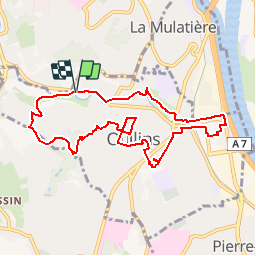
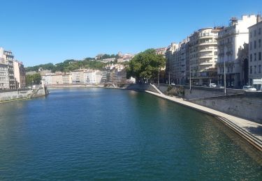
Trail Walking of 9.2 km to be discovered at Auvergne-Rhône-Alpes, Métropole de Lyon, Oullins. This trail is proposed by Delahalle.

Description

Parcours semi-urbain passant par les nombreux parcs et jardins d'Oullins. Ce parcours peut facilement être raccourci au besoin.
Départ et arrivée du parking Intermarché d'OUllins.

Elevation profile

Positioning

Country:
France
Region :
Auvergne-Rhône-Alpes
Department/Province :
Métropole de Lyon
Municipality :
Oullins
Location:
Unknown
Start:(UTM)
639536 ; 5064650 (31T) N.

Trails nearby

Trail Walking Lyon - De Place des Archives à Monplaisir - Photo
Walking
Marie-Hélène Luton 2

Walking

Difficult
(1)
Lyon, Auvergne-Rhône-Alpes, Métropole de Lyon, France
11.2 km | 12.9 km-effort
2h 55min
No
Trail Walking Francheville - Aqueduc et fort du Bruissin (PR1) - Photo
Walking
chuck

Walking

Easy
Francheville, Auvergne-Rhône-Alpes, Métropole de Lyon, France
19.1 km | 23 km-effort
5h 20min
Yes
Trail Walking Chaponost - de Chaponost à Brignais AR - Photo
Walking
maclobar

Walking

Difficult
Chaponost, Auvergne-Rhône-Alpes, Rhône, France
11.8 km | 14.3 km-effort
2h 40min
Yes
Trail Walking Chaponost - Chaponost boucle - Photo
Walking
maclobar

Walking

Medium
Chaponost, Auvergne-Rhône-Alpes, Rhône, France
9.2 km | 11.2 km-effort
1h 56min
Yes
Trail Walking Chaponost - Acqueducs de Chaponost à Beaunant - Photo
Walking
maclobar

Walking

Medium
Chaponost, Auvergne-Rhône-Alpes, Rhône, France
7 km | 9.2 km-effort
1h 35min
Yes
Trail Walking Sainte-Foy-lès-Lyon - Sainte foy les lyon - Photo
Walking
daniellebou

Walking

Difficult
(1)
Sainte-Foy-lès-Lyon, Auvergne-Rhône-Alpes, Métropole de Lyon, France
9.9 km | 13.2 km-effort
2h 52min
Yes
Trail Walking Lyon - Lyon autour de la traboule des voraces - Photo
Walking
GUIDE
stef789

Walking

Very easy
Lyon, Auvergne-Rhône-Alpes, Métropole de Lyon, France
4.1 km | 5.6 km-effort
1h 44min
Yes
Trail Walking Lyon - petite visite nocturne de Lyon - Photo
Walking
GUIDE
stef789

Walking

Very easy
Lyon, Auvergne-Rhône-Alpes, Métropole de Lyon, France
7.2 km | 8.5 km-effort
2h 23min
Yes
Trail Walking Lyon - Fnac - Photo
Walking
ricoux

Walking

Easy
(1)
Lyon, Auvergne-Rhône-Alpes, Métropole de Lyon, France
1.9 km | 2.3 km-effort
18min
No


Close
My subscriptions