![](/images/other/stat-length.png)
![Trail Other activity Mollans-sur-Ouvèze - Rand'eau dans le Toulourenc - Photo](https://media.geolcdn.com/t/1900/400/ext.pjpeg?maxdim=2&url=https%3A%2F%2Fstatic1.geolcdn.com%2Fsiteimages%2Fupload%2Ffiles%2F1545311037marcheuse_200dpi.jpg)
Rand'eau dans le Toulourenc
Coqorico
User
![Length](/images/other/stat-length.png)
Length
9.6 km
![Max alt](https://static1.geolcdn.com/siteimages/upload/files/1508320355ic_sort_altitude_max_24dp.png)
Max alt
517 m
![Uphill gradient](https://static1.geolcdn.com/siteimages/upload/files/1508320355ic_sort_den_pos_24dp.png)
Uphill gradient
336 m
![Km-Effort](/images/other/stat-length.png)
Km-Effort
14 km
![Min alt](https://static1.geolcdn.com/siteimages/upload/files/1508320355ic_sort_altitude_min_24dp.png)
Min alt
319 m
![Downhill gradient](https://static1.geolcdn.com/siteimages/upload/files/1508320355ic_sort_den_neg_24dp.png)
Downhill gradient
336 m
![Boucle](https://static1.geolcdn.com/siteimages/upload/files/16400158638029165_repeat_loop_refresh_sync_direction_icon.png)
Boucle
Yes
Creation date :
2018-04-17 16:53:18.816
Updated on :
2019-09-10 14:44:36.974
![Other activity](https://static1.geolcdn.com/sitytour/trail-icons/900.png)
--
Difficulty : Unknown
![Scan this QR Code to open this trail in the SityTrail application](https://capi.geolives.com/qq0zvz2zws4bq2lad0pu/sitytour/trails/893016/qr.png?size=200)
FREE GPS app for hiking
About
Trail Other activity of 9.6 km to be discovered at Auvergne-Rhône-Alpes, Drôme, Mollans-sur-Ouvèze. This trail is proposed by Coqorico.
Description
Randonnée très agréable dans le lit du Toulourenc à l'allée, puis par les hauteurs qui en dominent les gorges au retour.
À faire en été car les parties aquatiques ne peuvent pas être évitées. La température de l'eau est agréable.
Positioning
Country:
France
Region :
Auvergne-Rhône-Alpes
Department/Province :
Drôme
Municipality :
Mollans-sur-Ouvèze
Location:
Unknown
Start:(Dec)
Start:(UTM)
676821 ; 4898164 (31T) N.
Comments
Trails nearby
![Trail Walking Beaumont-du-Ventoux - Le Ventoux - Corniche Nord - Photo](https://media.geolcdn.com/t/375/260/ext.jpg?maxdim=2&url=https%3A%2F%2Fservices.sitytrail.com%2FGeolivesWS%2FDownloadMedia.ashx%3FTrailID%3D105329%26Media%3D9023_2.jpg)
![Walking Walking](https://static1.geolcdn.com/sitytour/trail-icons/101.png)
Le Ventoux - Corniche Nord
Walking
Difficult
(2)
Beaumont-du-Ventoux,
Provence-Alpes-Côte d'Azur,
Vaucluse,
France
![](/images/other/stat-length.png)
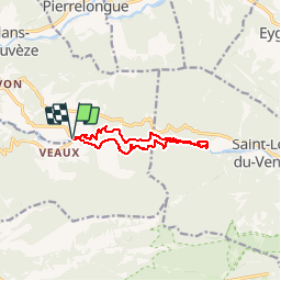
19.1 km | 30 km-effort
6h 30min
![](https://static1.geolcdn.com/siteimages/upload/files/16400158638029165_repeat_loop_refresh_sync_direction_icon.png)
Yes
![Trail Walking Beaumont-du-Ventoux - Sentier de découverte au Mont Serein - Photo](https://media.geolcdn.com/t/375/260/ext.jpg?maxdim=2&url=https%3A%2F%2Fservices.sitytrail.com%2FGeolivesWS%2FDownloadMedia.ashx%3FTrailID%3D103767%26Media%3D6520_2.jpg)
![Walking Walking](https://static1.geolcdn.com/sitytour/trail-icons/101.png)
Sentier de découverte au Mont Serein
Walking
Medium
(2)
Beaumont-du-Ventoux,
Provence-Alpes-Côte d'Azur,
Vaucluse,
France
![](/images/other/stat-length.png)
6.3 km | 8.2 km-effort
2h 0min
![](https://static1.geolcdn.com/siteimages/upload/files/16400158638029165_repeat_loop_refresh_sync_direction_icon.png)
Yes
![Trail On foot Mollans-sur-Ouvèze - Roubion - Photo](https://media.geolcdn.com/t/375/260/acc73179-5e12-4051-b44f-b0980aab9979.jpeg&format=jpg&maxdim=2)
![On foot On foot](https://static1.geolcdn.com/sitytour/trail-icons/100.png)
Roubion
On foot
Easy
Mollans-sur-Ouvèze,
Auvergne-Rhône-Alpes,
Drôme,
France
![](/images/other/stat-length.png)
4.6 km | 7.3 km-effort
1h 39min
![](https://static1.geolcdn.com/siteimages/upload/files/16400158638029165_repeat_loop_refresh_sync_direction_icon.png)
Yes
![Trail On foot Mollans-sur-Ouvèze - Pisserouille - Photo](https://media.geolcdn.com/t/375/260/acc73179-5e12-4051-b44f-b0980aab9979.jpeg&format=jpg&maxdim=2)
![On foot On foot](https://static1.geolcdn.com/sitytour/trail-icons/100.png)
Pisserouille
On foot
Easy
Mollans-sur-Ouvèze,
Auvergne-Rhône-Alpes,
Drôme,
France
![](/images/other/stat-length.png)
3.5 km | 5.9 km-effort
1h 19min
![](https://static1.geolcdn.com/siteimages/upload/files/16400158638029165_repeat_loop_refresh_sync_direction_icon.png)
Yes
![Trail On foot Mollans-sur-Ouvèze - Crête et Ubac de Bluye - Photo](https://media.geolcdn.com/t/375/260/1f6fc386-d1d3-46f5-84c8-16749c58c4c0.jpeg&format=jpg&maxdim=2)
![On foot On foot](https://static1.geolcdn.com/sitytour/trail-icons/100.png)
Crête et Ubac de Bluye
On foot
Easy
Mollans-sur-Ouvèze,
Auvergne-Rhône-Alpes,
Drôme,
France
![](/images/other/stat-length.png)
7.4 km | 12.8 km-effort
2h 54min
![](https://static1.geolcdn.com/siteimages/upload/files/16400158638029165_repeat_loop_refresh_sync_direction_icon.png)
Yes
![Trail On foot Mollans-sur-Ouvèze - Adret de Bluye - Photo](https://media.geolcdn.com/t/375/260/1f6fc386-d1d3-46f5-84c8-16749c58c4c0.jpeg&format=jpg&maxdim=2)
![On foot On foot](https://static1.geolcdn.com/sitytour/trail-icons/100.png)
Adret de Bluye
On foot
Easy
Mollans-sur-Ouvèze,
Auvergne-Rhône-Alpes,
Drôme,
France
![](/images/other/stat-length.png)
9.1 km | 16.6 km-effort
3h 46min
![](https://static1.geolcdn.com/siteimages/upload/files/16400158638029165_repeat_loop_refresh_sync_direction_icon.png)
Yes
![Trail On foot Mollans-sur-Ouvèze - Mollans - Pierrelongue - Photo](https://media.geolcdn.com/t/375/260/acc73179-5e12-4051-b44f-b0980aab9979.jpeg&format=jpg&maxdim=2)
![On foot On foot](https://static1.geolcdn.com/sitytour/trail-icons/100.png)
Mollans - Pierrelongue
On foot
Easy
(1)
Mollans-sur-Ouvèze,
Auvergne-Rhône-Alpes,
Drôme,
France
![](/images/other/stat-length.png)
7.5 km | 10.9 km-effort
2h 28min
![](https://static1.geolcdn.com/siteimages/upload/files/16400158638029165_repeat_loop_refresh_sync_direction_icon.png)
Yes
![Trail Walking Beaumont-du-Ventoux - Crêtes du Ventoux - Photo](https://media.geolcdn.com/t/375/260/91441923-a9c0-4765-9dda-d1eb9e281d5f.jpg&format=jpg&maxdim=2)
![Walking Walking](https://static1.geolcdn.com/sitytour/trail-icons/101.png)
Crêtes du Ventoux
Walking
Difficult
Beaumont-du-Ventoux,
Provence-Alpes-Côte d'Azur,
Vaucluse,
France
![](/images/other/stat-length.png)
18.8 km | 29 km-effort
6h 4min
![](https://static1.geolcdn.com/siteimages/upload/files/16400158638029165_repeat_loop_refresh_sync_direction_icon.png)
Yes
![Trail Walking Mollans-sur-Ouvèze - mollans-sur-ouveze-2019 - Photo](https://media.geolcdn.com/t/375/260/ext.jpg?maxdim=2&url=https%3A%2F%2Fstatic1.geolcdn.com%2Fsiteimages%2Fupload%2Ffiles%2F1553511878bg_sport_marche.png)
![Walking Walking](https://static1.geolcdn.com/sitytour/trail-icons/101.png)
mollans-sur-ouveze-2019
Walking
Medium
(1)
Mollans-sur-Ouvèze,
Auvergne-Rhône-Alpes,
Drôme,
France
![](/images/other/stat-length.png)
7.6 km | 10.5 km-effort
2h 12min
![](https://static1.geolcdn.com/siteimages/upload/files/16400158638029165_repeat_loop_refresh_sync_direction_icon.png)
Yes