Trail Walking Jonage - GL16 Pont de Jonage-bon-rallonge 3 à tester 7 a 57 g0 d18 V24 - Photo

GL16 Pont de Jonage-bon-rallonge 3 à tester 7 a 57 g0 d18 V24

© OpenStreetMap contributors
Length
Length
7 km
Max alt
Max alt
193 m
Uphill gradient
Uphill gradient
54 m
Km-Effort
Km-Effort  
7.7 km
Min alt
Min alt
178 m
Downhill gradient
Downhill gradient
55 m
Boucle
Boucle
Yes
Creation date :
2018-04-17 16:45:53.808
Updated on :
2018-04-17 16:45:53.808

(1 Reviews)

Walking
Walking
1h43
Difficulty : Easy

Scan this QR Code to open this trail in the SityTrail application

FREE GPS app for hiking

Logo SityTrail SityTrail

IGN / Geographical institutes

Download SityTrail from the App Store Download SityTrail from Google Play

Logo SityTrail SityTrail World

The world is yours!

Download SityTrail from the App Store Download SityTrail from Google Play Download SityTrail on Huawei AppGallery

About

Trail Walking of 7 km to be discovered at Auvergne-Rhône-Alpes, Métropole de Lyon, Jonage. This trail is proposed by lydiaodile.

Description

GL16 Pont de Jonage– Trajet voiture 18 km 24 min45°48'18.4"N 5°02'51.4"E ou 45.805100, 5.047600 Pk Ch du Plançon, 69330 JonageContournement Est , sortie 7 Pusignan-Pont de Chéruy, puis 1er rd pt : 2e sortie, 2e rd pt : 2e sortie direction de Z.I. Meyzieu. Jonage.Rd Pt suivant : 3e sortie, Rd pt suivant 2e sortie Ch des Poteaux-Rd pt suivant 3e sortie Bd Louis Pradel, suivre tt droit puis tourner à gauche Pt de Jonage, traverser le pt, tourner à droite ch du Plançon, jusqu’au parking

Elevation profile

Positioning

Country:
France
Region :
Auvergne-Rhône-Alpes
Department/Province :
Métropole de Lyon
Municipality :
Jonage
Location:
Unknown
Start:(UTM)
659107 ; 5074429 (31T) N.

Comments

Please log in to post a review or rate the element


Trails nearby

Trail Walking Beynost - cibleBeynost - Photo
Walking
adelore

Walking

Very easy
Beynost, Auvergne-Rhône-Alpes, Ain, France
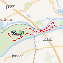
1.2 km | 1.4 km-effort
37min
No
Trail Walking Meyzieu - 30 mai - Photo
Walking
d.brient

Walking

Medium
Meyzieu, Auvergne-Rhône-Alpes, Métropole de Lyon, France
7.9 km | 8.7 km-effort
1h 23min
Yes
Trail Walking Meyzieu - 27 mars 24 - Photo
Walking
d.brient

Walking

Medium
Meyzieu, Auvergne-Rhône-Alpes, Métropole de Lyon, France
8.9 km | 9.5 km-effort
1h 33min
Yes
Trail Walking Meyzieu - 2 - Photo
Walking
d.brient

Walking

Medium
Meyzieu, Auvergne-Rhône-Alpes, Métropole de Lyon, France
8.5 km | 9.4 km-effort
1h 26min
Yes
Trail Walking Meyzieu - Plaine de l'Est Lyonnais - Photo
Walking
chuck

Walking

Easy
Meyzieu, Auvergne-Rhône-Alpes, Métropole de Lyon, France
19 km | 21 km-effort
4h 49min
Yes
Trail Walking Meyzieu - Meyzieux  - Photo
Walking
jwo47

Walking

Easy
Meyzieu, Auvergne-Rhône-Alpes, Métropole de Lyon, France
4.6 km | 4.8 km-effort
1h 12min
Yes
Trail Walking Meyzieu - pédestre pont d'eyrbens  - Photo
Walking
lydiaodile

Walking

Difficult
Meyzieu, Auvergne-Rhône-Alpes, Métropole de Lyon, France
14.5 km | 15.8 km-effort
3h 43min
Yes
Trail Mountain bike Thil - test - Photo
Mountain bike
adelore

Mountain bike

Medium
Thil, Auvergne-Rhône-Alpes, Ain, France
26 km | 28 km-effort
52h 7min
Yes
Trail Walking Meyzieu - Pont d’Herbens - La Forestière  - Photo
Walking
pzvictor

Walking

Very easy
(1)
Meyzieu, Auvergne-Rhône-Alpes, Métropole de Lyon, France
9.7 km | 10.4 km-effort
2h 47min
Yes


Close
My subscriptions