![](/images/other/stat-length.png)
![Trail Mountain bike Maasmechelen - B.Maasmechelen61A66.137VTC - Photo](https://media.geolcdn.com/t/1900/400/ext.pjpeg?maxdim=2&url=https%3A%2F%2Fstatic1.geolcdn.com%2Fsiteimages%2Fupload%2Ffiles%2F1524743154velo.jpg)
B.Maasmechelen61A66.137VTC
francois58
User
![Length](/images/other/stat-length.png)
![Max alt](https://static1.geolcdn.com/siteimages/upload/files/1508320355ic_sort_altitude_max_24dp.png)
![Uphill gradient](https://static1.geolcdn.com/siteimages/upload/files/1508320355ic_sort_den_pos_24dp.png)
![Km-Effort](/images/other/stat-length.png)
![Min alt](https://static1.geolcdn.com/siteimages/upload/files/1508320355ic_sort_altitude_min_24dp.png)
![Downhill gradient](https://static1.geolcdn.com/siteimages/upload/files/1508320355ic_sort_den_neg_24dp.png)
![Boucle](https://static1.geolcdn.com/siteimages/upload/files/16400158638029165_repeat_loop_refresh_sync_direction_icon.png)
![Mountain bike](https://static1.geolcdn.com/sitytour/trail-icons/202.png)
4h39
Difficulty : Easy
![Scan this QR Code to open this trail in the SityTrail application](https://capi.geolives.com/qq0zvz2zws4bq2lad0pu/sitytour/trails/891906/qr.png?size=200)
FREE GPS app for hiking
About
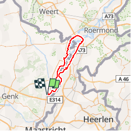
Trail Mountain bike of 66 km to be discovered at Flanders, Limburg, Maasmechelen. This trail is proposed by francois58.
Description
Boucle variée à la découverte du "Maasland" :
le Zuid Willemsvaart, la Meuse(passage en bac - gratuit pour les vélos), le Canal Juliana, les villages de Maasbracht, Thorn, Maaseik, les étangs de la Meuse et les pâturages de chevaux Konik et bovins Galloway.
Le tracé est facile - sur ravel et petites routes quasi tout en macadam - juste qqs toutes petites jonctions de chemins très praticables qui justifient à peine le choix du VTC plutôt que le vélo de route. 2 possibilités de raccourci si besoin
Positioning
Comments
Trails nearby
![Trail Walking Maasmechelen - Mechelse Heide - Photo](https://media.geolcdn.com/t/375/260/501f02e9-8086-4be8-98c9-f01120ddee06.jpg&format=jpg&maxdim=2)
![Walking Walking](https://static1.geolcdn.com/sitytour/trail-icons/101.png)
Walking
![](/images/other/stat-length.png)
![](https://static1.geolcdn.com/siteimages/upload/files/16400158638029165_repeat_loop_refresh_sync_direction_icon.png)
![Trail On foot Maasmechelen - Erfgoedwandeling Eisden Tuinwijk - Photo](https://media.geolcdn.com/t/375/260/28db0122-7bbc-4a11-ae3a-faea898e04f5.jpeg&format=jpg&maxdim=2)
![On foot On foot](https://static1.geolcdn.com/sitytour/trail-icons/100.png)
On foot
![](/images/other/stat-length.png)
![](https://static1.geolcdn.com/siteimages/upload/files/16400158638029165_repeat_loop_refresh_sync_direction_icon.png)
![Trail On foot Dilsen-Stokkem - Connecterra Rode driehoek - Photo](https://media.geolcdn.com/t/375/260/5eb5c103-eb27-4a59-83d3-dfd2672ebb0c.jpeg&format=jpg&maxdim=2)
![On foot On foot](https://static1.geolcdn.com/sitytour/trail-icons/100.png)
On foot
![](/images/other/stat-length.png)
![](https://static1.geolcdn.com/siteimages/upload/files/16400158638029165_repeat_loop_refresh_sync_direction_icon.png)
![Trail On foot Maasmechelen - Leut & Meeswijk Oranje bol - Photo](https://media.geolcdn.com/t/375/260/7b6d2e92-3c0b-4eee-8e68-d0c378b09212.jpeg&format=jpg&maxdim=2)
![On foot On foot](https://static1.geolcdn.com/sitytour/trail-icons/100.png)
On foot
![](/images/other/stat-length.png)
![](https://static1.geolcdn.com/siteimages/upload/files/16400158638029165_repeat_loop_refresh_sync_direction_icon.png)
![Trail On foot Maasmechelen - Leut & Meeswijk Rode driehoek - Photo](https://media.geolcdn.com/t/375/260/7b6d2e92-3c0b-4eee-8e68-d0c378b09212.jpeg&format=jpg&maxdim=2)
![On foot On foot](https://static1.geolcdn.com/sitytour/trail-icons/100.png)
On foot
![](/images/other/stat-length.png)
![](https://static1.geolcdn.com/siteimages/upload/files/16400158638029165_repeat_loop_refresh_sync_direction_icon.png)
![Trail On foot Maasmechelen - Leut & Meeswijk Gele zeshoek - Photo](https://media.geolcdn.com/t/375/260/3a349166-7856-4cc9-a007-a2d01b733e80.jpeg&format=jpg&maxdim=2)
![On foot On foot](https://static1.geolcdn.com/sitytour/trail-icons/100.png)
On foot
![](/images/other/stat-length.png)
![](https://static1.geolcdn.com/siteimages/upload/files/16400158638029165_repeat_loop_refresh_sync_direction_icon.png)
![Trail On foot Maasmechelen - Leut & Meeswijk Groene rechthoek - Photo](https://media.geolcdn.com/t/375/260/7b6d2e92-3c0b-4eee-8e68-d0c378b09212.jpeg&format=jpg&maxdim=2)
![On foot On foot](https://static1.geolcdn.com/sitytour/trail-icons/100.png)
On foot
![](/images/other/stat-length.png)
![](https://static1.geolcdn.com/siteimages/upload/files/16400158638029165_repeat_loop_refresh_sync_direction_icon.png)
![Trail On foot Maasmechelen - Leut & Meeswijk Blauwe ruit - Photo](https://media.geolcdn.com/t/375/260/7b6d2e92-3c0b-4eee-8e68-d0c378b09212.jpeg&format=jpg&maxdim=2)
![On foot On foot](https://static1.geolcdn.com/sitytour/trail-icons/100.png)
On foot
![](/images/other/stat-length.png)
![](https://static1.geolcdn.com/siteimages/upload/files/16400158638029165_repeat_loop_refresh_sync_direction_icon.png)
![Trail On foot Dilsen-Stokkem - Stokkem & Oud-Dilsen Rode driehoek - Photo](https://media.geolcdn.com/t/375/260/a792e625-34fe-45f0-9032-50fd0ca567ca.jpeg&format=jpg&maxdim=2)
![On foot On foot](https://static1.geolcdn.com/sitytour/trail-icons/100.png)
On foot
![](/images/other/stat-length.png)
![](https://static1.geolcdn.com/siteimages/upload/files/16400158638029165_repeat_loop_refresh_sync_direction_icon.png)