![](/images/other/stat-length.png)
![Trail Mountain bike Ouffet - OUFFET - Balade des Fermes - Photo](https://media.geolcdn.com/t/1900/400/ext.pjpeg?maxdim=2&url=https%3A%2F%2Fstatic1.geolcdn.com%2Fsiteimages%2Fupload%2Ffiles%2F1524743154velo.jpg)
OUFFET - Balade des Fermes
gk@icedd.be
User
![Length](/images/other/stat-length.png)
Length
7.7 km
![Max alt](https://static1.geolcdn.com/siteimages/upload/files/1508320355ic_sort_altitude_max_24dp.png)
Max alt
296 m
![Uphill gradient](https://static1.geolcdn.com/siteimages/upload/files/1508320355ic_sort_den_pos_24dp.png)
Uphill gradient
142 m
![Km-Effort](/images/other/stat-length.png)
Km-Effort
9.6 km
![Min alt](https://static1.geolcdn.com/siteimages/upload/files/1508320355ic_sort_altitude_min_24dp.png)
Min alt
225 m
![Downhill gradient](https://static1.geolcdn.com/siteimages/upload/files/1508320355ic_sort_den_neg_24dp.png)
Downhill gradient
141 m
![Boucle](https://static1.geolcdn.com/siteimages/upload/files/16400158638029165_repeat_loop_refresh_sync_direction_icon.png)
Boucle
Yes
![Signpost](https://services.sitytrail.com/GeolivesWS/DownloadMedia.ashx?TrailID=891187&Media=balise.png)
Signpost
Creation date :
2018-04-17 16:38:32.879
Updated on :
2018-04-17 16:38:32.879
![Mountain bike](https://static1.geolcdn.com/sitytour/trail-icons/202.png)
40m
Difficulty : Medium
![Scan this QR Code to open this trail in the SityTrail application](https://capi.geolives.com/qq0zvz2zws4bq2lad0pu/sitytour/trails/891187/qr.png?size=200)
FREE GPS app for hiking
About
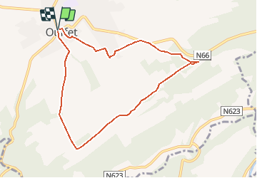
Trail Mountain bike of 7.7 km to be discovered at Wallonia, Liège, Ouffet. This trail is proposed by gk@icedd.be.
Description
Départ de la Grand Place par des rues typiquement condruziennes en pierres du pays.
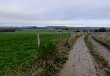
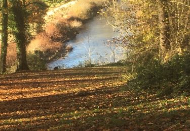
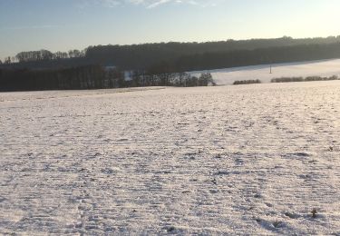
Très rapidement les randonneurs se dirigeront vers des champs, des prairies et des bois sur la quasi-totalité de la promenade.
Positioning
Country:
Belgium
Region :
Wallonia
Department/Province :
Liège
Municipality :
Ouffet
Location:
Ouffet
Start:(Dec)
Start:(UTM)
675016 ; 5590236 (31U) N.
Comments
Trails nearby
![Trail On foot Anthisnes - AS03 Boucle de Tolumont - Photo](https://media.geolcdn.com/t/375/260/ext.jpg?maxdim=2&url=https%3A%2F%2Fmedia.geolcdn.com%2Ff%2Fbb3be3cf-eddc-4622-8273-ff9944f2671c.jpg)
![On foot On foot](https://static1.geolcdn.com/sitytour/trail-icons/100.png)
AS03 Boucle de Tolumont
On foot
Medium
(1)
Anthisnes,
Wallonia,
Liège,
Belgium
![](/images/other/stat-length.png)
13.4 km | 17.6 km-effort
3h 20min
![](https://static1.geolcdn.com/siteimages/upload/files/16400158638029165_repeat_loop_refresh_sync_direction_icon.png)
Yes
![Trail Walking Ferrières - GG-Lu-15_Sy - Barvaux - Photo](https://media.geolcdn.com/t/375/260/ext.jpg?maxdim=2&url=https%3A%2F%2Fmedia.geolcdn.com%2Ff%2F4cf6fb9a-77d5-4c51-bb72-4b6ca6a27202.jpg)
![Walking Walking](https://static1.geolcdn.com/sitytour/trail-icons/101.png)
GG-Lu-15_Sy - Barvaux
Walking
Very difficult
(1)
Ferrières,
Wallonia,
Liège,
Belgium
![](/images/other/stat-length.png)
18.9 km | 26 km-effort
5h 58min
![](https://static1.geolcdn.com/siteimages/upload/files/16400158638029165_repeat_loop_refresh_sync_direction_icon.png)
No
![Trail Walking Anthisnes - Anthines - AS03 - Boucle de Tolumont - Losange Bleu - Photo](https://media.geolcdn.com/t/375/260/ext.jpg?maxdim=2&url=https%3A%2F%2Fmedia.geolcdn.com%2Ff%2Fa3413dfd-3361-4d9b-b91d-7efec18943a3.jpg)
![Walking Walking](https://static1.geolcdn.com/sitytour/trail-icons/101.png)
Anthines - AS03 - Boucle de Tolumont - Losange Bleu
Walking
Medium
(2)
Anthisnes,
Wallonia,
Liège,
Belgium
![](/images/other/stat-length.png)
13.9 km | 18.2 km-effort
2h 56min
![](https://static1.geolcdn.com/siteimages/upload/files/16400158638029165_repeat_loop_refresh_sync_direction_icon.png)
Yes
![Trail Walking Ouffet - Warzée - Photo](https://media.geolcdn.com/t/375/260/ext.jpg?maxdim=2&url=https%3A%2F%2Fmedia.geolcdn.com%2Ff%2F88310f1f-09c5-47f0-81d1-062b6f8d9e7b.JPG)
![Walking Walking](https://static1.geolcdn.com/sitytour/trail-icons/101.png)
![Trail Walking Ouffet - ouffet fermes ac + - Photo](https://media.geolcdn.com/t/375/260/ext.jpg?maxdim=2&url=https%3A%2F%2Fmedia.geolcdn.com%2Ff%2Ffd6ab0a5-da2e-4ec4-9fa1-96c42c21280a.jpg)
![Walking Walking](https://static1.geolcdn.com/sitytour/trail-icons/101.png)
ouffet fermes ac +
Walking
Medium
(2)
Ouffet,
Wallonia,
Liège,
Belgium
![](/images/other/stat-length.png)
8.6 km | 10.7 km-effort
2h 41min
![](https://static1.geolcdn.com/siteimages/upload/files/16400158638029165_repeat_loop_refresh_sync_direction_icon.png)
Yes
![Trail Walking Durbuy - Oneux ac - Photo](https://media.geolcdn.com/t/375/260/ext.jpg?maxdim=2&url=https%3A%2F%2Fmedia.geolcdn.com%2Ff%2F36c2cfa6-8fdc-4eba-8b2d-5fad9a9ffa94.jpg)
![Walking Walking](https://static1.geolcdn.com/sitytour/trail-icons/101.png)
Oneux ac
Walking
Medium
(1)
Durbuy,
Wallonia,
Luxembourg,
Belgium
![](/images/other/stat-length.png)
8.7 km | 11 km-effort
2h 21min
![](https://static1.geolcdn.com/siteimages/upload/files/16400158638029165_repeat_loop_refresh_sync_direction_icon.png)
Yes
![Trail Walking Hamoir - Hamoir adepstr - Photo](https://media.geolcdn.com/t/375/260/ext.jpg?maxdim=2&url=https%3A%2F%2Fmedia.geolcdn.com%2Ff%2Ff7c6aedd-db0e-4e45-9994-a9f8bea87367.jpg)
![Walking Walking](https://static1.geolcdn.com/sitytour/trail-icons/101.png)
Hamoir adepstr
Walking
Very difficult
(1)
Hamoir,
Wallonia,
Liège,
Belgium
![](/images/other/stat-length.png)
21 km | 26 km-effort
4h 23min
![](https://static1.geolcdn.com/siteimages/upload/files/16400158638029165_repeat_loop_refresh_sync_direction_icon.png)
Yes
![Trail Walking Anthisnes - départ du château de l'Avouerie d'Anthisnes - Photo](https://media.geolcdn.com/t/375/260/ext.jpg?maxdim=2&url=https%3A%2F%2Fservices.sitytrail.com%2FGeolivesWS%2FDownloadMedia.ashx%3FTrailID%3D688091%26Media%3D20170122160059.jpg)
![Walking Walking](https://static1.geolcdn.com/sitytour/trail-icons/101.png)
départ du château de l'Avouerie d'Anthisnes
Walking
Very easy
(1)
Anthisnes,
Wallonia,
Liège,
Belgium
![](/images/other/stat-length.png)
10.1 km | 12.4 km-effort
2h 48min
![](https://static1.geolcdn.com/siteimages/upload/files/16400158638029165_repeat_loop_refresh_sync_direction_icon.png)
Yes
![Trail Cycle Durbuy - La Dorsale - Photo](https://media.geolcdn.com/t/375/260/ext.jpg?maxdim=2&url=https%3A%2F%2Fservices.sitytrail.com%2FGeolivesWS%2FDownloadMedia.ashx%3FTrailID%3D134518%26Media%3De1c74f9b-ff8b-4f2d-859f-75e7649044ea.jpg)
![Cycle Cycle](https://static1.geolcdn.com/sitytour/trail-icons/200.png)