![](/images/other/stat-length.png)
![Trail Walking Manosque - Toutes-Aures en partant de Drouille - Photo](https://media.geolcdn.com/t/1900/400/ext.pjpeg?maxdim=2&url=https%3A%2F%2Fservices.sitytrail.com%2FGeolivesWS%2FDownloadMedia.ashx%3FTrailID%3D889502%26Media%3Dfix__20180118094350.jpg)
Toutes-Aures en partant de Drouille
liocol
User
![Length](/images/other/stat-length.png)
Length
6.3 km
![Max alt](https://static1.geolcdn.com/siteimages/upload/files/1508320355ic_sort_altitude_max_24dp.png)
Max alt
468 m
![Uphill gradient](https://static1.geolcdn.com/siteimages/upload/files/1508320355ic_sort_den_pos_24dp.png)
Uphill gradient
136 m
![Km-Effort](/images/other/stat-length.png)
Km-Effort
8.1 km
![Min alt](https://static1.geolcdn.com/siteimages/upload/files/1508320355ic_sort_altitude_min_24dp.png)
Min alt
345 m
![Downhill gradient](https://static1.geolcdn.com/siteimages/upload/files/1508320355ic_sort_den_neg_24dp.png)
Downhill gradient
136 m
![Boucle](https://static1.geolcdn.com/siteimages/upload/files/16400158638029165_repeat_loop_refresh_sync_direction_icon.png)
Boucle
Yes
Creation date :
2018-04-17 16:25:49.718
Updated on :
2018-04-17 16:25:49.718
![Walking](https://static1.geolcdn.com/sitytour/trail-icons/101.png)
1h48
Difficulty : Easy
![Scan this QR Code to open this trail in the SityTrail application](https://capi.geolives.com/qq0zvz2zws4bq2lad0pu/sitytour/trails/889502/qr.png?size=200)
FREE GPS app for hiking
About
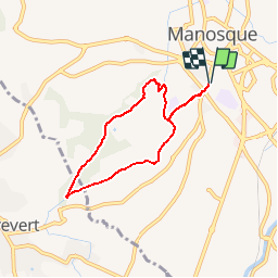
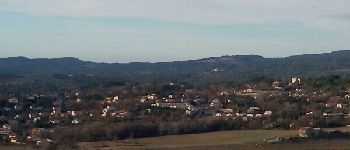
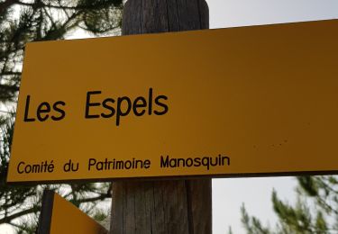
Trail Walking of 6.3 km to be discovered at Provence-Alpes-Côte d'Azur, Alpes-de-Haute-Provence, Manosque. This trail is proposed by liocol.
Description
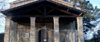
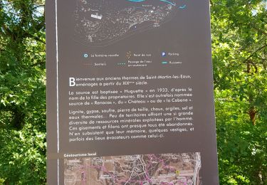
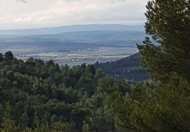
Garez vous sur le parking de Drouille, pas sur la rue, Zone bleue. Une boucle qui suit le canal, le GR et la Chapelle Toutes-Aures.
Positioning
Country:
France
Region :
Provence-Alpes-Côte d'Azur
Department/Province :
Alpes-de-Haute-Provence
Municipality :
Manosque
Location:
Unknown
Start:(Dec)
Start:(UTM)
723726 ; 4856544 (31T) N.
Comments
Trails nearby
![Trail Walking Manosque - Le Val des Chats, avant le col de la Mort d'Imbert. - Photo](https://media.geolcdn.com/t/375/260/ext.jpg?maxdim=2&url=https%3A%2F%2Fservices.sitytrail.com%2FGeolivesWS%2FDownloadMedia.ashx%3FTrailID%3D897794%26Media%3Dfix__20180202095306.jpg)
![Walking Walking](https://static1.geolcdn.com/sitytour/trail-icons/101.png)
Le Val des Chats, avant le col de la Mort d'Imbert.
Walking
Easy
(2)
Manosque,
Provence-Alpes-Côte d'Azur,
Alpes-de-Haute-Provence,
France
![](/images/other/stat-length.png)
4.7 km | 6.5 km-effort
1h 23min
![](https://static1.geolcdn.com/siteimages/upload/files/16400158638029165_repeat_loop_refresh_sync_direction_icon.png)
Yes
![Trail Walking Manosque - MANOSQUE VOLX PAR LES COLLINES O S - Photo](https://media.geolcdn.com/t/375/260/704cb0ab-321f-4c7d-8564-495e7eaa472c.jpg&format=jpg&maxdim=2)
![Walking Walking](https://static1.geolcdn.com/sitytour/trail-icons/101.png)
MANOSQUE VOLX PAR LES COLLINES O S
Walking
Difficult
Manosque,
Provence-Alpes-Côte d'Azur,
Alpes-de-Haute-Provence,
France
![](/images/other/stat-length.png)
17.7 km | 24 km-effort
4h 15min
![](https://static1.geolcdn.com/siteimages/upload/files/16400158638029165_repeat_loop_refresh_sync_direction_icon.png)
Yes
![Trail Mountain bike Volx - Volx/Montaigu/Bellevue/La Garde - Photo](https://media.geolcdn.com/t/375/260/ext.jpg?maxdim=2&url=https%3A%2F%2Fstatic1.geolcdn.com%2Fsiteimages%2Fupload%2Ffiles%2F1524743154velo.jpg)
![Mountain bike Mountain bike](https://static1.geolcdn.com/sitytour/trail-icons/202.png)
Volx/Montaigu/Bellevue/La Garde
Mountain bike
Medium
(1)
Volx,
Provence-Alpes-Côte d'Azur,
Alpes-de-Haute-Provence,
France
![](/images/other/stat-length.png)
16.2 km | 24 km-effort
1h 33min
![](https://static1.geolcdn.com/siteimages/upload/files/16400158638029165_repeat_loop_refresh_sync_direction_icon.png)
Yes
![Trail Walking Manosque - Le tour de la borie '' pain de sucre '' - Photo](https://media.geolcdn.com/t/375/260/ext.jpg?maxdim=2&url=https%3A%2F%2Fstatic1.geolcdn.com%2Fsiteimages%2Fupload%2Ffiles%2F1553511878bg_sport_marche.png)
![Walking Walking](https://static1.geolcdn.com/sitytour/trail-icons/101.png)
Le tour de la borie '' pain de sucre ''
Walking
Easy
(1)
Manosque,
Provence-Alpes-Côte d'Azur,
Alpes-de-Haute-Provence,
France
![](/images/other/stat-length.png)
5.1 km | 7.4 km-effort
1h 43min
![](https://static1.geolcdn.com/siteimages/upload/files/16400158638029165_repeat_loop_refresh_sync_direction_icon.png)
Yes
![Trail Walking Manosque - Quartier des Espels, départ Piscine. - Photo](https://media.geolcdn.com/t/375/260/ext.jpg?maxdim=2&url=https%3A%2F%2Fstatic1.geolcdn.com%2Fsiteimages%2Fupload%2Ffiles%2F1553511878bg_sport_marche.png)
![Walking Walking](https://static1.geolcdn.com/sitytour/trail-icons/101.png)
Quartier des Espels, départ Piscine.
Walking
Easy
(1)
Manosque,
Provence-Alpes-Côte d'Azur,
Alpes-de-Haute-Provence,
France
![](/images/other/stat-length.png)
4.8 km | 7.3 km-effort
1h 50min
![](https://static1.geolcdn.com/siteimages/upload/files/16400158638029165_repeat_loop_refresh_sync_direction_icon.png)
Yes
![Trail Trail Volx - volx - Photo](https://media.geolcdn.com/t/375/260/074b6f13-4b46-4d5f-9210-d6f66b960796.jpg&format=jpg&maxdim=2)
![Trail Trail](https://static1.geolcdn.com/sitytour/trail-icons/104.png)
volx
Trail
Difficult
Volx,
Provence-Alpes-Côte d'Azur,
Alpes-de-Haute-Provence,
France
![](/images/other/stat-length.png)
9.2 km | 14.7 km-effort
1h 43min
![](https://static1.geolcdn.com/siteimages/upload/files/16400158638029165_repeat_loop_refresh_sync_direction_icon.png)
Yes
![Trail Walking Manosque - 1Les speels, le relais, le pain de sucre. Depart Crématoriome. - Photo](https://media.geolcdn.com/t/375/260/6283877c-2ac3-4309-9701-717eb3cc7193.jpg&format=jpg&maxdim=2)
![Walking Walking](https://static1.geolcdn.com/sitytour/trail-icons/101.png)
1Les speels, le relais, le pain de sucre. Depart Crématoriome.
Walking
Medium
(1)
Manosque,
Provence-Alpes-Côte d'Azur,
Alpes-de-Haute-Provence,
France
![](/images/other/stat-length.png)
6.1 km | 9.7 km-effort
2h 4min
![](https://static1.geolcdn.com/siteimages/upload/files/16400158638029165_repeat_loop_refresh_sync_direction_icon.png)
Yes
![Trail Walking Saint-Martin-les-Eaux - 1Domaine de Bourne - Photo](https://media.geolcdn.com/t/375/260/80f6f537-be43-4ee4-a47d-fb6f1cabac0e.jpg&format=jpg&maxdim=2)
![Walking Walking](https://static1.geolcdn.com/sitytour/trail-icons/101.png)
1Domaine de Bourne
Walking
Medium
Saint-Martin-les-Eaux,
Provence-Alpes-Côte d'Azur,
Alpes-de-Haute-Provence,
France
![](/images/other/stat-length.png)
5.6 km | 8.3 km-effort
2h 2min
![](https://static1.geolcdn.com/siteimages/upload/files/16400158638029165_repeat_loop_refresh_sync_direction_icon.png)
Yes
![Trail Walking Manosque - 1Gaude, boucle de Montaigu. - Photo](https://media.geolcdn.com/t/375/260/13d3f8ee-c326-48e6-acf5-3d3f5fa0e4c9.jpg&format=jpg&maxdim=2)
![Walking Walking](https://static1.geolcdn.com/sitytour/trail-icons/101.png)
1Gaude, boucle de Montaigu.
Walking
Medium
Manosque,
Provence-Alpes-Côte d'Azur,
Alpes-de-Haute-Provence,
France
![](/images/other/stat-length.png)
6.6 km | 10.2 km-effort
2h 7min
![](https://static1.geolcdn.com/siteimages/upload/files/16400158638029165_repeat_loop_refresh_sync_direction_icon.png)
Yes