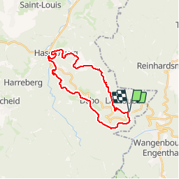
![](/images/other/stat-length.png)
![Trail Walking Dabo - 67 La Hoube Haselbourg - Photo](https://media.geolcdn.com/t/1900/400/ext.pjpeg?maxdim=2&url=https%3A%2F%2Fservices.sitytrail.com%2FGeolivesWS%2FDownloadMedia.ashx%3FTrailID%3D885850%26Media%3Dfix__20180111154458.jpg)
67 La Hoube Haselbourg
LUTZMarc
User
![Length](/images/other/stat-length.png)
![Max alt](https://static1.geolcdn.com/siteimages/upload/files/1508320355ic_sort_altitude_max_24dp.png)
![Uphill gradient](https://static1.geolcdn.com/siteimages/upload/files/1508320355ic_sort_den_pos_24dp.png)
![Km-Effort](/images/other/stat-length.png)
![Min alt](https://static1.geolcdn.com/siteimages/upload/files/1508320355ic_sort_altitude_min_24dp.png)
![Downhill gradient](https://static1.geolcdn.com/siteimages/upload/files/1508320355ic_sort_den_neg_24dp.png)
![Boucle](https://static1.geolcdn.com/siteimages/upload/files/16400158638029165_repeat_loop_refresh_sync_direction_icon.png)
![Walking](https://static1.geolcdn.com/sitytour/trail-icons/101.png)
5h33
Difficulty : Medium
![Scan this QR Code to open this trail in the SityTrail application](https://capi.geolives.com/qq0zvz2zws4bq2lad0pu/sitytour/trails/885850/qr.png?size=200)
FREE GPS app for hiking
About
Trail Walking of 24 km to be discovered at Grand Est, Moselle, Dabo. This trail is proposed by LUTZMarc.
Description
Belle rando sur chemin sablonneux.
Repas au resto chez Schreiber à Haselbourg. Super plat du jour en semaine, réservation conseillée.
Il faut compter 3 h30 pour arriver au resto. Les difficultés sont sur le chemin du retour avec des montées longues et des portions de pentes sévères.
Positioning
Comments
Trails nearby
![Trail Walking Reinhardsmunster - 2021-09-01 Marche Reinhardsmunster Haut Barr - Photo](https://media.geolcdn.com/t/375/260/266b2ac9-dd10-4dc7-a762-c9d36720cc88.jpg&format=jpg&maxdim=2)
![Walking Walking](https://static1.geolcdn.com/sitytour/trail-icons/101.png)
Walking
![](/images/other/stat-length.png)
![](https://static1.geolcdn.com/siteimages/upload/files/16400158638029165_repeat_loop_refresh_sync_direction_icon.png)
![Trail Walking Reinhardsmunster - 2020-06-13 Marche Ditschelkopf Schweizerberg - Photo](https://media.geolcdn.com/t/375/260/d6670ae9-2bf3-459d-a4b8-1c117627d287.jpg&format=jpg&maxdim=2)
![Walking Walking](https://static1.geolcdn.com/sitytour/trail-icons/101.png)
Walking
![](/images/other/stat-length.png)
![](https://static1.geolcdn.com/siteimages/upload/files/16400158638029165_repeat_loop_refresh_sync_direction_icon.png)
![Trail Walking Wangenbourg-Engenthal - 2020-03-14 Marche Engenthal le bas - Photo](https://media.geolcdn.com/t/375/260/ba70735c-7023-4458-a456-f43a6f2e7606.jpg&format=jpg&maxdim=2)
![Walking Walking](https://static1.geolcdn.com/sitytour/trail-icons/101.png)
Walking
![](/images/other/stat-length.png)
![](https://static1.geolcdn.com/siteimages/upload/files/16400158638029165_repeat_loop_refresh_sync_direction_icon.png)
![Trail Walking Wangenbourg-Engenthal - 2019-11-16 Marche Wangenbourg Castelberg - Photo](https://media.geolcdn.com/t/375/260/5fe565fb-6e88-4bed-a889-a75a33bb061a.jpg&format=jpg&maxdim=2)
![Walking Walking](https://static1.geolcdn.com/sitytour/trail-icons/101.png)
Walking
![](/images/other/stat-length.png)
![](https://static1.geolcdn.com/siteimages/upload/files/16400158638029165_repeat_loop_refresh_sync_direction_icon.png)
![Trail Walking Wangenbourg-Engenthal - 2017-02-24 Marche Schneeberg - Photo](https://media.geolcdn.com/t/375/260/ext.jpg?maxdim=2&url=https%3A%2F%2Fstatic1.geolcdn.com%2Fsiteimages%2Fupload%2Ffiles%2F1553511878bg_sport_marche.png)
![Walking Walking](https://static1.geolcdn.com/sitytour/trail-icons/101.png)
Walking
![](/images/other/stat-length.png)
![](https://static1.geolcdn.com/siteimages/upload/files/16400158638029165_repeat_loop_refresh_sync_direction_icon.png)
![Trail Mountain bike Dabo - Balcon de Dabo 2010 - Photo](https://media.geolcdn.com/t/375/260/ext.jpg?maxdim=2&url=https%3A%2F%2Fstatic1.geolcdn.com%2Fsiteimages%2Fupload%2Ffiles%2F1524743154velo.jpg)
![Mountain bike Mountain bike](https://static1.geolcdn.com/sitytour/trail-icons/202.png)
Mountain bike
![](/images/other/stat-length.png)
![](https://static1.geolcdn.com/siteimages/upload/files/16400158638029165_repeat_loop_refresh_sync_direction_icon.png)
![Trail Walking Wangenbourg-Engenthal - obersteigen - Photo](https://media.geolcdn.com/t/375/260/1627429b-7fff-427f-af0e-c37d2da3b0ec.jpg&format=jpg&maxdim=2)
![Walking Walking](https://static1.geolcdn.com/sitytour/trail-icons/101.png)
Walking
![](/images/other/stat-length.png)
![](https://static1.geolcdn.com/siteimages/upload/files/16400158638029165_repeat_loop_refresh_sync_direction_icon.png)
![Trail Horseback riding Dabo - Tour de dabo Tivio Joyeux - Photo](https://media.geolcdn.com/t/375/260/76dac64e-0da6-4de1-a424-f40eae7e5699.jpg&format=jpg&maxdim=2)
![Horseback riding Horseback riding](https://static1.geolcdn.com/sitytour/trail-icons/301.png)
Horseback riding
![](/images/other/stat-length.png)
![](https://static1.geolcdn.com/siteimages/upload/files/16400158638029165_repeat_loop_refresh_sync_direction_icon.png)
![Trail Walking Wangenbourg-Engenthal - ARCA WANGENBOURG - Photo](https://media.geolcdn.com/t/375/260/8387777e-0af4-46e8-976a-a6425ad883f8.jpg&format=jpg&maxdim=2)
![Walking Walking](https://static1.geolcdn.com/sitytour/trail-icons/101.png)
Walking
![](/images/other/stat-length.png)
![](https://static1.geolcdn.com/siteimages/upload/files/16400158638029165_repeat_loop_refresh_sync_direction_icon.png)