Trail Walking Montet-et-Bouxal - Ste Colombe - Moulin de Pétarot - Photo

Ste Colombe - Moulin de Pétarot

 goutal
goutal

User

© OpenStreetMap contributors
Length
Length
10.1 km
Max alt
Max alt
614 m
Uphill gradient
Uphill gradient
243 m
Km-Effort
Km-Effort  
13.3 km
Min alt
Min alt
460 m
Downhill gradient
Downhill gradient
240 m
Boucle
Boucle
Yes
Creation date :
2018-04-17 15:49:31.312
Updated on :
2018-04-17 15:49:31.312

(0 Reviews)

Walking
Walking
2h50
Difficulty : Easy

Scan this QR Code to open this trail in the SityTrail application

FREE GPS app for hiking

Logo SityTrail SityTrail

IGN / Geographical institutes

Download SityTrail from the App Store Download SityTrail from Google Play

Logo SityTrail SityTrail World

The world is yours!

Download SityTrail from the App Store Download SityTrail from Google Play Download SityTrail on Huawei AppGallery

About

Trail Walking of 10.1 km to be discovered at Occitania, Lot, Montet-et-Bouxal. This trail is proposed by goutal.

Description

Départ sur la pace de Lavitarele vers Rouqueyroux, Ste Colombe, Les Vergnes, Moulin de Pétarot e retour vers Lacompostie, Latreille et arrivée à Lavitarelle.

Elevation profile

Positioning

Country:
France
Region :
Occitania
Department/Province :
Lot
Municipality :
Montet-et-Bouxal
Location:
Unknown
Start:(UTM)
422333 ; 4954573 (31T) N.

Trails nearby

Trail Walking Terrou - Terrou2 - Photo
Walking
thomas.o.vert

Walking

Medium
Terrou, Occitania, Lot, France
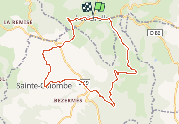
14.5 km | 20 km-effort
3h 46min
Yes
Trail Walking Sabadel-Latronquière - gouffre dès cloches - Photo
Walking
thomas.o.vert

Walking

Difficult
Sabadel-Latronquière, Occitania, Lot, France
4.9 km | 7.2 km-effort
2h 35min
No
Trail Walking Montet-et-Bouxal - la vitarelle  - Photo
Walking
gcournac

Walking

Very difficult
Montet-et-Bouxal, Occitania, Lot, France
16 km | 22 km-effort
4h 17min
Yes
Trail Walking Saint-Perdoux - mines du Soulié - Photo
Walking
thomas.o.vert

Walking

Easy
Saint-Perdoux, Occitania, Lot, France
2.8 km | 3.7 km-effort
45min
Yes
Trail Nordic walking Sabadel-Latronquière - monter et bouxal - Photo
Nordic walking
thomas.o.vert

Nordic walking

Medium
Sabadel-Latronquière, Occitania, Lot, France
14.4 km | 20 km-effort
3h 37min
Yes
Trail Road bike Sainte-Colombe - Rénac plage - Photo
Road bike
goutal

Road bike

Very difficult
Sainte-Colombe, Occitania, Lot, France
47 km | 58 km-effort
3h 19min
No
Trail Walking Terrou - 5 Terrou Annie 24-05-2018 - Photo
Walking
ZAMBAUX

Walking

Medium
Terrou, Occitania, Lot, France
6.5 km | 8.8 km-effort
1h 52min
Yes
Trail Walking Terrou - TOLERME   14.4 km - Photo
Walking
ZAMBAUX

Walking

Very difficult
Terrou, Occitania, Lot, France
14.4 km | 20 km-effort
4h 23min
No
Trail Walking Terrou - TERROU   9.1 km - Photo
Walking
ZAMBAUX

Walking

Difficult
Terrou, Occitania, Lot, France
9.1 km | 13.8 km-effort
2h 52min
Yes


Close
My subscriptions