![](/images/other/stat-length.png)
![Trail Mountain bike Florac Trois Rivières - Boucle Florac défi Mont Aigoual.gpx - Photo](https://media.geolcdn.com/t/1900/400/ext.pjpeg?maxdim=2&url=https%3A%2F%2Fstatic1.geolcdn.com%2Fsiteimages%2Fupload%2Ffiles%2F1524743154velo.jpg)
Boucle Florac défi Mont Aigoual.gpx
J-Mi
User
![Length](/images/other/stat-length.png)
Length
119 km
![Max alt](https://static1.geolcdn.com/siteimages/upload/files/1508320355ic_sort_altitude_max_24dp.png)
Max alt
1561 m
![Uphill gradient](https://static1.geolcdn.com/siteimages/upload/files/1508320355ic_sort_den_pos_24dp.png)
Uphill gradient
3305 m
![Km-Effort](/images/other/stat-length.png)
Km-Effort
163 km
![Min alt](https://static1.geolcdn.com/siteimages/upload/files/1508320355ic_sort_altitude_min_24dp.png)
Min alt
545 m
![Downhill gradient](https://static1.geolcdn.com/siteimages/upload/files/1508320355ic_sort_den_neg_24dp.png)
Downhill gradient
3305 m
![Boucle](https://static1.geolcdn.com/siteimages/upload/files/16400158638029165_repeat_loop_refresh_sync_direction_icon.png)
Boucle
Yes
Creation date :
2018-04-17 15:26:53.161
Updated on :
2018-04-17 15:26:53.161
![Mountain bike](https://static1.geolcdn.com/sitytour/trail-icons/202.png)
8h20
Difficulty : Difficult
![Scan this QR Code to open this trail in the SityTrail application](https://capi.geolives.com/qq0zvz2zws4bq2lad0pu/sitytour/trails/881935/qr.png?size=200)
FREE GPS app for hiking
About
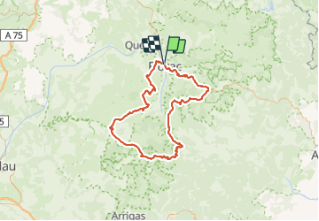
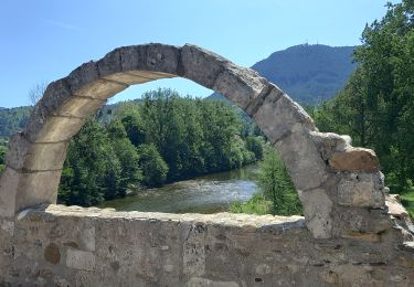
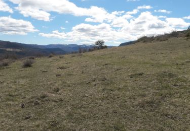
Trail Mountain bike of 119 km to be discovered at Occitania, Lozère, Florac Trois Rivières. This trail is proposed by J-Mi.
Description
J'ai effectué ce tracé en Aout 2017 belle balade sur une grosse journée de VTT. Possibilité de couper en deux jours hébergement à la maison forestière d'aire de côte. Bon raid J-Michel
Positioning
Country:
France
Region :
Occitania
Department/Province :
Lozère
Municipality :
Florac Trois Rivières
Location:
Florac
Start:(Dec)
Start:(UTM)
547259 ; 4908421 (31T) N.
Comments
Trails nearby
![Trail Walking Florac Trois Rivières - Le Sentier des Couronnes - Florac - Photo](https://media.geolcdn.com/t/375/260/ext.jpg?maxdim=2&url=https%3A%2F%2Fservices.sitytrail.com%2FGeolivesWS%2FDownloadMedia.ashx%3FTrailID%3D129855%26Media%3D13413_6.jpg)
![Walking Walking](https://static1.geolcdn.com/sitytour/trail-icons/101.png)
Le Sentier des Couronnes - Florac
Walking
Difficult
(4)
Florac Trois Rivières,
Occitania,
Lozère,
France
![](/images/other/stat-length.png)
15.3 km | 24 km-effort
5h 0min
![](https://static1.geolcdn.com/siteimages/upload/files/16400158638029165_repeat_loop_refresh_sync_direction_icon.png)
Yes
![Trail Walking Bédouès-Cocurès - Stevenson Bedouès Barre des Cévennes - Photo](https://media.geolcdn.com/t/375/260/86b0857f-5630-4b37-8494-7a00373be256.jpg&format=jpg&maxdim=2)
![Walking Walking](https://static1.geolcdn.com/sitytour/trail-icons/101.png)
Stevenson Bedouès Barre des Cévennes
Walking
Difficult
Bédouès-Cocurès,
Occitania,
Lozère,
France
![](/images/other/stat-length.png)
20 km | 28 km-effort
6h 4min
![](https://static1.geolcdn.com/siteimages/upload/files/16400158638029165_repeat_loop_refresh_sync_direction_icon.png)
No
![Trail On foot Florac Trois Rivières - Florac - Photo](https://media.geolcdn.com/t/375/260/f2a77ee2-7a86-4802-91d2-226710ca6f1c.jpeg&format=jpg&maxdim=2)
![On foot On foot](https://static1.geolcdn.com/sitytour/trail-icons/100.png)
Florac
On foot
Medium
Florac Trois Rivières,
Occitania,
Lozère,
France
![](/images/other/stat-length.png)
15.5 km | 24 km-effort
5h 30min
![](https://static1.geolcdn.com/siteimages/upload/files/16400158638029165_repeat_loop_refresh_sync_direction_icon.png)
Yes
![Trail Walking Florac Trois Rivières - Panoramique des couronnes - Photo](https://media.geolcdn.com/t/375/260/7019c90e-f046-4f38-8c65-fb0ab66f3f22.jpg&format=jpg&maxdim=2)
![Walking Walking](https://static1.geolcdn.com/sitytour/trail-icons/101.png)
Panoramique des couronnes
Walking
Difficult
Florac Trois Rivières,
Occitania,
Lozère,
France
![](/images/other/stat-length.png)
14.9 km | 23 km-effort
5h 43min
![](https://static1.geolcdn.com/siteimages/upload/files/16400158638029165_repeat_loop_refresh_sync_direction_icon.png)
Yes
![Trail Walking Florac Trois Rivières - Les Cévennes sentiers sympas - Photo](https://media.geolcdn.com/t/375/260/39fe67cd-54e7-4946-b242-3ad32b0a4775.jpg&format=jpg&maxdim=2)
![Walking Walking](https://static1.geolcdn.com/sitytour/trail-icons/101.png)
Les Cévennes sentiers sympas
Walking
Medium
Florac Trois Rivières,
Occitania,
Lozère,
France
![](/images/other/stat-length.png)
7.2 km | 11.6 km-effort
2h 43min
![](https://static1.geolcdn.com/siteimages/upload/files/16400158638029165_repeat_loop_refresh_sync_direction_icon.png)
Yes
![Trail Walking Florac Trois Rivières - Etape 8 Florac/Cassagnas - Photo](https://media.geolcdn.com/t/375/260/495f7742-b660-4cb5-bdb0-98f953d0eda5.jpg&format=jpg&maxdim=2)
![Walking Walking](https://static1.geolcdn.com/sitytour/trail-icons/101.png)
Etape 8 Florac/Cassagnas
Walking
Medium
Florac Trois Rivières,
Occitania,
Lozère,
France
![](/images/other/stat-length.png)
20 km | 26 km-effort
5h 20min
![](https://static1.geolcdn.com/siteimages/upload/files/16400158638029165_repeat_loop_refresh_sync_direction_icon.png)
No
![Trail Walking Bédouès-Cocurès - 14-05-2023 E9 Bédouès - Barre des Cévennes - Photo](https://media.geolcdn.com/t/375/260/c49eac84-f99f-43af-9f22-014089784d72.jpg&format=jpg&maxdim=2)
![Walking Walking](https://static1.geolcdn.com/sitytour/trail-icons/101.png)
14-05-2023 E9 Bédouès - Barre des Cévennes
Walking
Very difficult
Bédouès-Cocurès,
Occitania,
Lozère,
France
![](/images/other/stat-length.png)
19.6 km | 27 km-effort
6h 11min
![](https://static1.geolcdn.com/siteimages/upload/files/16400158638029165_repeat_loop_refresh_sync_direction_icon.png)
No
![Trail Walking Florac Trois Rivières - de Florac à St Enimie par le Causse de Sauveterre - Photo](https://media.geolcdn.com/t/375/260/166b8a72-b2d0-4c55-bf4e-bd92beaeab4e.jpg&format=jpg&maxdim=2)
![Walking Walking](https://static1.geolcdn.com/sitytour/trail-icons/101.png)
de Florac à St Enimie par le Causse de Sauveterre
Walking
Very difficult
Florac Trois Rivières,
Occitania,
Lozère,
France
![](/images/other/stat-length.png)
27 km | 41 km-effort
9h 26min
![](https://static1.geolcdn.com/siteimages/upload/files/16400158638029165_repeat_loop_refresh_sync_direction_icon.png)
No
![Trail Walking Cans et Cévennes - Autour du MAZEL via CROUPILLAC - Photo](https://media.geolcdn.com/t/375/260/da1b2bb7-b6ce-4ec8-b0ac-b09162e24a8f.jpg&format=jpg&maxdim=2)
![Walking Walking](https://static1.geolcdn.com/sitytour/trail-icons/101.png)
Autour du MAZEL via CROUPILLAC
Walking
Medium
Cans et Cévennes,
Occitania,
Lozère,
France
![](/images/other/stat-length.png)
4.2 km | 6.5 km-effort
1h 48min
![](https://static1.geolcdn.com/siteimages/upload/files/16400158638029165_repeat_loop_refresh_sync_direction_icon.png)
Yes