![](/images/other/stat-length.png)
![Trail Cycle Bailleul - Le Seau Boeseghem par Merville et Haverskerque - Photo](https://media.geolcdn.com/t/1900/400/ext.pjpeg?maxdim=2&url=https%3A%2F%2Fstatic1.geolcdn.com%2Fsiteimages%2Fupload%2Ffiles%2F1524743154velo.jpg)
Le Seau Boeseghem par Merville et Haverskerque
Domi1953
User
![Length](/images/other/stat-length.png)
Length
67 km
![Max alt](https://static1.geolcdn.com/siteimages/upload/files/1508320355ic_sort_altitude_max_24dp.png)
Max alt
42 m
![Uphill gradient](https://static1.geolcdn.com/siteimages/upload/files/1508320355ic_sort_den_pos_24dp.png)
Uphill gradient
250 m
![Km-Effort](/images/other/stat-length.png)
Km-Effort
70 km
![Min alt](https://static1.geolcdn.com/siteimages/upload/files/1508320355ic_sort_altitude_min_24dp.png)
Min alt
13 m
![Downhill gradient](https://static1.geolcdn.com/siteimages/upload/files/1508320355ic_sort_den_neg_24dp.png)
Downhill gradient
248 m
![Boucle](https://static1.geolcdn.com/siteimages/upload/files/16400158638029165_repeat_loop_refresh_sync_direction_icon.png)
Boucle
No
Creation date :
2019-01-09 17:57:23.992
Updated on :
2019-01-09 17:57:24.181
![Cycle](https://static1.geolcdn.com/sitytour/trail-icons/200.png)
4h06
Difficulty : Easy
![Scan this QR Code to open this trail in the SityTrail application](https://capi.geolives.com/qq0zvz2zws4bq2lad0pu/sitytour/trails/881680/qr.png?size=200)
FREE GPS app for hiking
About
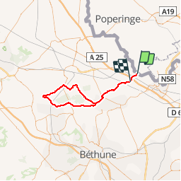
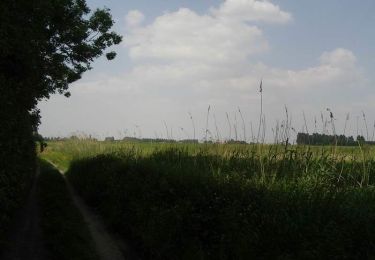
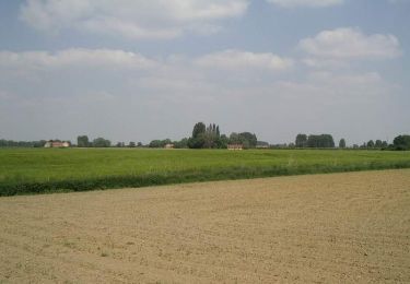
Trail Cycle of 67 km to be discovered at Hauts-de-France, Nord, Bailleul. This trail is proposed by Domi1953.
Description
Le Seau - Steenwerck -Le Doulieu - Neuf Berquin - Merville - Haverskerque - Thiennes - Boëseghem - Steenbecque -Morbecque - Motte au Bois - Caudescure - Merville -
Positioning
Country:
France
Region :
Hauts-de-France
Department/Province :
Nord
Municipality :
Bailleul
Location:
Unknown
Start:(Dec)
Start:(UTM)
486002 ; 5618623 (31U) N.
Comments
Trails nearby
![Trail On foot Heuvelland - Geuzen wandelroute - Photo](https://media.geolcdn.com/t/375/260/a748d58f-6dfe-4ad8-b887-8505015b63cc.jpeg&format=jpg&maxdim=2)
![On foot On foot](https://static1.geolcdn.com/sitytour/trail-icons/100.png)
Geuzen wandelroute
On foot
Easy
Heuvelland,
Flanders,
West Flanders,
Belgium
![](/images/other/stat-length.png)
9.7 km | 11.4 km-effort
2h 35min
![](https://static1.geolcdn.com/siteimages/upload/files/16400158638029165_repeat_loop_refresh_sync_direction_icon.png)
Yes
![Trail Motor Bailleul - 104 - Photo](https://media.geolcdn.com/t/375/260/ext.jpg?maxdim=2&url=https%3A%2F%2Fstatic1.geolcdn.com%2Fsiteimages%2Fupload%2Ffiles%2F15247431544x4.jpg)
![Motor Motor](https://static1.geolcdn.com/sitytour/trail-icons/400.png)
![Trail Walking Bailleul - camping de la Ferme des Saules à côté de Bailleul, arrivée Deulemont - Photo](https://media.geolcdn.com/t/375/260/5dfd3b71-bc9e-42e1-b3be-5ab9c2cf49ac.jpg&format=jpg&maxdim=2)
![Walking Walking](https://static1.geolcdn.com/sitytour/trail-icons/101.png)
camping de la Ferme des Saules à côté de Bailleul, arrivée Deulemont
Walking
Medium
Bailleul,
Hauts-de-France,
Nord,
France
![](/images/other/stat-length.png)
32 km | 34 km-effort
9h 10min
![](https://static1.geolcdn.com/siteimages/upload/files/16400158638029165_repeat_loop_refresh_sync_direction_icon.png)
No
![Trail Walking Heuvelland - Nieuwekerke Bailleul 17,5 km - Photo](https://media.geolcdn.com/t/375/260/9e8e5b67-08f2-434d-8359-01cf5462426a.jpg&format=jpg&maxdim=2)
![Walking Walking](https://static1.geolcdn.com/sitytour/trail-icons/101.png)
Nieuwekerke Bailleul 17,5 km
Walking
Medium
Heuvelland,
Flanders,
West Flanders,
Belgium
![](/images/other/stat-length.png)
18.7 km | 21 km-effort
4h 53min
![](https://static1.geolcdn.com/siteimages/upload/files/16400158638029165_repeat_loop_refresh_sync_direction_icon.png)
Yes
![Trail Running Bailleul - bailleul - Photo](https://media.geolcdn.com/t/375/260/ext.jpg?maxdim=2&url=https%3A%2F%2Fservices.sitytrail.com%2FGeolivesWS%2FDownloadMedia.ashx%3FTrailID%3D194142%26Media%3D20130526085924.jpeg)
![Running Running](https://static1.geolcdn.com/sitytour/trail-icons/103.png)
![Trail Walking Bailleul - Sentier du Ravensberg - Bailleul - Photo](https://media.geolcdn.com/t/375/260/ext.jpg?maxdim=2&url=https%3A%2F%2Fservices.sitytrail.com%2FGeolivesWS%2FDownloadMedia.ashx%3FTrailID%3D111185%26Media%3D6663_6.jpg)
![Walking Walking](https://static1.geolcdn.com/sitytour/trail-icons/101.png)
Sentier du Ravensberg - Bailleul
Walking
Difficult
Bailleul,
Hauts-de-France,
Nord,
France
![](/images/other/stat-length.png)
14.4 km | 16.8 km-effort
3h 40min
![](https://static1.geolcdn.com/siteimages/upload/files/16400158638029165_repeat_loop_refresh_sync_direction_icon.png)
Yes
![Trail Walking Nieppe - De Nieppe à la Lys - Photo](https://media.geolcdn.com/t/375/260/ext.jpg?maxdim=2&url=https%3A%2F%2Fservices.sitytrail.com%2FGeolivesWS%2FDownloadMedia.ashx%3FTrailID%3D109307%26Media%3D3543_6.jpg)
![Walking Walking](https://static1.geolcdn.com/sitytour/trail-icons/101.png)
De Nieppe à la Lys
Walking
Easy
Nieppe,
Hauts-de-France,
Nord,
France
![](/images/other/stat-length.png)
8.2 km | 8.6 km-effort
2h 0min
![](https://static1.geolcdn.com/siteimages/upload/files/16400158638029165_repeat_loop_refresh_sync_direction_icon.png)
Yes
![Trail Walking Steenwerck - Promenade en bord de Lys - Steenwerck - Photo](https://media.geolcdn.com/t/375/260/ext.jpg?maxdim=2&url=https%3A%2F%2Fservices.sitytrail.com%2FGeolivesWS%2FDownloadMedia.ashx%3FTrailID%3D109088%26Media%3D3137_6.jpg)
![Walking Walking](https://static1.geolcdn.com/sitytour/trail-icons/101.png)
Promenade en bord de Lys - Steenwerck
Walking
Easy
(2)
Steenwerck,
Hauts-de-France,
Nord,
France
![](/images/other/stat-length.png)
4.7 km | 4.9 km-effort
1h 15min
![](https://static1.geolcdn.com/siteimages/upload/files/16400158638029165_repeat_loop_refresh_sync_direction_icon.png)
Yes
![Trail Walking Steenwerck - Circuit de la Boudrelle - Steenwerck - Photo](https://media.geolcdn.com/t/375/260/ext.jpg?maxdim=2&url=https%3A%2F%2Fservices.sitytrail.com%2FGeolivesWS%2FDownloadMedia.ashx%3FTrailID%3D109087%26Media%3D3136_6.jpg)
![Walking Walking](https://static1.geolcdn.com/sitytour/trail-icons/101.png)
Circuit de la Boudrelle - Steenwerck
Walking
Difficult
Steenwerck,
Hauts-de-France,
Nord,
France
![](/images/other/stat-length.png)
12.9 km | 13.4 km-effort
3h 15min
![](https://static1.geolcdn.com/siteimages/upload/files/16400158638029165_repeat_loop_refresh_sync_direction_icon.png)
Yes