![](/images/other/stat-length.png)
![Trail Walking Bagnoles-de-l'Orne-Normandie - Bagnoles-Couterne aux confins de la Normandie - Photo](https://media.geolcdn.com/t/1900/400/ext.pjpeg?maxdim=2&url=https%3A%2F%2Fstatic1.geolcdn.com%2Fsiteimages%2Fupload%2Ffiles%2F1553511878bg_sport_marche.png)
Bagnoles-Couterne aux confins de la Normandie
toporient
User
![Length](/images/other/stat-length.png)
Length
13.8 km
![Max alt](https://static1.geolcdn.com/siteimages/upload/files/1508320355ic_sort_altitude_max_24dp.png)
Max alt
229 m
![Uphill gradient](https://static1.geolcdn.com/siteimages/upload/files/1508320355ic_sort_den_pos_24dp.png)
Uphill gradient
233 m
![Km-Effort](/images/other/stat-length.png)
Km-Effort
16.9 km
![Min alt](https://static1.geolcdn.com/siteimages/upload/files/1508320355ic_sort_altitude_min_24dp.png)
Min alt
121 m
![Downhill gradient](https://static1.geolcdn.com/siteimages/upload/files/1508320355ic_sort_den_neg_24dp.png)
Downhill gradient
233 m
![Boucle](https://static1.geolcdn.com/siteimages/upload/files/16400158638029165_repeat_loop_refresh_sync_direction_icon.png)
Boucle
Yes
Creation date :
2018-04-17 14:57:18.246
Updated on :
2018-04-17 14:57:18.246
![Walking](https://static1.geolcdn.com/sitytour/trail-icons/101.png)
3h39
Difficulty : Medium
![Scan this QR Code to open this trail in the SityTrail application](https://capi.geolives.com/qq0zvz2zws4bq2lad0pu/sitytour/trails/878271/qr.png?size=200)
FREE GPS app for hiking
About
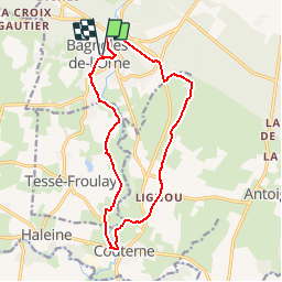
Trail Walking of 13.8 km to be discovered at Normandy, Orne, Bagnoles-de-l'Orne-Normandie. This trail is proposed by toporient.
Description
Du château, le circuit passe par le lac puis par le vieux Bagnoles. Il rejoint ensuite le GRP jusqu'à ND de Lignou et Couterne puis revient par la vallée de la Vée et le vieux Tessé pour terminer au château.
Positioning
Country:
France
Region :
Normandy
Department/Province :
Orne
Municipality :
Bagnoles-de-l'Orne-Normandie
Location:
Bagnoles-de-l'Orne
Start:(Dec)
Start:(UTM)
690249 ; 5381036 (30U) N.
Comments
Trails nearby
![Trail On foot Rives-d'Andaine - Sentier des Templiers - Photo](https://media.geolcdn.com/t/375/260/ext.jpg?maxdim=2&url=https%3A%2F%2Fmedia.geolcdn.com%2Ff%2F7f8f2913-590f-4c31-b4e9-64954dd46906.jpeg)
![On foot On foot](https://static1.geolcdn.com/sitytour/trail-icons/100.png)
Sentier des Templiers
On foot
Easy
Rives-d'Andaine,
Normandy,
Orne,
France
![](/images/other/stat-length.png)
4.9 km | 6.2 km-effort
1h 23min
![](https://static1.geolcdn.com/siteimages/upload/files/16400158638029165_repeat_loop_refresh_sync_direction_icon.png)
No
![Trail Walking Bagnoles-de-l'Orne-Normandie - Saint Ortaire - Photo](https://media.geolcdn.com/t/375/260/ext.jpg?maxdim=2&url=https%3A%2F%2Fstatic1.geolcdn.com%2Fsiteimages%2Fupload%2Ffiles%2F1553511878bg_sport_marche.png)
![Walking Walking](https://static1.geolcdn.com/sitytour/trail-icons/101.png)
Saint Ortaire
Walking
Difficult
(1)
Bagnoles-de-l'Orne-Normandie,
Normandy,
Orne,
France
![](/images/other/stat-length.png)
5.5 km | 6.9 km-effort
1h 39min
![](https://static1.geolcdn.com/siteimages/upload/files/16400158638029165_repeat_loop_refresh_sync_direction_icon.png)
Yes
![Trail Walking Bagnoles-de-l'Orne-Normandie - Forêt d'Andaine - Photo](https://media.geolcdn.com/t/375/260/ext.jpg?maxdim=2&url=https%3A%2F%2Fmedia.geolcdn.com%2Ff%2F4445009f-5e34-4cf0-9270-1184d385e215.jpg)
![Walking Walking](https://static1.geolcdn.com/sitytour/trail-icons/101.png)
Forêt d'Andaine
Walking
Easy
Bagnoles-de-l'Orne-Normandie,
Normandy,
Orne,
France
![](/images/other/stat-length.png)
3.6 km | 4.2 km-effort
2h 0min
![](https://static1.geolcdn.com/siteimages/upload/files/16400158638029165_repeat_loop_refresh_sync_direction_icon.png)
No
![Trail On foot Bagnoles-de-l'Orne-Normandie - Les Arbres remarquables de Bagnoles-de-l'Orne - Photo](https://media.geolcdn.com/t/375/260/ext.jpg?maxdim=2&url=https%3A%2F%2Fmedia.geolcdn.com%2Ff%2F3f5af4f6-b5c2-468d-a381-1ea1dcd7f8d4.jpeg)
![On foot On foot](https://static1.geolcdn.com/sitytour/trail-icons/100.png)
Les Arbres remarquables de Bagnoles-de-l'Orne
On foot
Easy
Bagnoles-de-l'Orne-Normandie,
Normandy,
Orne,
France
![](/images/other/stat-length.png)
7.7 km | 9 km-effort
2h 2min
![](https://static1.geolcdn.com/siteimages/upload/files/16400158638029165_repeat_loop_refresh_sync_direction_icon.png)
Yes
![Trail On foot Bagnoles-de-l'Orne-Normandie - Bagnoles-de-l'Orne - Photo](https://media.geolcdn.com/t/375/260/ext.jpg?maxdim=2&url=https%3A%2F%2Fmedia.geolcdn.com%2Ff%2F352c0479-80dd-4a7d-ade5-52d7e1895bb3.jpeg)
![On foot On foot](https://static1.geolcdn.com/sitytour/trail-icons/100.png)
Bagnoles-de-l'Orne
On foot
Easy
Bagnoles-de-l'Orne-Normandie,
Normandy,
Orne,
France
![](/images/other/stat-length.png)
8.2 km | 9.7 km-effort
2h 11min
![](https://static1.geolcdn.com/siteimages/upload/files/16400158638029165_repeat_loop_refresh_sync_direction_icon.png)
No
![Trail On foot La Ferté-Macé - Circuit des Bornes Cavalières - Photo](https://media.geolcdn.com/t/375/260/ext.jpg?maxdim=2&url=https%3A%2F%2Fmedia.geolcdn.com%2Ff%2Fae4572a0-be41-42e4-9cb7-abcf5f5905ac.jpeg)
![On foot On foot](https://static1.geolcdn.com/sitytour/trail-icons/100.png)
Circuit des Bornes Cavalières
On foot
Easy
La Ferté-Macé,
Normandy,
Orne,
France
![](/images/other/stat-length.png)
8 km | 9.5 km-effort
2h 10min
![](https://static1.geolcdn.com/siteimages/upload/files/16400158638029165_repeat_loop_refresh_sync_direction_icon.png)
No
![Trail Hybrid bike Bagnoles-de-l'Orne-Normandie - bagnoles de l'ore - Photo](https://media.geolcdn.com/t/375/260/ext.jpg?maxdim=2&url=https%3A%2F%2Fmedia.geolcdn.com%2Ff%2F4eea9336-edc2-458e-9d5f-3a5eced18dc8.jpg)
![Hybrid bike Hybrid bike](https://static1.geolcdn.com/sitytour/trail-icons/203.png)
bagnoles de l'ore
Hybrid bike
Easy
Bagnoles-de-l'Orne-Normandie,
Normandy,
Orne,
France
![](/images/other/stat-length.png)
18.6 km | 22 km-effort
1h 41min
![](https://static1.geolcdn.com/siteimages/upload/files/16400158638029165_repeat_loop_refresh_sync_direction_icon.png)
Yes
![Trail Walking Magny-le-Désert - Andaines - Villiers - Photo](https://media.geolcdn.com/t/375/260/ext.jpg?maxdim=2&url=https%3A%2F%2Fstatic1.geolcdn.com%2Fsiteimages%2Fupload%2Ffiles%2F1553511878bg_sport_marche.png)
![Walking Walking](https://static1.geolcdn.com/sitytour/trail-icons/101.png)
Andaines - Villiers
Walking
Medium
(1)
Magny-le-Désert,
Normandy,
Orne,
France
![](/images/other/stat-length.png)
10.6 km | 13.6 km-effort
2h 36min
![](https://static1.geolcdn.com/siteimages/upload/files/16400158638029165_repeat_loop_refresh_sync_direction_icon.png)
Yes
![Trail Walking Bagnoles-de-l'Orne-Normandie - Bagnoles de l' orne - Photo](https://media.geolcdn.com/t/375/260/ext.jpg?maxdim=2&url=https%3A%2F%2Fmedia.geolcdn.com%2Ff%2Ffa0660f3-37d7-48ea-8a93-ad724fc5fdf8.jpg)
![Walking Walking](https://static1.geolcdn.com/sitytour/trail-icons/101.png)
Bagnoles de l' orne
Walking
Very easy
Bagnoles-de-l'Orne-Normandie,
Normandy,
Orne,
France
![](/images/other/stat-length.png)
4.8 km | 6.1 km-effort
1h 49min
![](https://static1.geolcdn.com/siteimages/upload/files/16400158638029165_repeat_loop_refresh_sync_direction_icon.png)
Yes