Trail Walking Rhêmes-Notre-Dame - Grand Paradis - J3 - Photo
 saphile
saphile

User

© OpenStreetMap contributors
Length
Length
10.2 km
Max alt
Max alt
3087 m
Uphill gradient
Uphill gradient
823 m
Km-Effort
Km-Effort  
21 km
Min alt
Min alt
2267 m
Downhill gradient
Downhill gradient
829 m
Boucle
Boucle
No
Creation date :
2018-04-17 14:30:21.639
Updated on :
2018-04-17 14:30:21.639

(0 Reviews)

Walking
Walking
4h15
Difficulty : Difficult

Scan this QR Code to open this trail in the SityTrail application

FREE GPS app for hiking

Logo SityTrail SityTrail

IGN / Geographical institutes

Download SityTrail from the App Store Download SityTrail from Google Play

Logo SityTrail SityTrail World

The world is yours!

Download SityTrail from the App Store Download SityTrail from Google Play Download SityTrail on Huawei AppGallery

About

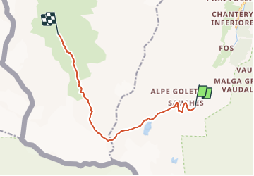
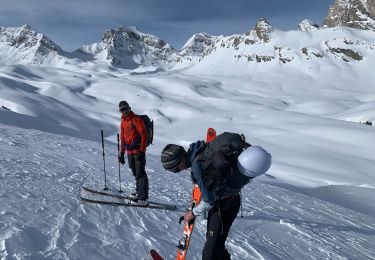
Trail Walking of 10.2 km to be discovered at Aosta Valley, Unknown, Rhêmes-Notre-Dame. This trail is proposed by saphile.

Description

Grand Paradis 2018 - J3

Elevation profile

Points of interest

Point of interest Rhêmes-Notre-Dame - Col Bassac Deré (3083m) - Photo
saphile
RHÊMES-NOTRE-DAME 
Point of interest Valgrisenche - beca - Photo
saphile
VALGRISENCHE 
Point of interest Valgrisenche - grande rousse - Photo
saphile
VALGRISENCHE 
Point of interest Valgrisenche - Point x - Photo
saphile
VALGRISENCHE 
Point of interest Valgrisenche - repere - Photo
saphile
VALGRISENCHE 
Point of interest Valgrisenche - Lac St Martin - Photo
saphile
VALGRISENCHE 

Positioning

Country:
Italy
Region :
Aosta Valley
Department/Province :
Unknown
Municipality :
Rhêmes-Notre-Dame
Location:
Unknown
Start:(UTM)
350383 ; 5042014 (32T) N.

Trails nearby

Trail On foot Valsavarenche - (SI F01) Rifugio Savoia - Rhêmes-Notre-Dame - Photo
On foot
PRO

On foot

Difficult
Valsavarenche, Aosta Valley, Unknown, Italy
21 km | 35 km-effort
8h 3min
No
Trail On foot Ceresole Reale - 3C, Col Rosset - Photo
On foot
PRO

On foot

Easy
Ceresole Reale, Piemont, Torino, Italy
4.9 km | 6.6 km-effort
1h 29min
No
Trail On foot Rhêmes-Notre-Dame - IT-13D - Photo
On foot
PRO

On foot

Easy
Rhêmes-Notre-Dame, Aosta Valley, Unknown, Italy
5.7 km | 16 km-effort
3h 37min
No
Trail On foot Rhêmes-Notre-Dame - IT-14 - Photo
On foot
PRO

On foot

Easy
Rhêmes-Notre-Dame, Aosta Valley, Unknown, Italy
4.7 km | 13.1 km-effort
2h 59min
No
Trail On foot Rhêmes-Notre-Dame - IT-13 - Photo
On foot
PRO

On foot

Easy
Rhêmes-Notre-Dame, Aosta Valley, Unknown, Italy
4.3 km | 8.8 km-effort
2h 0min
No
Trail Walking Rhêmes-Notre-Dame - Rehm rifugio benevolo extension vers lac goletta  - Photo
Walking
romoirand

Walking

Medium
Rhêmes-Notre-Dame, Aosta Valley, Unknown, Italy
8.8 km | 14.7 km-effort
3h 29min
Yes
Trail On foot Rhêmes-Notre-Dame - IT-12 - Photo
On foot
PRO

On foot

Easy
Rhêmes-Notre-Dame, Aosta Valley, Unknown, Italy
5.4 km | 14.1 km-effort
3h 11min
No
Trail Walking Rhêmes-Notre-Dame - traceGP 2024 - J4 - Bénévolo - Bezzi - Photo
Walking
GAPIAN43

Walking

Difficult
Rhêmes-Notre-Dame, Aosta Valley, Unknown, Italy
10.1 km | 21 km-effort
4h 47min
No
Trail Touring skiing Rhêmes-Notre-Dame - Benevolo au pont - Photo
Touring skiing
fpitance

Touring skiing

Rhêmes-Notre-Dame, Aosta Valley, Unknown, Italy
23 km | 36 km-effort
9h 47min
No


Close
My subscriptions