Trail Walking Saint-Paul-sur-Ubaye - Ma Grande Traversée des Alpes en 2017 (GTA) - Photo
© OpenStreetMap contributors
Length
Length
71 km
Max alt
Max alt
2942 m
Uphill gradient
Uphill gradient
4486 m
Km-Effort
Km-Effort  
135 km
Min alt
Min alt
1143 m
Downhill gradient
Downhill gradient
5708 m
Boucle
Boucle
No
Creation date :
2018-04-17 13:39:08.32
Updated on :
2018-04-17 13:39:08.32

(0 Reviews)

Walking
Walking
25h08
Difficulty : Difficult

Scan this QR Code to open this trail in the SityTrail application

FREE GPS app for hiking

Logo SityTrail SityTrail

IGN / Geographical institutes

Download SityTrail from the App Store Download SityTrail from Google Play

Logo SityTrail SityTrail World

The world is yours!

Download SityTrail from the App Store Download SityTrail from Google Play Download SityTrail on Huawei AppGallery

About

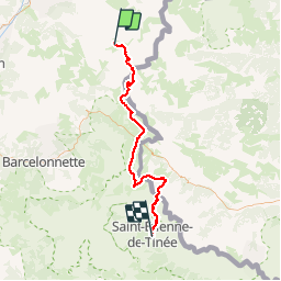
Trail Walking of 71 km to be discovered at Provence-Alpes-Côte d'Azur, Alpes-de-Haute-Provence, Saint-Paul-sur-Ubaye. This trail is proposed by glucorticoide.

Description

Variante Perso GR5 Lac des Vens

https://youtu.be/BzwqsNc-9Vw

Elevation profile

Positioning

Country:
France
Region :
Provence-Alpes-Côte d'Azur
Department/Province :
Alpes-de-Haute-Provence
Municipality :
Saint-Paul-sur-Ubaye
Location:
Unknown
Start:(Dec)
Start:(UTM)
327869 ; 4940637 (32T) N.

Trails nearby

Trail Walking Saint-Paul-sur-Ubaye - 05 Tour Font Sancte - étape 3 - Photo
Walking
Maryma

Walking

Very difficult
(1)
Saint-Paul-sur-Ubaye, Provence-Alpes-Côte d'Azur, Alpes-de-Haute-Provence, France
16.7 km | 31 km-effort
7h 8min
No
Trail Other activity Ceillac - Col de la petite Par. Col Girardin  - Photo
Other activity
GUIDE
nadd73

Other activity

Difficult
Ceillac, Provence-Alpes-Côte d'Azur, Hautes-Alpes, France
13.9 km | 32 km-effort
7h 36min
Yes
Trail Walking Saint-Paul-sur-Ubaye - Pic Panestrel - Photo
Walking
GAPIAN43

Walking

Difficult
(1)
Saint-Paul-sur-Ubaye, Provence-Alpes-Côte d'Azur, Alpes-de-Haute-Provence, France
13 km | 32 km-effort
6h 16min
Yes
Trail Walking Ceillac - Lac Ste Anne et Tête de Girardin - Photo
Walking
GUIDE
amiral13

Walking

Medium
Ceillac, Provence-Alpes-Côte d'Azur, Hautes-Alpes, France
14.4 km | 27 km-effort
5h 48min
Yes
Trail Walking Ceillac - lac Sainte Anne - Photo
Walking
griffet

Walking

Easy
(2)
Ceillac, Provence-Alpes-Côte d'Azur, Hautes-Alpes, France
10.7 km | 17.9 km-effort
5h 16min
No
Trail Walking Ceillac - cols Tronchet et Girardin  - Photo
Walking
GUIDE
orsel

Walking

Medium
Ceillac, Provence-Alpes-Côte d'Azur, Hautes-Alpes, France
13.8 km | 27 km-effort
7h 56min
Yes
Trail Snowshoes Ceillac - ceillac ste Anne lac mirroir 11kms 486m - Photo
Snowshoes
GUIDE
Danielba

Snowshoes

Medium
Ceillac, Provence-Alpes-Côte d'Azur, Hautes-Alpes, France
9.7 km | 16.5 km-effort
6h 57min
No
Trail Walking Saint-Paul-sur-Ubaye - Bric de RUBREN - Photo
Walking
tchoua

Walking

Very difficult
Saint-Paul-sur-Ubaye, Provence-Alpes-Côte d'Azur, Alpes-de-Haute-Provence, France
22 km | 40 km-effort
5h 53min
No
Trail Walking Saint-Paul-sur-Ubaye - Col des Houerts  - Photo
Walking
GUIDE
orsel

Walking

Medium
Saint-Paul-sur-Ubaye, Provence-Alpes-Côte d'Azur, Alpes-de-Haute-Provence, France
14.1 km | 32 km-effort
6h 36min
Yes


Close
My subscriptions