Trail Walking L'Haÿ-les-Roses - 92-PR5 Sentier des bois - Photo
 lasvergn
lasvergn

User

© OpenStreetMap contributors
Length
Length
32 km
Max alt
Max alt
187 m
Uphill gradient
Uphill gradient
724 m
Km-Effort
Km-Effort  
42 km
Min alt
Min alt
45 m
Downhill gradient
Downhill gradient
628 m
Boucle
Boucle
No
Creation date :
2018-04-17 13:37:31.526
Updated on :
2018-04-17 13:37:31.526

(0 Reviews)

Walking
Walking
8h45
Difficulty : Medium

Scan this QR Code to open this trail in the SityTrail application

FREE GPS app for hiking

Logo SityTrail SityTrail

IGN / Geographical institutes

Download SityTrail from the App Store Download SityTrail from Google Play

Logo SityTrail SityTrail World

The world is yours!

Download SityTrail from the App Store Download SityTrail from Google Play Download SityTrail on Huawei AppGallery

About

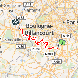
Trail Walking of 32 km to be discovered at Ile-de-France, Val-de-Marne, L'Haÿ-les-Roses. This trail is proposed by lasvergn.

Description

Le sentier traverse les plus grands massifs forestiers des Hauts-de-Seine (92). Il commence dans la vallée de la Bièvres, traverse Bourg la reine, le Plessis-Robinson, Fontenay-aux-roses, rentre dans la forêt de Meudon par le bois de Clamart. Il ressort de la forêt par Chaville, qu'il traverse et pénètre dans la forêt de Fausses Reposes. Il se termine à la gare de Vaucresson.

Elevation profile

Positioning

Country:
France
Region :
Ile-de-France
Department/Province :
Val-de-Marne
Municipality :
L'Haÿ-les-Roses
Location:
Unknown
Start:(UTM)
450359 ; 5402804 (31U) N.

Trails nearby

Trail Walking Sceaux - Les Hauts de Bièvre - Photo
Walking
tracegps

Walking

Difficult
(2)
Sceaux, Ile-de-France, Hauts-de-Seine, France
25 km | 30 km-effort
6h 0min
Yes
Trail Walking Fontenay-aux-Roses -  Rando des 3 Parcs ! (des Gares RER) - Photo
Walking
dmj41

Walking

Very difficult
(2)
Fontenay-aux-Roses, Ile-de-France, Hauts-de-Seine, France
15.9 km | 19.5 km-effort
4h 26min
No
Trail On foot Antony - Sur la Rive Gauche de la Bièvre - Photo
On foot
PRO

On foot

Easy
Antony, Ile-de-France, Hauts-de-Seine, France
5 km | 6.2 km-effort
1h 24min
No
Trail Walking Antony - De gare à gare - Photo
Walking
micheldelaramdo

Walking

Easy
(1)
Antony, Ile-de-France, Hauts-de-Seine, France
6.4 km | 7.2 km-effort
1h 29min
No
Trail Walking Gentilly - BAGNEUX _ GENTILLY 5 KM - Photo
Walking
gemau77

Walking

Medium
(1)
Gentilly, Ile-de-France, Val-de-Marne, France
5.3 km | 6.2 km-effort
1h 23min
No
Trail Walking Sceaux - Sur les pas de Châteaubriant  - Photo
Walking
c.chehere

Walking

Medium
Sceaux, Ile-de-France, Hauts-de-Seine, France
16.7 km | 20 km-effort
4h 33min
Yes
Trail Walking Bagneux - Chatillon - Photo
Walking
c.chehere

Walking

Easy
Bagneux, Ile-de-France, Hauts-de-Seine, France
13.7 km | 16 km-effort
3h 31min
Yes
Trail Walking Verrières-le-Buisson - Bois de Verrières - Parc de Sceaux - Vallée aux Loups de Chatenay - Photo
Walking
Martial LHUILLERY

Walking

Very difficult
Verrières-le-Buisson, Ile-de-France, Essonne, France
19.8 km | 24 km-effort
5h 20min
Yes
Trail Walking Gentilly - MONTSOURIS  A DENFERT ROCHEREAU - Photo
Walking
gemau77

Walking

Medium
(1)
Gentilly, Ile-de-France, Val-de-Marne, France
7.1 km | 8.4 km-effort
1h 54min
No


Close
My subscriptions