92-PR9 Sentier des buttes
lasvergn
User
Length
43 km
Max alt
186 m
Uphill gradient
613 m
Km-Effort
51 km
Min alt
22 m
Downhill gradient
659 m
Boucle
No
Creation date :
2018-04-17 13:36:05.525
Updated on :
2018-04-17 13:36:05.525
10h47
Difficulty : Medium
FREE GPS app for hiking
About
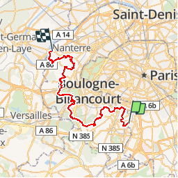
Trail Walking of 43 km to be discovered at Ile-de-France, Val-de-Marne, Cachan. This trail is proposed by lasvergn.
Description
Le sentier des buttes traverse les communes de Bagneux, Montrouge, Malakoff, Châtillon, Clamart, Meudon, Sèvres, le parc de St cloud, Saint Cloud, Garches, Rueil-Malmaison, Suresnes et se termine à la gare RER de Rueil-Malmaison.
Positioning
Country:
France
Region :
Ile-de-France
Department/Province :
Val-de-Marne
Municipality :
Cachan
Location:
Unknown
Start:(Dec)
Start:(UTM)
450123 ; 5404706 (31U) N.
Comments
Trails nearby
DP75-16 De Chevaleret à Tolbiac
Walking
Easy
(1)
Paris,
Ile-de-France,
Paris,
France
4.3 km | 5.1 km-effort
1h 8min
No
Balade Paris Mars - Street art 13 ème / Tours Novel / Mouffetard---> Montorgueil
Walking
Very easy
(1)
Paris,
Ile-de-France,
Paris,
France
18.4 km | 22 km-effort
6h 21min
No
Les Hauts de Bièvre
Walking
Difficult
(2)
Sceaux,
Ile-de-France,
Hauts-de-Seine,
France
25 km | 30 km-effort
6h 0min
Yes
Rando des 3 Parcs ! (des Gares RER)
Walking
Very difficult
(2)
Fontenay-aux-Roses,
Ile-de-France,
Hauts-de-Seine,
France
15.9 km | 19.5 km-effort
4h 26min
No
Sur la Rive Gauche de la Bièvre
On foot
Easy
Antony,
Ile-de-France,
Hauts-de-Seine,
France
5 km | 6.2 km-effort
1h 24min
No
De gare à gare
Walking
Easy
(1)
Antony,
Ile-de-France,
Hauts-de-Seine,
France
6.4 km | 7.2 km-effort
1h 29min
No
Coulée verte - Paris
Walking
Easy
(1)
Paris,
Ile-de-France,
Paris,
France
12 km | 14.2 km-effort
2h 0min
Yes
porte de Versailles Notre Dame
Walking
Easy
Paris,
Ile-de-France,
Paris,
France
10.7 km | 13 km-effort
2h 39min
No
BAGNEUX _ GENTILLY 5 KM
Walking
Medium
(1)
Gentilly,
Ile-de-France,
Val-de-Marne,
France
5.3 km | 6.2 km-effort
1h 23min
No