![](/images/other/stat-length.png)
![Trail Nordic walking Fréjus - MN cool Rte de Malpasset Boson - Photo](https://media.geolcdn.com/t/1900/400/ext.pjpeg?maxdim=2&url=https%3A%2F%2Fstatic1.geolcdn.com%2Fsiteimages%2Fupload%2Ffiles%2F1545311037marcheuse_200dpi.jpg)
MN cool Rte de Malpasset Boson
Domi1953
User
![Length](/images/other/stat-length.png)
Length
5.1 km
![Max alt](https://static1.geolcdn.com/siteimages/upload/files/1508320355ic_sort_altitude_max_24dp.png)
Max alt
89 m
![Uphill gradient](https://static1.geolcdn.com/siteimages/upload/files/1508320355ic_sort_den_pos_24dp.png)
Uphill gradient
120 m
![Km-Effort](/images/other/stat-length.png)
Km-Effort
6.6 km
![Min alt](https://static1.geolcdn.com/siteimages/upload/files/1508320355ic_sort_altitude_min_24dp.png)
Min alt
35 m
![Downhill gradient](https://static1.geolcdn.com/siteimages/upload/files/1508320355ic_sort_den_neg_24dp.png)
Downhill gradient
81 m
![Boucle](https://static1.geolcdn.com/siteimages/upload/files/16400158638029165_repeat_loop_refresh_sync_direction_icon.png)
Boucle
No
Creation date :
2019-01-09 17:57:24.619
Updated on :
2019-01-09 17:57:24.653
![Nordic walking](https://static1.geolcdn.com/sitytour/trail-icons/102.png)
2h00
Difficulty : Easy
![Scan this QR Code to open this trail in the SityTrail application](https://capi.geolives.com/qq0zvz2zws4bq2lad0pu/sitytour/trails/867586/qr.png?size=200)
FREE GPS app for hiking
About
Trail Nordic walking of 5.1 km to be discovered at Provence-Alpes-Côte d'Azur, Var, Fréjus. This trail is proposed by Domi1953.
Description
Dpart D37 - Piste d'Auriasque - A G piste de Boson - Jusqu'à X avec GR 51 Esquine - A G - GR51 Esquine jusqu'à pont de l'A8 - à Dr vers piste d'Ambon - retour X D37/ Piste d'Auriasque
Positioning
Country:
France
Region :
Provence-Alpes-Côte d'Azur
Department/Province :
Var
Municipality :
Fréjus
Location:
Unknown
Start:(Dec)
Start:(UTM)
318753 ; 4818649 (32T) N.
Comments
Trails nearby
![Walking Walking](https://static1.geolcdn.com/sitytour/trail-icons/101.png)
Lac de l'Avelan au départ du col d'Auriasque
Walking
Easy
(2)
Fréjus,
Provence-Alpes-Côte d'Azur,
Var,
France
![](/images/other/stat-length.png)
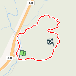
16.6 km | 23 km-effort
5h 39min
![](https://static1.geolcdn.com/siteimages/upload/files/16400158638029165_repeat_loop_refresh_sync_direction_icon.png)
Yes
![Trail Walking Fréjus - z l'Estarpe 13-11-18 - Photo](https://media.geolcdn.com/t/375/260/aa64f113-051e-42b9-996b-5410a2d62b76.jpg&format=jpg&maxdim=2)
![Walking Walking](https://static1.geolcdn.com/sitytour/trail-icons/101.png)
z l'Estarpe 13-11-18
Walking
Easy
(1)
Fréjus,
Provence-Alpes-Côte d'Azur,
Var,
France
![](/images/other/stat-length.png)
6.6 km | 8.2 km-effort
1h 51min
![](https://static1.geolcdn.com/siteimages/upload/files/16400158638029165_repeat_loop_refresh_sync_direction_icon.png)
Yes
![Trail Walking Fréjus - Plan d'Esterel - mont Vinaigre - tour des Malavalettes - Photo](https://media.geolcdn.com/t/375/260/ext.jpg?maxdim=2&url=https%3A%2F%2Fservices.sitytrail.com%2FGeolivesWS%2FDownloadMedia.ashx%3FTrailID%3D957209%26Media%3Dfix__20180503165001.jpg)
![Walking Walking](https://static1.geolcdn.com/sitytour/trail-icons/101.png)
Plan d'Esterel - mont Vinaigre - tour des Malavalettes
Walking
Medium
(1)
Fréjus,
Provence-Alpes-Côte d'Azur,
Var,
France
![](/images/other/stat-length.png)
15.4 km | 22 km-effort
5h 22min
![](https://static1.geolcdn.com/siteimages/upload/files/16400158638029165_repeat_loop_refresh_sync_direction_icon.png)
Yes
![Trail Mountain bike Fréjus - grand tour esterel par belles pistes larges - Photo](https://media.geolcdn.com/t/375/260/ext.jpg?maxdim=2&url=https%3A%2F%2Fservices.sitytrail.com%2FGeolivesWS%2FDownloadMedia.ashx%3FTrailID%3D251652%26Media%3Dfix__20140216105744.jpg)
![Mountain bike Mountain bike](https://static1.geolcdn.com/sitytour/trail-icons/202.png)
grand tour esterel par belles pistes larges
Mountain bike
Easy
(2)
Fréjus,
Provence-Alpes-Côte d'Azur,
Var,
France
![](/images/other/stat-length.png)
31 km | 40 km-effort
3h 17min
![](https://static1.geolcdn.com/siteimages/upload/files/16400158638029165_repeat_loop_refresh_sync_direction_icon.png)
Yes
![Trail Mountain bike Puget-sur-Argens - Forêt de la Colle du Rouet aux Gorges de Blavet - Fréjus - Photo](https://media.geolcdn.com/t/375/260/ext.jpg?maxdim=2&url=https%3A%2F%2Fservices.sitytrail.com%2FGeolivesWS%2FDownloadMedia.ashx%3FTrailID%3D191635%26Media%3D15278_6.jpg)
![Mountain bike Mountain bike](https://static1.geolcdn.com/sitytour/trail-icons/202.png)
Forêt de la Colle du Rouet aux Gorges de Blavet - Fréjus
Mountain bike
Difficult
(1)
Puget-sur-Argens,
Provence-Alpes-Côte d'Azur,
Var,
France
![](/images/other/stat-length.png)
23 km | 28 km-effort
3h 0min
![](https://static1.geolcdn.com/siteimages/upload/files/16400158638029165_repeat_loop_refresh_sync_direction_icon.png)
Yes
![Trail Walking Fréjus - Mont Vinaigre par Colle Douce - Photo](https://media.geolcdn.com/t/375/260/e50e9530-bac2-442d-a80a-5b2b78c05c8e.jpg&format=jpg&maxdim=2)
![Walking Walking](https://static1.geolcdn.com/sitytour/trail-icons/101.png)
Mont Vinaigre par Colle Douce
Walking
Very difficult
(1)
Fréjus,
Provence-Alpes-Côte d'Azur,
Var,
France
![](/images/other/stat-length.png)
22 km | 33 km-effort
6h 1min
![](https://static1.geolcdn.com/siteimages/upload/files/16400158638029165_repeat_loop_refresh_sync_direction_icon.png)
Yes
![Trail Walking Fréjus - barage du malpasser - Photo](https://media.geolcdn.com/t/375/260/ext.jpg?maxdim=2&url=https%3A%2F%2Fservices.sitytrail.com%2FGeolivesWS%2FDownloadMedia.ashx%3FTrailID%3D232087%26Media%3Dfix__20131111135300.jpg)
![Walking Walking](https://static1.geolcdn.com/sitytour/trail-icons/101.png)
barage du malpasser
Walking
Very easy
(1)
Fréjus,
Provence-Alpes-Côte d'Azur,
Var,
France
![](/images/other/stat-length.png)
5.1 km | 7.6 km-effort
1h 55min
![](https://static1.geolcdn.com/siteimages/upload/files/16400158638029165_repeat_loop_refresh_sync_direction_icon.png)
Yes
![Trail Walking Fréjus - Plan d'Estérel - Mont Vinaigre - Photo](https://media.geolcdn.com/t/375/260/ext.jpg?maxdim=2&url=https%3A%2F%2Fservices.sitytrail.com%2FGeolivesWS%2FDownloadMedia.ashx%3FTrailID%3D105012%26Media%3D8573_2.jpg)
![Walking Walking](https://static1.geolcdn.com/sitytour/trail-icons/101.png)
Plan d'Estérel - Mont Vinaigre
Walking
Medium
(1)
Fréjus,
Provence-Alpes-Côte d'Azur,
Var,
France
![](/images/other/stat-length.png)
15.6 km | 22 km-effort
4h 0min
![](https://static1.geolcdn.com/siteimages/upload/files/16400158638029165_repeat_loop_refresh_sync_direction_icon.png)
Yes
![Trail Walking Fréjus - Mont Vinaigre - Photo](https://media.geolcdn.com/t/375/260/ext.jpg?maxdim=2&url=https%3A%2F%2Fservices.sitytrail.com%2FGeolivesWS%2FDownloadMedia.ashx%3FTrailID%3D72603%26Media%3D20110718145720.jpeg)
![Walking Walking](https://static1.geolcdn.com/sitytour/trail-icons/101.png)
Mont Vinaigre
Walking
Easy
(1)
Fréjus,
Provence-Alpes-Côte d'Azur,
Var,
France
![](/images/other/stat-length.png)
7.8 km | 11.9 km-effort
Unknown
![](https://static1.geolcdn.com/siteimages/upload/files/16400158638029165_repeat_loop_refresh_sync_direction_icon.png)
Yes