![](/images/other/stat-length.png)
![Trail Walking Le Sappey-en-Chartreuse - La Habert de Chamechaude en boucle par les Emeindras - Photo](https://media.geolcdn.com/t/1900/400/ext.pjpeg?maxdim=2&url=https%3A%2F%2Fservices.sitytrail.com%2FGeolivesWS%2FDownloadMedia.ashx%3FTrailID%3D866462%26Media%3Dfix__20171123125904.jpg)
La Habert de Chamechaude en boucle par les Emeindras
patjobou
User
![Length](/images/other/stat-length.png)
Length
11.7 km
![Max alt](https://static1.geolcdn.com/siteimages/upload/files/1508320355ic_sort_altitude_max_24dp.png)
Max alt
1604 m
![Uphill gradient](https://static1.geolcdn.com/siteimages/upload/files/1508320355ic_sort_den_pos_24dp.png)
Uphill gradient
717 m
![Km-Effort](/images/other/stat-length.png)
Km-Effort
21 km
![Min alt](https://static1.geolcdn.com/siteimages/upload/files/1508320355ic_sort_altitude_min_24dp.png)
Min alt
1003 m
![Downhill gradient](https://static1.geolcdn.com/siteimages/upload/files/1508320355ic_sort_den_neg_24dp.png)
Downhill gradient
717 m
![Boucle](https://static1.geolcdn.com/siteimages/upload/files/16400158638029165_repeat_loop_refresh_sync_direction_icon.png)
Boucle
Yes
Creation date :
2018-04-17 13:20:18.088
Updated on :
2018-04-17 13:20:18.088
![Walking](https://static1.geolcdn.com/sitytour/trail-icons/101.png)
4h21
Difficulty : Medium
![Scan this QR Code to open this trail in the SityTrail application](https://capi.geolives.com/qq0zvz2zws4bq2lad0pu/sitytour/trails/866462/qr.png?size=200)
FREE GPS app for hiking
About
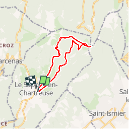
Trail Walking of 11.7 km to be discovered at Auvergne-Rhône-Alpes, Isère, Le Sappey-en-Chartreuse. This trail is proposed by patjobou.
Description
Belle boucle avec un peu de neige au sol. 1h30 de montée jusqu'au habert, 1h pour traverser jusqu'à l'Emeindras du dessus, 4h30 en tout.
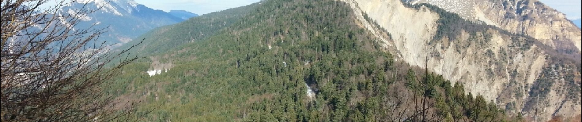
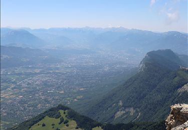
Du sommet, vers le NO, on accède à un beau belvédère sur la Dent de Crolles.
Positioning
Country:
France
Region :
Auvergne-Rhône-Alpes
Department/Province :
Isère
Municipality :
Le Sappey-en-Chartreuse
Location:
Unknown
Start:(Dec)
Start:(UTM)
718024 ; 5015413 (31T) N.
Comments
Trails nearby
![Trail Walking Saint-Nazaire-les-Eymes - Chateau-Nardent par le C9 - Photo](https://media.geolcdn.com/t/375/260/536a5eba-5214-4ffc-98c0-901c667d171a.jpg&format=jpg&maxdim=2)
![Walking Walking](https://static1.geolcdn.com/sitytour/trail-icons/101.png)
Chateau-Nardent par le C9
Walking
Difficult
(2)
Saint-Nazaire-les-Eymes,
Auvergne-Rhône-Alpes,
Isère,
France
![](/images/other/stat-length.png)
8.2 km | 17.7 km-effort
6h 23min
![](https://static1.geolcdn.com/siteimages/upload/files/16400158638029165_repeat_loop_refresh_sync_direction_icon.png)
Yes
![Trail Walking Corenc - Mont Saint-Eynard par le Pas Guiguet - Photo](https://media.geolcdn.com/t/375/260/f1d9b7f1-9f84-43fa-9ff3-d6f6d9ae7425.jpg&format=jpg&maxdim=2)
![Walking Walking](https://static1.geolcdn.com/sitytour/trail-icons/101.png)
Mont Saint-Eynard par le Pas Guiguet
Walking
Difficult
(2)
Corenc,
Auvergne-Rhône-Alpes,
Isère,
France
![](/images/other/stat-length.png)
10.9 km | 26 km-effort
6h 5min
![](https://static1.geolcdn.com/siteimages/upload/files/16400158638029165_repeat_loop_refresh_sync_direction_icon.png)
Yes
![Trail Walking Sarcenas - Chamechaude par le Jardin, depuis le Col de Porte - Photo](https://media.geolcdn.com/t/375/260/ext.jpg?maxdim=2&url=https%3A%2F%2Fservices.sitytrail.com%2FGeolivesWS%2FDownloadMedia.ashx%3FTrailID%3D101654%26Media%3D1865_1.jpg)
![Walking Walking](https://static1.geolcdn.com/sitytour/trail-icons/101.png)
Chamechaude par le Jardin, depuis le Col de Porte
Walking
Difficult
(2)
Sarcenas,
Auvergne-Rhône-Alpes,
Isère,
France
![](/images/other/stat-length.png)
10 km | 23 km-effort
6h 19min
![](https://static1.geolcdn.com/siteimages/upload/files/16400158638029165_repeat_loop_refresh_sync_direction_icon.png)
Yes
![Trail On foot Plateau-des-Petites-Roches - Tour de Pravouta - Photo](https://media.geolcdn.com/t/375/260/432c9697-22d9-4837-a6d3-2165ebce375b.jpeg&format=jpg&maxdim=2)
![On foot On foot](https://static1.geolcdn.com/sitytour/trail-icons/100.png)
Tour de Pravouta
On foot
Easy
Plateau-des-Petites-Roches,
Auvergne-Rhône-Alpes,
Isère,
France
![](/images/other/stat-length.png)
3.9 km | 7.5 km-effort
1h 42min
![](https://static1.geolcdn.com/siteimages/upload/files/16400158638029165_repeat_loop_refresh_sync_direction_icon.png)
Yes
![Trail Walking Plateau-des-Petites-Roches - Dent de Crolles - Photo](https://media.geolcdn.com/t/375/260/ext.jpg?maxdim=2&url=https%3A%2F%2Fservices.sitytrail.com%2FGeolivesWS%2FDownloadMedia.ashx%3FTrailID%3D187983%26Media%3D31eff9e1-5e80-41ea-8f5f-6c9fa39600c7.JPG)
![Walking Walking](https://static1.geolcdn.com/sitytour/trail-icons/101.png)
Dent de Crolles
Walking
Difficult
(1)
Plateau-des-Petites-Roches,
Auvergne-Rhône-Alpes,
Isère,
France
![](/images/other/stat-length.png)
8.4 km | 18 km-effort
3h 40min
![](https://static1.geolcdn.com/siteimages/upload/files/16400158638029165_repeat_loop_refresh_sync_direction_icon.png)
Yes
![Trail Touring skiing Sarcenas - 151224 Vers Chamechaude - Photo](https://media.geolcdn.com/t/375/260/82fefdbb-30e3-407c-be50-449c98f9499e.jpg&format=jpg&maxdim=2)
![Touring skiing Touring skiing](https://static1.geolcdn.com/sitytour/trail-icons/503.png)
151224 Vers Chamechaude
Touring skiing
Very easy
Sarcenas,
Auvergne-Rhône-Alpes,
Isère,
France
![](/images/other/stat-length.png)
6.7 km | 16.7 km-effort
2h 58min
![](https://static1.geolcdn.com/siteimages/upload/files/16400158638029165_repeat_loop_refresh_sync_direction_icon.png)
Yes
![Trail Walking Sarcenas - chamchaude par la brèche Arnaud - Photo](https://media.geolcdn.com/t/375/260/a3a4f254-ac9d-4ad4-a4a6-5e5c59427381.jpg&format=jpg&maxdim=2)
![Walking Walking](https://static1.geolcdn.com/sitytour/trail-icons/101.png)
chamchaude par la brèche Arnaud
Walking
Very difficult
Sarcenas,
Auvergne-Rhône-Alpes,
Isère,
France
![](/images/other/stat-length.png)
9.7 km | 20 km-effort
2h 48min
![](https://static1.geolcdn.com/siteimages/upload/files/16400158638029165_repeat_loop_refresh_sync_direction_icon.png)
Yes
![Trail Mountain bike Proveysieux - Panflay- Plaine de Girieux- Col de la charmette - Photo](https://media.geolcdn.com/t/375/260/324a1437-8510-48a9-87cc-97834ce29b12.jpg&format=jpg&maxdim=2)
![Mountain bike Mountain bike](https://static1.geolcdn.com/sitytour/trail-icons/202.png)
Panflay- Plaine de Girieux- Col de la charmette
Mountain bike
Difficult
Proveysieux,
Auvergne-Rhône-Alpes,
Isère,
France
![](/images/other/stat-length.png)
15.6 km | 24 km-effort
2h 17min
![](https://static1.geolcdn.com/siteimages/upload/files/16400158638029165_repeat_loop_refresh_sync_direction_icon.png)
Yes
![Trail Walking Sarcenas - la Pinéa du col de Portes - Photo](https://media.geolcdn.com/t/375/260/3f1da119-342b-40ef-b4a5-52520786c4f5.jpg&format=jpg&maxdim=2)
![Walking Walking](https://static1.geolcdn.com/sitytour/trail-icons/101.png)
la Pinéa du col de Portes
Walking
Difficult
Sarcenas,
Auvergne-Rhône-Alpes,
Isère,
France
![](/images/other/stat-length.png)
8.7 km | 14.4 km-effort
4h 41min
![](https://static1.geolcdn.com/siteimages/upload/files/16400158638029165_repeat_loop_refresh_sync_direction_icon.png)
Yes