![](/images/other/stat-length.png)
![Trail Walking Monschau - 2018-ES-GR15-Monschau-Barrage_Vesdre-18,6km - Photo](https://media.geolcdn.com/t/1900/400/ext.pjpeg?maxdim=2&url=https%3A%2F%2Fstatic1.geolcdn.com%2Fsiteimages%2Fupload%2Ffiles%2F1553511878bg_sport_marche.png)
2018-ES-GR15-Monschau-Barrage_Vesdre-18,6km
yamadix
User
![Length](/images/other/stat-length.png)
Length
18.5 km
![Max alt](https://static1.geolcdn.com/siteimages/upload/files/1508320355ic_sort_altitude_max_24dp.png)
Max alt
669 m
![Uphill gradient](https://static1.geolcdn.com/siteimages/upload/files/1508320355ic_sort_den_pos_24dp.png)
Uphill gradient
330 m
![Km-Effort](/images/other/stat-length.png)
Km-Effort
23 km
![Min alt](https://static1.geolcdn.com/siteimages/upload/files/1508320355ic_sort_altitude_min_24dp.png)
Min alt
300 m
![Downhill gradient](https://static1.geolcdn.com/siteimages/upload/files/1508320355ic_sort_den_neg_24dp.png)
Downhill gradient
435 m
![Boucle](https://static1.geolcdn.com/siteimages/upload/files/16400158638029165_repeat_loop_refresh_sync_direction_icon.png)
Boucle
No
Creation date :
2018-04-17 12:44:59.942
Updated on :
2018-04-17 12:44:59.942
![Walking](https://static1.geolcdn.com/sitytour/trail-icons/101.png)
5h01
Difficulty : Easy
![Scan this QR Code to open this trail in the SityTrail application](https://capi.geolives.com/qq0zvz2zws4bq2lad0pu/sitytour/trails/861445/qr.png?size=200)
FREE GPS app for hiking
About
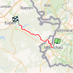
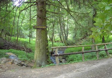
Trail Walking of 18.5 km to be discovered at North Rhine-Westphalia, Städteregion Aachen, Monschau. This trail is proposed by yamadix.
Description
Départ : Hôtel Royal - Stadtstrasse 4-6 - 52156 Monschau
Arrivée : Café-Pension Zum Goldenen Anker - Marktplatz 13 - 4700 Eupen
Positioning
Country:
Germany
Region :
North Rhine-Westphalia
Department/Province :
Städteregion Aachen
Municipality :
Monschau
Location:
Unknown
Start:(Dec)
Start:(UTM)
304581 ; 5603898 (32U) N.
Comments
Trails nearby
![Trail Walking Monschau - 2024-03-28_17h00m40_partnerweg-des-eifelsteigs-narzissenroute (1) - Photo](https://media.geolcdn.com/t/375/260/f78b6422-c27b-477b-b695-82eecbd61b40.jpg&format=jpg&maxdim=2)
![Walking Walking](https://static1.geolcdn.com/sitytour/trail-icons/101.png)
2024-03-28_17h00m40_partnerweg-des-eifelsteigs-narzissenroute (1)
Walking
Medium
(1)
Monschau,
North Rhine-Westphalia,
Städteregion Aachen,
Germany
![](/images/other/stat-length.png)
14.8 km | 18.2 km-effort
4h 8min
![](https://static1.geolcdn.com/siteimages/upload/files/16400158638029165_repeat_loop_refresh_sync_direction_icon.png)
Yes
![Trail Walking Monschau - Montjoie - Ternell en ligne - Photo](https://media.geolcdn.com/t/375/260/d0229e76-e80b-4ee0-af20-8e96d215cea3.jpg&format=jpg&maxdim=2)
![Walking Walking](https://static1.geolcdn.com/sitytour/trail-icons/101.png)
Montjoie - Ternell en ligne
Walking
Medium
(1)
Monschau,
North Rhine-Westphalia,
Städteregion Aachen,
Germany
![](/images/other/stat-length.png)
13.2 km | 17.1 km-effort
3h 52min
![](https://static1.geolcdn.com/siteimages/upload/files/16400158638029165_repeat_loop_refresh_sync_direction_icon.png)
No
![Trail Walking Bütgenbach - 2021-08-07_23h49m19_kalterherberg - Photo](https://media.geolcdn.com/t/375/260/f30f3eaf-c1e4-41d4-bcfb-42e5cbece161.jpg&format=jpg&maxdim=2)
![Walking Walking](https://static1.geolcdn.com/sitytour/trail-icons/101.png)
2021-08-07_23h49m19_kalterherberg
Walking
Easy
(3)
Bütgenbach,
Wallonia,
Liège,
Belgium
![](/images/other/stat-length.png)
13.8 km | 17.3 km-effort
3h 56min
![](https://static1.geolcdn.com/siteimages/upload/files/16400158638029165_repeat_loop_refresh_sync_direction_icon.png)
Yes
![Trail Walking Monschau - rando kalterherberg-rocher bieley 11/08/2021 - Photo](https://media.geolcdn.com/t/375/260/b8400c0e-5378-474d-9c63-b53205ca548b.jpg&format=jpg&maxdim=2)
![Walking Walking](https://static1.geolcdn.com/sitytour/trail-icons/101.png)
rando kalterherberg-rocher bieley 11/08/2021
Walking
Medium
(1)
Monschau,
North Rhine-Westphalia,
Städteregion Aachen,
Germany
![](/images/other/stat-length.png)
18.3 km | 23 km-effort
4h 11min
![](https://static1.geolcdn.com/siteimages/upload/files/16400158638029165_repeat_loop_refresh_sync_direction_icon.png)
No
![Trail Walking Eupen - Hautes Fagnes hohes Venn 20 km - Photo](https://media.geolcdn.com/t/375/260/6f1cadd0-76cd-4012-82b6-befbf33ff4a3.jpg&format=jpg&maxdim=2)
![Walking Walking](https://static1.geolcdn.com/sitytour/trail-icons/101.png)
Hautes Fagnes hohes Venn 20 km
Walking
Medium
(1)
Eupen,
Wallonia,
Liège,
Belgium
![](/images/other/stat-length.png)
20 km | 23 km-effort
6h 1min
![](https://static1.geolcdn.com/siteimages/upload/files/16400158638029165_repeat_loop_refresh_sync_direction_icon.png)
Yes
![Trail On foot Monschau - Eifelverein Rohren - Weg 57 - Photo](https://media.geolcdn.com/t/375/260/a620ba14-736e-46ad-b0d4-965dfc1d4df3.jpeg&format=jpg&maxdim=2)
![On foot On foot](https://static1.geolcdn.com/sitytour/trail-icons/100.png)
Eifelverein Rohren - Weg 57
On foot
Medium
(1)
Monschau,
North Rhine-Westphalia,
Städteregion Aachen,
Germany
![](/images/other/stat-length.png)
15.1 km | 20 km-effort
4h 34min
![](https://static1.geolcdn.com/siteimages/upload/files/16400158638029165_repeat_loop_refresh_sync_direction_icon.png)
Yes
![Trail On foot Simmerath - Zur Ölmühle - Photo](https://media.geolcdn.com/t/375/260/acc51ee5-0286-4f84-ba55-5791dee5e476.jpeg&format=jpg&maxdim=2)
![On foot On foot](https://static1.geolcdn.com/sitytour/trail-icons/100.png)
Zur Ölmühle
On foot
Easy
Simmerath,
North Rhine-Westphalia,
Städteregion Aachen,
Germany
![](/images/other/stat-length.png)
10.9 km | 14.3 km-effort
3h 15min
![](https://static1.geolcdn.com/siteimages/upload/files/16400158638029165_repeat_loop_refresh_sync_direction_icon.png)
Yes
![Trail On foot Simmerath - Flurheckenweg Eicherscheid - Photo](https://media.geolcdn.com/t/375/260/4e1bbe09-5ed6-460b-be04-ce40a88226b7.jpeg&format=jpg&maxdim=2)
![On foot On foot](https://static1.geolcdn.com/sitytour/trail-icons/100.png)
Flurheckenweg Eicherscheid
On foot
Easy
Simmerath,
North Rhine-Westphalia,
Städteregion Aachen,
Germany
![](/images/other/stat-length.png)
7.8 km | 9.1 km-effort
2h 3min
![](https://static1.geolcdn.com/siteimages/upload/files/16400158638029165_repeat_loop_refresh_sync_direction_icon.png)
Yes
![Trail On foot Monschau - Monschauer Nationalpark-Wanderweg](https://media.geolcdn.com/t/375/260/6ecae744-a5e1-4d67-8c65-d4bc2433654d.jpeg&format=jpg&maxdim=2)
![On foot On foot](https://static1.geolcdn.com/sitytour/trail-icons/100.png)
Monschauer Nationalpark-Wanderweg "Wasser, Wolle, Schieferstein"
On foot
Easy
Monschau,
North Rhine-Westphalia,
Städteregion Aachen,
Germany
![](/images/other/stat-length.png)
5.9 km | 8.6 km-effort
1h 57min
![](https://static1.geolcdn.com/siteimages/upload/files/16400158638029165_repeat_loop_refresh_sync_direction_icon.png)
No