Trail Walking Heidwiller - 68 Heidwiller - Eglingen - Photo

68 Heidwiller - Eglingen

 E.BURCK
E.BURCK

User

© OpenStreetMap contributors
Length
Length
11.7 km
Max alt
Max alt
364 m
Uphill gradient
Uphill gradient
230 m
Km-Effort
Km-Effort  
14.8 km
Min alt
Min alt
264 m
Downhill gradient
Downhill gradient
231 m
Boucle
Boucle
Yes
Creation date :
2019-05-22 16:12:34.318
Updated on :
2022-12-07 14:35:41.892

(1 Reviews)

Walking
Walking
3h08
Difficulty : Easy

Scan this QR Code to open this trail in the SityTrail application

FREE GPS app for hiking

Logo SityTrail SityTrail

IGN / Geographical institutes

Download SityTrail from the App Store Download SityTrail from Google Play

Logo SityTrail SityTrail World

The world is yours!

Download SityTrail from the App Store Download SityTrail from Google Play Download SityTrail on Huawei AppGallery

About

Trail Walking of 11.7 km to be discovered at Grand Est, Haut-Rhin, Heidwiller. This trail is proposed by E.BURCK.

Description

Une balade facile vers Eglingen, dans le Sundgau. (223 m de dénivelé et 12 km)

ACCÈS :  
- Sur la D18 le long du canal entre Heidwiller et Eglingen(voir plan)
PARKING:
- à droite, environ 100 m après le rond point, en direction de Eglingen.

47.65746 ,             7.2190058   ou        
N 47°39'27"      E  7°13'09"  

RESTAURATION :  
Restaurant à l'Arbre Vert, 18 rue Principale à Eglingen.
Tél.: 03 89 25 30 29

Elevation profile

Positioning

Country:
France
Region :
Grand Est
Department/Province :
Haut-Rhin
Municipality :
Heidwiller
Location:
Unknown
Start:(UTM)
366247 ; 5279752 (32T) N.

Comments

Please log in to post a review or rate the element


Trails nearby

Trail Walking Carspach - Entraînement Trek Tignes septembre 5024 - Photo
Walking
boubou68

Walking

Very difficult
Carspach, Grand Est, Haut-Rhin, France
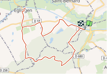
15.1 km | 22 km-effort
3h 2min
Yes
Trail Walking Wittersdorf - rdpr wittersdorf matin 220208 - Photo
Walking
GUIDE
stempfel52

Walking

Medium
Wittersdorf, Grand Est, Haut-Rhin, France
8.8 km | 11.5 km-effort
3h 6min
Yes
Trail Walking Illfurth - Illfurth Luemschwillrr Obermorschwiller - Photo
Walking
selevrich

Walking

Easy
Illfurth, Grand Est, Haut-Rhin, France
28 km | 34 km-effort
3h 28min
No
Trail Walking Carspach - Carspach (21/02/2019) - Photo
Walking
Richard68500

Walking

Easy
Carspach, Grand Est, Haut-Rhin, France
13.2 km | 17.7 km-effort
3h 8min
Yes
Trail Walking Walheim - Walheim-Illfuhrt (1-3-2018) - Photo
Walking
Richard68500

Walking

Easy
Walheim, Grand Est, Haut-Rhin, France
13.6 km | 18.2 km-effort
3h 32min
Yes
Trail Running Walheim - noel - Photo
Running
flip6868

Running

Easy
Walheim, Grand Est, Haut-Rhin, France
5.3 km | 6.8 km-effort
55min
Yes
Trail Running Walheim - noel - Photo
Running
flip6868

Running

Easy
Walheim, Grand Est, Haut-Rhin, France
5.3 km | 6.8 km-effort
55min
Yes
Trail Mountain bike Walheim - 2010-10-31 - 10h56m09 - Photo
Mountain bike
sergeh68

Mountain bike

Very easy
Walheim, Grand Est, Haut-Rhin, France
34 km | 42 km-effort
Unknown
Yes
Trail Walking Carspach - Carspach (13 février 2020) - Photo
Walking
Richard68500

Walking

Easy
Carspach, Grand Est, Haut-Rhin, France
14.1 km | 17 km-effort
3h 36min
Yes


Close
My subscriptions