![](/images/other/stat-length.png)
![Trail Walking Campan - Artigue - lac Arize - col d'Arize - Pic de la Montagnette - Pic de Ballonque - col de Ballonque - Photo](https://media.geolcdn.com/t/1900/400/ext.pjpeg?maxdim=2&url=https%3A%2F%2Fstatic1.geolcdn.com%2Fsiteimages%2Fupload%2Ffiles%2F1553511878bg_sport_marche.png)
Artigue - lac Arize - col d'Arize - Pic de la Montagnette - Pic de Ballonque - col de Ballonque
Prala
User
![Length](/images/other/stat-length.png)
Length
13 km
![Max alt](https://static1.geolcdn.com/siteimages/upload/files/1508320355ic_sort_altitude_max_24dp.png)
Max alt
2269 m
![Uphill gradient](https://static1.geolcdn.com/siteimages/upload/files/1508320355ic_sort_den_pos_24dp.png)
Uphill gradient
1036 m
![Km-Effort](/images/other/stat-length.png)
Km-Effort
27 km
![Min alt](https://static1.geolcdn.com/siteimages/upload/files/1508320355ic_sort_altitude_min_24dp.png)
Min alt
1300 m
![Downhill gradient](https://static1.geolcdn.com/siteimages/upload/files/1508320355ic_sort_den_neg_24dp.png)
Downhill gradient
1035 m
![Boucle](https://static1.geolcdn.com/siteimages/upload/files/16400158638029165_repeat_loop_refresh_sync_direction_icon.png)
Boucle
Yes
Creation date :
2018-04-17 11:08:58.831
Updated on :
2018-04-17 11:08:58.831
![Walking](https://static1.geolcdn.com/sitytour/trail-icons/101.png)
5h27
Difficulty : Medium
![Scan this QR Code to open this trail in the SityTrail application](https://capi.geolives.com/qq0zvz2zws4bq2lad0pu/sitytour/trails/849058/qr.png?size=200)
FREE GPS app for hiking
About
Trail Walking of 13 km to be discovered at Occitania, Hautespyrenees, Campan. This trail is proposed by Prala.
Description
Départ d'Artigue sur la route de la Mongie. Cabanes de Tramazaygues, passage sur la droite du Tuhou du Goulet, Lac d'Arize, col d'Arize, Pic de la Montagnette suivi du Pic de Ballonque.Descente par le col de Ballonque vers le pasage du Tuhiy du Goulet et retour au point de départ.
Positioning
Country:
France
Region :
Occitania
Department/Province :
Hautespyrenees
Municipality :
Campan
Location:
Unknown
Start:(Dec)
Start:(UTM)
271365 ; 4756518 (31T) N.
Comments
Trails nearby
![Trail Walking Campan - Lac d'Arizes - Campan - Photo](https://media.geolcdn.com/t/375/260/ext.jpg?maxdim=2&url=https%3A%2F%2Fservices.sitytrail.com%2FGeolivesWS%2FDownloadMedia.ashx%3FTrailID%3D173079%26Media%3D14618_5.jpg)
![Walking Walking](https://static1.geolcdn.com/sitytour/trail-icons/101.png)
Lac d'Arizes - Campan
Walking
Medium
(1)
Campan,
Occitania,
Hautespyrenees,
France
![](/images/other/stat-length.png)
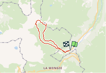
10.2 km | 20 km-effort
3h 30min
![](https://static1.geolcdn.com/siteimages/upload/files/16400158638029165_repeat_loop_refresh_sync_direction_icon.png)
Yes
![Trail Walking Campan - La soula de Tournes - Photo](https://media.geolcdn.com/t/375/260/ext.jpg?maxdim=2&url=https%3A%2F%2Fstatic1.geolcdn.com%2Fsiteimages%2Fupload%2Ffiles%2F1553511878bg_sport_marche.png)
![Walking Walking](https://static1.geolcdn.com/sitytour/trail-icons/101.png)
La soula de Tournes
Walking
Easy
(1)
Campan,
Occitania,
Hautespyrenees,
France
![](/images/other/stat-length.png)
7.7 km | 11.3 km-effort
2h 21min
![](https://static1.geolcdn.com/siteimages/upload/files/16400158638029165_repeat_loop_refresh_sync_direction_icon.png)
Yes
![Trail Walking Bagnères-de-Bigorre - tourmalet G2 heit - Photo](https://media.geolcdn.com/t/375/260/8cd371a0-9f70-473d-b4f9-0ddefaeeb150.jpg&format=jpg&maxdim=2)
![Walking Walking](https://static1.geolcdn.com/sitytour/trail-icons/101.png)
tourmalet G2 heit
Walking
Very easy
Bagnères-de-Bigorre,
Occitania,
Hautespyrenees,
France
![](/images/other/stat-length.png)
5.5 km | 11.6 km-effort
6h 37min
![](https://static1.geolcdn.com/siteimages/upload/files/16400158638029165_repeat_loop_refresh_sync_direction_icon.png)
Yes
![Trail On foot Campan - SityTrail - 2444920 - artigues-la-mongie-g3-lpc-corrigex - Photo](https://media.geolcdn.com/t/375/260/ext.jpg?maxdim=2&url=https%3A%2F%2Fstatic1.geolcdn.com%2Fsiteimages%2Fupload%2Ffiles%2F1545311037marcheuse_200dpi.jpg)
![On foot On foot](https://static1.geolcdn.com/sitytour/trail-icons/100.png)
SityTrail - 2444920 - artigues-la-mongie-g3-lpc-corrigex
On foot
Very easy
(1)
Campan,
Occitania,
Hautespyrenees,
France
![](/images/other/stat-length.png)
7.8 km | 15.7 km-effort
Unknown
![](https://static1.geolcdn.com/siteimages/upload/files/16400158638029165_repeat_loop_refresh_sync_direction_icon.png)
Yes
![Trail Walking Campan - artigues à payolle - Photo](https://media.geolcdn.com/t/375/260/ext.jpg?maxdim=2&url=https%3A%2F%2Fservices.sitytrail.com%2FGeolivesWS%2FDownloadMedia.ashx%3FTrailID%3D947655%26Media%3Dfix__20180420114112.jpg)
![Walking Walking](https://static1.geolcdn.com/sitytour/trail-icons/101.png)
artigues à payolle
Walking
Very easy
Campan,
Occitania,
Hautespyrenees,
France
![](/images/other/stat-length.png)
15.1 km | 19.8 km-effort
6h 10min
![](https://static1.geolcdn.com/siteimages/upload/files/16400158638029165_repeat_loop_refresh_sync_direction_icon.png)
No
![Trail Walking Campan - Pic Midi Bigorres - Photo](https://media.geolcdn.com/t/375/260/ext.jpg?maxdim=2&url=https%3A%2F%2Fstatic1.geolcdn.com%2Fsiteimages%2Fupload%2Ffiles%2F1553511878bg_sport_marche.png)
![Walking Walking](https://static1.geolcdn.com/sitytour/trail-icons/101.png)
Pic Midi Bigorres
Walking
Difficult
(1)
Campan,
Occitania,
Hautespyrenees,
France
![](/images/other/stat-length.png)
9.2 km | 25 km-effort
4h 30min
![](https://static1.geolcdn.com/siteimages/upload/files/16400158638029165_repeat_loop_refresh_sync_direction_icon.png)
No
![Trail Walking Bagnères-de-Bigorre - Sommet TUHOU GRAN 1911m - Photo](https://media.geolcdn.com/t/375/260/0bee6b8b-2773-4441-b5e2-b5f5c8d258ea.jpg&format=jpg&maxdim=2)
![Walking Walking](https://static1.geolcdn.com/sitytour/trail-icons/101.png)
Sommet TUHOU GRAN 1911m
Walking
Difficult
Bagnères-de-Bigorre,
Occitania,
Hautespyrenees,
France
![](/images/other/stat-length.png)
8.4 km | 16.3 km-effort
3h 42min
![](https://static1.geolcdn.com/siteimages/upload/files/16400158638029165_repeat_loop_refresh_sync_direction_icon.png)
Yes
![Trail Walking Bagnères-de-Bigorre - Lac de Gréziolles - Photo](https://media.geolcdn.com/t/375/260/7d9f5c43-2fef-4751-93e1-d1a85de34735.jpg&format=jpg&maxdim=2)
![Walking Walking](https://static1.geolcdn.com/sitytour/trail-icons/101.png)
Lac de Gréziolles
Walking
Medium
Bagnères-de-Bigorre,
Occitania,
Hautespyrenees,
France
![](/images/other/stat-length.png)
10.8 km | 21 km-effort
4h 1min
![](https://static1.geolcdn.com/siteimages/upload/files/16400158638029165_repeat_loop_refresh_sync_direction_icon.png)
Yes
![Trail Walking Bagnères-de-Bigorre - G2 articles lac de grezillard - Photo](https://media.geolcdn.com/t/375/260/632b69cb-effc-4268-91c0-60b6a1a45d01.jpg&format=jpg&maxdim=2)
![Walking Walking](https://static1.geolcdn.com/sitytour/trail-icons/101.png)
G2 articles lac de grezillard
Walking
Very difficult
Bagnères-de-Bigorre,
Occitania,
Hautespyrenees,
France
![](/images/other/stat-length.png)
10.4 km | 20 km-effort
7h 18min
![](https://static1.geolcdn.com/siteimages/upload/files/16400158638029165_repeat_loop_refresh_sync_direction_icon.png)
Yes