Trail Mountain bike La Roquebrussanne - Pas de la Nible - Les Chaberts - Photo

Pas de la Nible - Les Chaberts

© OpenStreetMap contributors
Length
Length
26 km
Max alt
Max alt
637 m
Uphill gradient
Uphill gradient
604 m
Km-Effort
Km-Effort  
34 km
Min alt
Min alt
314 m
Downhill gradient
Downhill gradient
604 m
Boucle
Boucle
Yes
Creation date :
2018-04-17 10:46:40.542
Updated on :
2018-04-17 10:46:40.542

(0 Reviews)

Mountain bike
Mountain bike
2h13
Difficulty : Difficult

Scan this QR Code to open this trail in the SityTrail application

FREE GPS app for hiking

Logo SityTrail SityTrail

IGN / Geographical institutes

Download SityTrail from the App Store Download SityTrail from Google Play

Logo SityTrail SityTrail World

The world is yours!

Download SityTrail from the App Store Download SityTrail from Google Play Download SityTrail on Huawei AppGallery

About

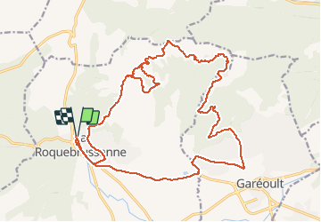
Trail Mountain bike of 26 km to be discovered at Provence-Alpes-Côte d'Azur, Var, La Roquebrussanne. This trail is proposed by pquilichini.

Description

Portage difficile entre la Barraque et les Barres des Charberts

Elevation profile

Photos

Points of interest

Point of interest La Roquebrussanne - Pas de la Nible - Photo
pquilichini
LA ROQUEBRUSSANNE 
Point of interest La Celle - La Barraque - Photo
pquilichini
LA CELLE 

Positioning

Country:
France
Region :
Provence-Alpes-Côte d'Azur
Department/Province :
Var
Municipality :
La Roquebrussanne
Location:
Unknown
Start:(UTM)
741178 ; 4803176 (31T) N.

Trails nearby

Trail Walking Mazaugues - Mazaugues 21.4.24 - Photo
Walking
GUIDE
fredetpascale

Walking

Medium
(1)
Mazaugues, Provence-Alpes-Côte d'Azur, Var, France
11.1 km | 17.8 km-effort
4h 0min
Yes
Trail Walking Néoules - Neoules crête 19,5 km - Photo
Walking
GUIDE
rvapeldo

Walking

Medium
Néoules, Provence-Alpes-Côte d'Azur, Var, France
19.5 km | 27 km-effort
7h 34min
Yes
Trail Walking La Roquebrussanne - La Roquebrussane trace réelle - Photo
Walking
GUIDE
jouans

Walking

Very difficult
La Roquebrussanne, Provence-Alpes-Côte d'Azur, Var, France
19.9 km | 32 km-effort
7h 12min
Yes
Trail Walking La Roquebrussanne - SityTrail - 2718180 - baume-fere-font-coulette-croix-de-berard - Photo
Walking
GUIDE
affinetataille

Walking

Medium
La Roquebrussanne, Provence-Alpes-Côte d'Azur, Var, France
14.4 km | 22 km-effort
6h 0min
Yes
Trail Walking Mazaugues - le Mourre d'Agnis au départ du Caucadis - Photo
Walking
GUIDE
amiral13

Walking

Difficult
Mazaugues, Provence-Alpes-Côte d'Azur, Var, France
17.6 km | 27 km-effort
7h 8min
Yes
Trail Walking Mazaugues - Mazaugues le vallon de l'Herbette - Photo
Walking
martinemarie

Walking

Medium
(2)
Mazaugues, Provence-Alpes-Côte d'Azur, Var, France
12.2 km | 18.8 km-effort
7h 27min
Yes
Trail Walking La Roquebrussanne - la montagne de la Loube - Photo
Walking
GUIDE
amiral13

Walking

Medium
La Roquebrussanne, Provence-Alpes-Côte d'Azur, Var, France
13.5 km | 21 km-effort
5h 30min
Yes
Trail Walking La Celle - L'Escarelle 1 - Photo
Walking
fains-marche

Walking

Easy
(1)
La Celle, Provence-Alpes-Côte d'Azur, Var, France
3.6 km | 5 km-effort
3h 10min
Yes
Trail Walking La Roquebrussanne - La Roquebrussane-Jas du murier - Photo
Walking
francisdean

Walking

Medium
(1)
La Roquebrussanne, Provence-Alpes-Côte d'Azur, Var, France
18.4 km | 25 km-effort
5h 21min
Yes


Close
My subscriptions