![](/images/other/stat-length.png)
![Trail Walking Saint-Rémy-de-Chargnat - St_Remy_Pic_Usson - Photo](https://media.geolcdn.com/t/1900/400/04fb18f3-77d1-43e8-809b-31619340b4d8.jpg&format=pjpeg&maxdim=2)
St_Remy_Pic_Usson
jagarnier
User GUIDE
![Length](/images/other/stat-length.png)
Length
10.2 km
![Max alt](https://static1.geolcdn.com/siteimages/upload/files/1508320355ic_sort_altitude_max_24dp.png)
Max alt
595 m
![Uphill gradient](https://static1.geolcdn.com/siteimages/upload/files/1508320355ic_sort_den_pos_24dp.png)
Uphill gradient
270 m
![Km-Effort](/images/other/stat-length.png)
Km-Effort
13.8 km
![Min alt](https://static1.geolcdn.com/siteimages/upload/files/1508320355ic_sort_altitude_min_24dp.png)
Min alt
379 m
![Downhill gradient](https://static1.geolcdn.com/siteimages/upload/files/1508320355ic_sort_den_neg_24dp.png)
Downhill gradient
270 m
![Boucle](https://static1.geolcdn.com/siteimages/upload/files/16400158638029165_repeat_loop_refresh_sync_direction_icon.png)
Boucle
Yes
Creation date :
2018-04-17 10:19:52.24
Updated on :
2022-09-05 05:58:14.922
![Walking](https://static1.geolcdn.com/sitytour/trail-icons/101.png)
3h00
Difficulty : Easy
![Scan this QR Code to open this trail in the SityTrail application](https://capi.geolives.com/qq0zvz2zws4bq2lad0pu/sitytour/trails/843062/qr.png?size=200)
FREE GPS app for hiking
About
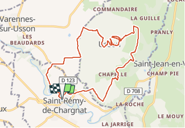
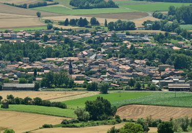
Trail Walking of 10.2 km to be discovered at Auvergne-Rhône-Alpes, Puy-de-Dôme, Saint-Rémy-de-Chargnat. This trail is proposed by jagarnier.
Description
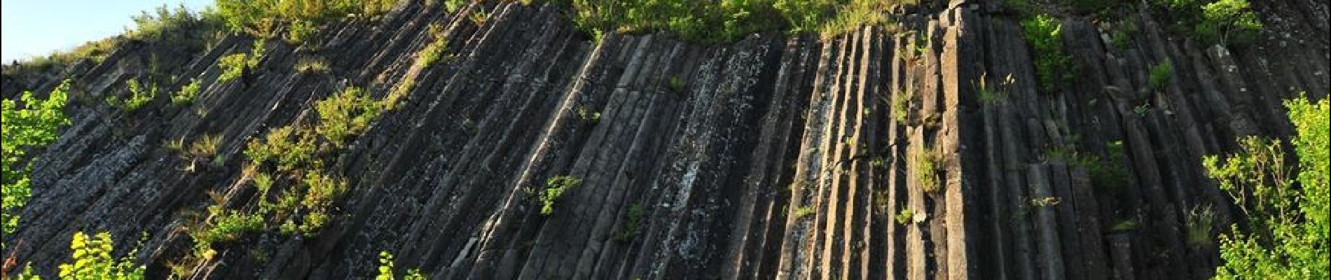
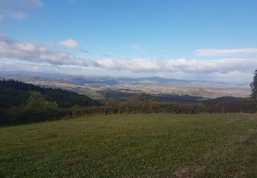
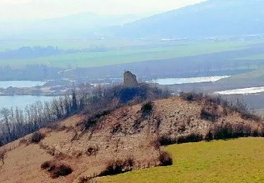
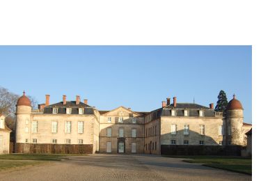
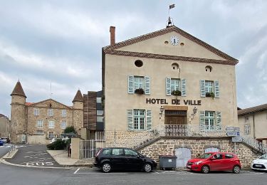
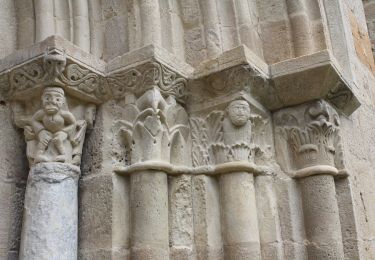
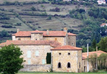
Usson village perché, son église, ses orgues basaltiques et son pic alimentent la curiosité des randonneurs. Les panoramas sur les monts Dore et la chaîne des Puys n’en sont pas moins remarquables.
Positioning
Country:
France
Region :
Auvergne-Rhône-Alpes
Department/Province :
Puy-de-Dôme
Municipality :
Saint-Rémy-de-Chargnat
Location:
Unknown
Start:(Dec)
Start:(UTM)
525156 ; 5040120 (31T) N.
Comments
Trails nearby
![Trail Motor Issoire - monboissiers 2 - Photo](https://media.geolcdn.com/t/375/260/ext.jpg?maxdim=2&url=https%3A%2F%2Fservices.sitytrail.com%2FGeolivesWS%2FDownloadMedia.ashx%3FTrailID%3D987209%26Media%3Dfix__20171022103942.jpg)
![Motor Motor](https://static1.geolcdn.com/sitytour/trail-icons/400.png)
monboissiers 2
Motor
Medium
(1)
Issoire,
Auvergne-Rhône-Alpes,
Puy-de-Dôme,
France
![](/images/other/stat-length.png)
101 km | 129 km-effort
3h 0min
![](https://static1.geolcdn.com/siteimages/upload/files/16400158638029165_repeat_loop_refresh_sync_direction_icon.png)
Yes
![Trail Walking Brenat - Brenat_Tour_Gevillat - Photo](https://media.geolcdn.com/t/375/260/2b9dba0d-44c9-4336-a13d-50587f665150.jpg&format=jpg&maxdim=2)
![Walking Walking](https://static1.geolcdn.com/sitytour/trail-icons/101.png)
Brenat_Tour_Gevillat
Walking
Easy
(1)
Brenat,
Auvergne-Rhône-Alpes,
Puy-de-Dôme,
France
![](/images/other/stat-length.png)
9.3 km | 11.9 km-effort
2h 45min
![](https://static1.geolcdn.com/siteimages/upload/files/16400158638029165_repeat_loop_refresh_sync_direction_icon.png)
Yes
![Trail Walking Les Pradeaux - De l'Allier à l'Ailloux - Photo](https://media.geolcdn.com/t/375/260/ext.jpg?maxdim=2&url=https%3A%2F%2Fservices.sitytrail.com%2FGeolivesWS%2FDownloadMedia.ashx%3FTrailID%3D102201%26Media%3D2601_1.jpg)
![Walking Walking](https://static1.geolcdn.com/sitytour/trail-icons/101.png)
De l'Allier à l'Ailloux
Walking
Medium
(1)
Les Pradeaux,
Auvergne-Rhône-Alpes,
Puy-de-Dôme,
France
![](/images/other/stat-length.png)
11.5 km | 13.1 km-effort
3h 0min
![](https://static1.geolcdn.com/siteimages/upload/files/16400158638029165_repeat_loop_refresh_sync_direction_icon.png)
Yes
![Trail On foot Sauxillanges - La Vallee de Civadoux - Photo](https://media.geolcdn.com/t/375/260/b4f7319b-3713-42b9-8b0d-6d7343ec86a5.jpeg&format=jpg&maxdim=2)
![On foot On foot](https://static1.geolcdn.com/sitytour/trail-icons/100.png)
La Vallee de Civadoux
On foot
Easy
Sauxillanges,
Auvergne-Rhône-Alpes,
Puy-de-Dôme,
France
![](/images/other/stat-length.png)
12.5 km | 19.5 km-effort
4h 26min
![](https://static1.geolcdn.com/siteimages/upload/files/16400158638029165_repeat_loop_refresh_sync_direction_icon.png)
Yes
![Trail On foot Lamontgie - Notre-Dame de Mailhat - Photo](https://media.geolcdn.com/t/375/260/8569347c-98a0-4a8f-9e69-27a1e8ebd4a8.jpeg&format=jpg&maxdim=2)
![On foot On foot](https://static1.geolcdn.com/sitytour/trail-icons/100.png)
Notre-Dame de Mailhat
On foot
Easy
Lamontgie,
Auvergne-Rhône-Alpes,
Puy-de-Dôme,
France
![](/images/other/stat-length.png)
8.4 km | 10.5 km-effort
2h 23min
![](https://static1.geolcdn.com/siteimages/upload/files/16400158638029165_repeat_loop_refresh_sync_direction_icon.png)
Yes
![Trail On foot Saint-Martin-des-Plains - Vallee de parcelles - Photo](https://media.geolcdn.com/t/375/260/c8678a81-89dc-4bd7-aa82-46bb9b00d226.jpeg&format=jpg&maxdim=2)
![On foot On foot](https://static1.geolcdn.com/sitytour/trail-icons/100.png)
Vallee de parcelles
On foot
Easy
Saint-Martin-des-Plains,
Auvergne-Rhône-Alpes,
Puy-de-Dôme,
France
![](/images/other/stat-length.png)
11.3 km | 13.8 km-effort
3h 8min
![](https://static1.geolcdn.com/siteimages/upload/files/16400158638029165_repeat_loop_refresh_sync_direction_icon.png)
Yes
![Trail On foot Usson - Le Pic d'Usson - Photo](https://media.geolcdn.com/t/375/260/6a96298d-c1d0-4fd4-b2cd-7460048c5b43.jpeg&format=jpg&maxdim=2)
![On foot On foot](https://static1.geolcdn.com/sitytour/trail-icons/100.png)
Le Pic d'Usson
On foot
Easy
Usson,
Auvergne-Rhône-Alpes,
Puy-de-Dôme,
France
![](/images/other/stat-length.png)
7.7 km | 9.6 km-effort
2h 11min
![](https://static1.geolcdn.com/siteimages/upload/files/16400158638029165_repeat_loop_refresh_sync_direction_icon.png)
No
![Trail On foot Brenat - La Tour de Gevillat - Photo](https://media.geolcdn.com/t/375/260/12927b2d-86e8-4e4a-bbac-13d0164d4024.jpeg&format=jpg&maxdim=2)
![On foot On foot](https://static1.geolcdn.com/sitytour/trail-icons/100.png)
La Tour de Gevillat
On foot
Easy
Brenat,
Auvergne-Rhône-Alpes,
Puy-de-Dôme,
France
![](/images/other/stat-length.png)
9.8 km | 12.6 km-effort
2h 52min
![](https://static1.geolcdn.com/siteimages/upload/files/16400158638029165_repeat_loop_refresh_sync_direction_icon.png)
Yes
![Trail Walking Nonette-Orsonnette - Nonette_Val_Allier - Photo](https://media.geolcdn.com/t/375/260/6af492ac-412f-4f8d-b1d7-92987ee0d659.jpg&format=jpg&maxdim=2)
![Walking Walking](https://static1.geolcdn.com/sitytour/trail-icons/101.png)
Nonette_Val_Allier
Walking
Medium
(1)
Nonette-Orsonnette,
Auvergne-Rhône-Alpes,
Puy-de-Dôme,
France
![](/images/other/stat-length.png)
9.9 km | 13.4 km-effort
3h 0min
![](https://static1.geolcdn.com/siteimages/upload/files/16400158638029165_repeat_loop_refresh_sync_direction_icon.png)
Yes