Trail Walking Châtres - Chatres (21-10-2017) Matin - Photo

Chatres (21-10-2017) Matin

© OpenStreetMap contributors
Length
Length
11.7 km
Max alt
Max alt
338 m
Uphill gradient
Uphill gradient
321 m
Km-Effort
Km-Effort  
15.9 km
Min alt
Min alt
173 m
Downhill gradient
Downhill gradient
318 m
Boucle
Boucle
Yes
Creation date :
2018-04-17 00:06:30.16
Updated on :
2018-04-17 00:06:30.16

(0 Reviews)

Walking
Walking
3h00
Difficulty : Easy

Scan this QR Code to open this trail in the SityTrail application

FREE GPS app for hiking

Logo SityTrail SityTrail

IGN / Geographical institutes

Download SityTrail from the App Store Download SityTrail from Google Play

Logo SityTrail SityTrail World

The world is yours!

Download SityTrail from the App Store Download SityTrail from Google Play Download SityTrail on Huawei AppGallery

About

Trail Walking of 11.7 km to be discovered at New Aquitaine, Dordogne, Châtres. This trail is proposed by godardenys.

Elevation profile

Positioning

Country:
France
Region :
New Aquitaine
Department/Province :
Dordogne
Municipality :
Châtres
Location:
Unknown
Start:(UTM)
358229 ; 5004931 (31T) N.

Comments

Please log in to post a review or rate the element


Randonnée à éviter, au cours de celle-ci, nous nous sommes engagés sur deux chemins qui se perdent dans les bois et pas praticables. S'abstenir de publier des randonnées pas fiables, ne pas oublier que des familles avec des enfants peuvent s'engager sur ses traces incertaines.


Trails nearby

Trail Walking Nailhac - Boucle de Nailhac  - Photo
Walking
swp648

Walking

Easy
Nailhac, New Aquitaine, Dordogne, France
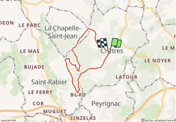
11.7 km | 14.9 km-effort
2h 54min
Yes
Trail Walking Peyrignac - boucle de la nuelle  - Photo
Walking
dmortier

Walking

Medium
Peyrignac, New Aquitaine, Dordogne, France
6.9 km | 9.3 km-effort
2h 14min
Yes
Trail Walking La Bachellerie - Boucle de la Bachellerie - Photo
Walking
CC.RIDER

Walking

Difficult
La Bachellerie, New Aquitaine, Dordogne, France
11.9 km | 15.8 km-effort
3h 35min
Yes
Trail Mountain bike La Chapelle-Saint-Jean - La Chapelle Saint Jean - Photo
Mountain bike
heyoka

Mountain bike

Easy
La Chapelle-Saint-Jean, New Aquitaine, Dordogne, France
11.7 km | 14.7 km-effort
3h 20min
No
Trail Walking Beauregard-de-Terrasson - track - Photo
Walking
swp648

Walking

Difficult
Beauregard-de-Terrasson, New Aquitaine, Dordogne, France
11.4 km | 15.7 km-effort
3h 34min
Yes
Trail Mountain bike La Chapelle-Saint-Jean - 2 - Photo
Mountain bike
christophe binet

Mountain bike

Very difficult
La Chapelle-Saint-Jean, New Aquitaine, Dordogne, France
41 km | 52 km-effort
1h 47min
No
Trail Walking Villac - 2023-03-10_16h12m44_UTF-8''%56%69%6C%6C%61%63%20%43%C3%B4%74%65%20%64%65%20%6C%61%20%47%65%6C%6C%61%64%65%2E%67%70%78 - Photo
Walking
swp648

Walking

Difficult
(1)
Villac, New Aquitaine, Dordogne, France
11 km | 16.9 km-effort
3h 50min
Yes
Trail Walking Villac - 2023-03-10_15h54m09_gpx-trace villac - Photo
Walking
swp648

Walking

Difficult
Villac, New Aquitaine, Dordogne, France
10 km | 12.6 km-effort
2h 51min
Yes
Trail Walking Villac - 2023-03-10_15h30m09_Cirkwi-Boucle_du_village_rouge - Photo
Walking
swp648

Walking

Difficult
(1)
Villac, New Aquitaine, Dordogne, France
8.1 km | 12.1 km-effort
2h 45min
Yes


Close
My subscriptions