Trail Walking Sologny - Sologny 2 - Photo
 GR192
GR192

User

© OpenStreetMap contributors
Length
Length
17.4 km
Max alt
Max alt
540 m
Uphill gradient
Uphill gradient
605 m
Km-Effort
Km-Effort  
25 km
Min alt
Min alt
267 m
Downhill gradient
Downhill gradient
604 m
Boucle
Boucle
Yes
Creation date :
2018-04-16 23:48:22.351
Updated on :
2018-04-16 23:48:22.351

(1 Reviews)

Walking
Walking
5h18
Difficulty : Easy

Scan this QR Code to open this trail in the SityTrail application

FREE GPS app for hiking

Logo SityTrail SityTrail

IGN / Geographical institutes

Download SityTrail from the App Store Download SityTrail from Google Play

Logo SityTrail SityTrail World

The world is yours!

Download SityTrail from the App Store Download SityTrail from Google Play Download SityTrail on Huawei AppGallery

About

Trail Walking of 17.4 km to be discovered at Bourgogne-Franche-Comté, Saône-et-Loire, Sologny. This trail is proposed by GR192.

Elevation profile

Positioning

Country:
France
Region :
Bourgogne-Franche-Comté
Department/Province :
Saône-et-Loire
Municipality :
Sologny
Location:
Unknown
Start:(UTM)
629662 ; 5135597 (31T) N.

Comments

Please log in to post a review or rate the element


table de pique nique vers château


Trails nearby

Trail Walking Pierreclos - Chateau de Pierreclos - Bourgogne - Aout 2012 - Photo
Walking
patrickmarchais

Walking

Easy
(1)
Pierreclos, Bourgogne-Franche-Comté, Saône-et-Loire, France
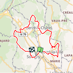
18.4 km | 26 km-effort
4h 39min
Yes
Trail Trail La Roche-Vineuse - Isidor le roi des roches - Photo
Trail
Eliiiise

Trail

Medium
(1)
La Roche-Vineuse, Bourgogne-Franche-Comté, Saône-et-Loire, France
26 km | 40 km-effort
3h 41min
Yes
Trail sport La Roche-Vineuse - Land art Somméré  - Photo
sport
Chachamaia71

sport

Very easy
La Roche-Vineuse, Bourgogne-Franche-Comté, Saône-et-Loire, France
5.1 km | 7.1 km-effort
Unknown
Yes
Trail Walking Milly-Lamartine - 2022-10-30_11h56m06_monsart-vergisson-solutre - Photo
Walking
pétoche

Walking

Difficult
(1)
Milly-Lamartine, Bourgogne-Franche-Comté, Saône-et-Loire, France
24 km | 37 km-effort
8h 19min
Yes
Trail Walking Verzé - la chapelle de saint criat  - Photo
Walking
darrisa

Walking

Difficult
Verzé, Bourgogne-Franche-Comté, Saône-et-Loire, France
9.3 km | 12.4 km-effort
3h 56min
Yes
Trail Walking Verzé - La Croix montmain verze - Photo
Walking
darrisa

Walking

Difficult
Verzé, Bourgogne-Franche-Comté, Saône-et-Loire, France
9 km | 12.4 km-effort
4h 14min
Yes
Trail Walking Igé - IGÉ (16 km - D. 420 m) - Photo
Walking
Thomasdanielle

Walking

Medium
(1)
Igé, Bourgogne-Franche-Comté, Saône-et-Loire, France
16.1 km | 22 km-effort
4h 54min
Yes
Trail Walking Sainte-Cécile - Le haut clunisois  - Photo
Walking
darrisa

Walking

Medium
Sainte-Cécile, Bourgogne-Franche-Comté, Saône-et-Loire, France
14.9 km | 19.6 km-effort
4h 0min
Yes
Trail Walking Sainte-Cécile - bourgvilain - Photo
Walking
darrisa

Walking

Difficult
Sainte-Cécile, Bourgogne-Franche-Comté, Saône-et-Loire, France
6.4 km | 9.4 km-effort
2h 15min
No


Close
My subscriptions