![](/images/other/stat-length.png)
![Trail Walking Labastide-de-Virac - salavas rieussec pont d'arc - Photo](https://media.geolcdn.com/t/1900/400/ext.pjpeg?maxdim=2&url=https%3A%2F%2Fstatic1.geolcdn.com%2Fsiteimages%2Fupload%2Ffiles%2F1553511878bg_sport_marche.png)
salavas rieussec pont d'arc
yves12
User
![Length](/images/other/stat-length.png)
Length
11.5 km
![Max alt](https://static1.geolcdn.com/siteimages/upload/files/1508320355ic_sort_altitude_max_24dp.png)
Max alt
273 m
![Uphill gradient](https://static1.geolcdn.com/siteimages/upload/files/1508320355ic_sort_den_pos_24dp.png)
Uphill gradient
321 m
![Km-Effort](/images/other/stat-length.png)
Km-Effort
15.8 km
![Min alt](https://static1.geolcdn.com/siteimages/upload/files/1508320355ic_sort_altitude_min_24dp.png)
Min alt
84 m
![Downhill gradient](https://static1.geolcdn.com/siteimages/upload/files/1508320355ic_sort_den_neg_24dp.png)
Downhill gradient
322 m
![Boucle](https://static1.geolcdn.com/siteimages/upload/files/16400158638029165_repeat_loop_refresh_sync_direction_icon.png)
Boucle
Yes
Creation date :
2017-09-25 00:00:00.0
Updated on :
2017-09-25 00:00:00.0
![Walking](https://static1.geolcdn.com/sitytour/trail-icons/101.png)
3h25
Difficulty : Difficult
![Scan this QR Code to open this trail in the SityTrail application](https://capi.geolives.com/qq0zvz2zws4bq2lad0pu/sitytour/trails/835223/qr.png?size=200)
FREE GPS app for hiking
About
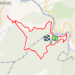
Trail Walking of 11.5 km to be discovered at Auvergne-Rhône-Alpes, Ardèche, Labastide-de-Virac. This trail is proposed by yves12.
Description
super descente du Rieussec avec passages difficiles puis remontée sur pont d'Arc et retour Salavas. Le sentier se perd au Pas des moines: privilégier vers Virac
Positioning
Country:
France
Region :
Auvergne-Rhône-Alpes
Department/Province :
Ardèche
Municipality :
Labastide-de-Virac
Location:
Unknown
Start:(Dec)
Start:(UTM)
612033 ; 4914681 (31T) N.
Comments
Trails nearby
![Trail Walking Vallon-Pont-d'Arc - vallon-chastelas - Photo](https://media.geolcdn.com/t/375/260/ext.jpg?maxdim=2&url=https%3A%2F%2Fservices.sitytrail.com%2FGeolivesWS%2FDownloadMedia.ashx%3FTrailID%3D973164%26Media%3D6277a14a-7c60-41f6-8938-7b9c5dd03a0e.jpg)
![Walking Walking](https://static1.geolcdn.com/sitytour/trail-icons/101.png)
vallon-chastelas
Walking
Easy
(3)
Vallon-Pont-d'Arc,
Auvergne-Rhône-Alpes,
Ardèche,
France
![](/images/other/stat-length.png)
4.5 km | 6.2 km-effort
1h 19min
![](https://static1.geolcdn.com/siteimages/upload/files/16400158638029165_repeat_loop_refresh_sync_direction_icon.png)
Yes
![Trail Walking Labastide-de-Virac - 07 gorges ardeche - Photo](https://media.geolcdn.com/t/375/260/ext.jpg?maxdim=2&url=https%3A%2F%2Fstatic1.geolcdn.com%2Fsiteimages%2Fupload%2Ffiles%2F1553511878bg_sport_marche.png)
![Walking Walking](https://static1.geolcdn.com/sitytour/trail-icons/101.png)
07 gorges ardeche
Walking
Easy
(1)
Labastide-de-Virac,
Auvergne-Rhône-Alpes,
Ardèche,
France
![](/images/other/stat-length.png)
13.7 km | 22 km-effort
5h 5min
![](https://static1.geolcdn.com/siteimages/upload/files/16400158638029165_repeat_loop_refresh_sync_direction_icon.png)
Yes
![Trail Walking Vallon-Pont-d'Arc - 26 grottes deroc Chauvet zel - Photo](https://media.geolcdn.com/t/375/260/7f04590c-50bd-4ffc-b58f-87ccb5055b84.jpg&format=jpg&maxdim=2)
![Walking Walking](https://static1.geolcdn.com/sitytour/trail-icons/101.png)
26 grottes deroc Chauvet zel
Walking
Very difficult
Vallon-Pont-d'Arc,
Auvergne-Rhône-Alpes,
Ardèche,
France
![](/images/other/stat-length.png)
12.3 km | 20 km-effort
4h 39min
![](https://static1.geolcdn.com/siteimages/upload/files/16400158638029165_repeat_loop_refresh_sync_direction_icon.png)
No
![Trail Walking Labastide-de-Virac - les gorges de l'Ardèche - Photo](https://media.geolcdn.com/t/375/260/22a42236-31e2-4521-b8d2-19cd765eb1ce.jpg&format=jpg&maxdim=2)
![Walking Walking](https://static1.geolcdn.com/sitytour/trail-icons/101.png)
les gorges de l'Ardèche
Walking
Medium
Labastide-de-Virac,
Auvergne-Rhône-Alpes,
Ardèche,
France
![](/images/other/stat-length.png)
8.9 km | 14.1 km-effort
5h 14min
![](https://static1.geolcdn.com/siteimages/upload/files/16400158638029165_repeat_loop_refresh_sync_direction_icon.png)
Yes
![Trail Walking Vallon-Pont-d'Arc - Vallon pont d'arc au bivouac du gournier - Photo](https://media.geolcdn.com/t/375/260/086bf84f-df3e-4a5f-9662-b644951d7f29.jpg&format=jpg&maxdim=2)
![Walking Walking](https://static1.geolcdn.com/sitytour/trail-icons/101.png)
Vallon pont d'arc au bivouac du gournier
Walking
Medium
Vallon-Pont-d'Arc,
Auvergne-Rhône-Alpes,
Ardèche,
France
![](/images/other/stat-length.png)
18.8 km | 31 km-effort
3h 45min
![](https://static1.geolcdn.com/siteimages/upload/files/16400158638029165_repeat_loop_refresh_sync_direction_icon.png)
No
![Mountain bike Mountain bike](https://static1.geolcdn.com/sitytour/trail-icons/202.png)
Vallon_Pont_d'Arc_20210712_092148
Mountain bike
Very easy
Vallon-Pont-d'Arc,
Auvergne-Rhône-Alpes,
Ardèche,
France
![](/images/other/stat-length.png)
27 km | 34 km-effort
Unknown
![](https://static1.geolcdn.com/siteimages/upload/files/16400158638029165_repeat_loop_refresh_sync_direction_icon.png)
Yes
![Trail Walking Salavas - 07 salavas pont de arc rieussec - Photo](https://media.geolcdn.com/t/375/260/187861b3-f925-444c-bb80-248c619c8cb5.jpg&format=jpg&maxdim=2)
![Walking Walking](https://static1.geolcdn.com/sitytour/trail-icons/101.png)
07 salavas pont de arc rieussec
Walking
Difficult
Salavas,
Auvergne-Rhône-Alpes,
Ardèche,
France
![](/images/other/stat-length.png)
16.4 km | 23 km-effort
7h 40min
![](https://static1.geolcdn.com/siteimages/upload/files/16400158638029165_repeat_loop_refresh_sync_direction_icon.png)
Yes
![Trail Walking Vallon-Pont-d'Arc - 07 grotte derocs chauvet - Photo](https://media.geolcdn.com/t/375/260/85789a19-d525-478e-9faa-7a8446c70e43.jpg&format=jpg&maxdim=2)
![Walking Walking](https://static1.geolcdn.com/sitytour/trail-icons/101.png)
07 grotte derocs chauvet
Walking
Difficult
Vallon-Pont-d'Arc,
Auvergne-Rhône-Alpes,
Ardèche,
France
![](/images/other/stat-length.png)
8.5 km | 14.5 km-effort
6h 18min
![](https://static1.geolcdn.com/siteimages/upload/files/16400158638029165_repeat_loop_refresh_sync_direction_icon.png)
Yes
![Mountain bike Mountain bike](https://static1.geolcdn.com/sitytour/trail-icons/202.png)
SityTrail - 2433385 - vtt-vallon-pont-arc-xpont-romain-et-dolmen-25-km
Mountain bike
Difficult
Vallon-Pont-d'Arc,
Auvergne-Rhône-Alpes,
Ardèche,
France
![](/images/other/stat-length.png)
24 km | 33 km-effort
Unknown
![](https://static1.geolcdn.com/siteimages/upload/files/16400158638029165_repeat_loop_refresh_sync_direction_icon.png)
No