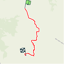
![](/images/other/stat-length.png)
![Trail Walking Tre Ville - 2017-09-05 Réf. Graffer-Groste-ref.Allimonta - Photo](https://media.geolcdn.com/t/1900/400/ext.pjpeg?maxdim=2&url=https%3A%2F%2Fservices.sitytrail.com%2FGeolivesWS%2FDownloadMedia.ashx%3FTrailID%3D832806%26Media%3Dfix__20170905200922.jpg)
2017-09-05 Réf. Graffer-Groste-ref.Allimonta
meunier.ph.
User
![Length](/images/other/stat-length.png)
![Max alt](https://static1.geolcdn.com/siteimages/upload/files/1508320355ic_sort_altitude_max_24dp.png)
![Uphill gradient](https://static1.geolcdn.com/siteimages/upload/files/1508320355ic_sort_den_pos_24dp.png)
![Km-Effort](/images/other/stat-length.png)
![Min alt](https://static1.geolcdn.com/siteimages/upload/files/1508320355ic_sort_altitude_min_24dp.png)
![Downhill gradient](https://static1.geolcdn.com/siteimages/upload/files/1508320355ic_sort_den_neg_24dp.png)
![Boucle](https://static1.geolcdn.com/siteimages/upload/files/16400158638029165_repeat_loop_refresh_sync_direction_icon.png)
![Walking](https://static1.geolcdn.com/sitytour/trail-icons/101.png)
5h21
Difficulty : Very difficult
![Scan this QR Code to open this trail in the SityTrail application](https://capi.geolives.com/qq0zvz2zws4bq2lad0pu/sitytour/trails/832806/qr.png?size=200)
FREE GPS app for hiking
About
Trail Walking of 10.5 km to be discovered at Trentino-Alto Adige/Südtirol, Provincia di Trento, Tre Ville. This trail is proposed by meunier.ph..
Description
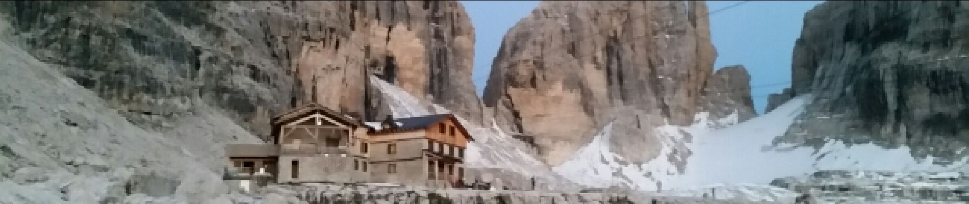
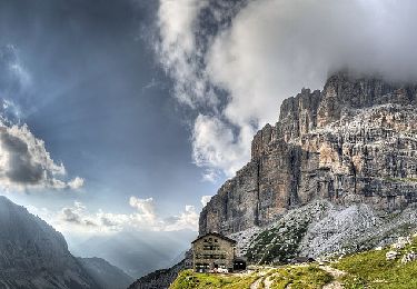
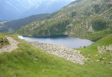
Parcours de Via Ferrata demandant un équipement spécifique et une certaine maîtrise de la haute montagne.
Départ du refuge Graffer: Via Ferrata Benini, Bocchetta Alto et Olivia Detassis et arrivée au ref. Alimonta.
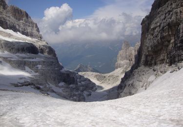
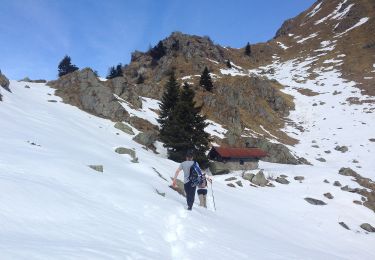
La trace GPS n'est pas précise surtout entre les parois très abruptes du parcours qui ne reçoivent pas le signal satellite.
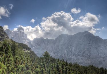
Très beau parcours.
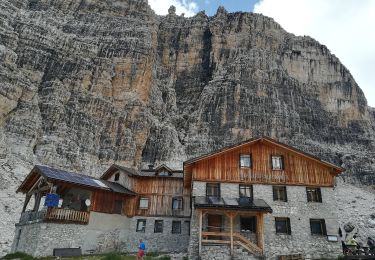
Les parties les plus exposées, comme dans la plupart des Vias des Dolomites, se situent dans certains passages non câblés.
Cela demande un pied sûr et une attention constante.
Positioning
Comments
Trails nearby
![Trail On foot Tre Ville - Sentiero](https://media.geolcdn.com/t/375/260/7369106a-5c81-41ec-8d49-f3a6ecbc8609.jpeg&format=jpg&maxdim=2)
![On foot On foot](https://static1.geolcdn.com/sitytour/trail-icons/100.png)
On foot
![](/images/other/stat-length.png)
![](https://static1.geolcdn.com/siteimages/upload/files/16400158638029165_repeat_loop_refresh_sync_direction_icon.png)
![Trail On foot Ville d'Anaunia - Via ferrata delle Bocchette](https://media.geolcdn.com/t/375/260/ffe87ce9-5fcb-4eba-b083-4e4365a3e81c.jpeg&format=jpg&maxdim=2)
![On foot On foot](https://static1.geolcdn.com/sitytour/trail-icons/100.png)
On foot
![](/images/other/stat-length.png)
![](https://static1.geolcdn.com/siteimages/upload/files/16400158638029165_repeat_loop_refresh_sync_direction_icon.png)
![Trail On foot Ville d'Anaunia - Via ferrata delle Palete - Photo](https://media.geolcdn.com/t/375/260/4fca5709-90bb-4975-869a-99a7dc9b585e.jpeg&format=jpg&maxdim=2)
![On foot On foot](https://static1.geolcdn.com/sitytour/trail-icons/100.png)
On foot
![](/images/other/stat-length.png)
![](https://static1.geolcdn.com/siteimages/upload/files/16400158638029165_repeat_loop_refresh_sync_direction_icon.png)
![Trail On foot Tre Ville - Via ferrata alpinistica](https://media.geolcdn.com/t/375/260/451c5a3f-de36-429c-9456-783cce8c692c.jpeg&format=jpg&maxdim=2)
![On foot On foot](https://static1.geolcdn.com/sitytour/trail-icons/100.png)
On foot
![](/images/other/stat-length.png)
![](https://static1.geolcdn.com/siteimages/upload/files/16400158638029165_repeat_loop_refresh_sync_direction_icon.png)
![Trail On foot Molveno - IT-O314 - Photo](https://media.geolcdn.com/t/375/260/9640fd8a-f8d2-460c-bc3a-7db0a7b04cee.jpeg&format=jpg&maxdim=2)
![On foot On foot](https://static1.geolcdn.com/sitytour/trail-icons/100.png)
On foot
![](/images/other/stat-length.png)
![](https://static1.geolcdn.com/siteimages/upload/files/16400158638029165_repeat_loop_refresh_sync_direction_icon.png)
![Trail On foot Pinzolo - Sentiero di Serodoli e Nambrone - Photo](https://media.geolcdn.com/t/375/260/6edeef40-9cfd-4c9c-b7a4-c042583aee21.jpeg&format=jpg&maxdim=2)
![On foot On foot](https://static1.geolcdn.com/sitytour/trail-icons/100.png)
On foot
![](/images/other/stat-length.png)
![](https://static1.geolcdn.com/siteimages/upload/files/16400158638029165_repeat_loop_refresh_sync_direction_icon.png)
![Trail On foot Pinzolo - IT-O277 - Photo](https://media.geolcdn.com/t/375/260/28a01e30-abc3-4693-bc51-c86d59b75049.jpeg&format=jpg&maxdim=2)
![On foot On foot](https://static1.geolcdn.com/sitytour/trail-icons/100.png)
On foot
![](/images/other/stat-length.png)
![](https://static1.geolcdn.com/siteimages/upload/files/16400158638029165_repeat_loop_refresh_sync_direction_icon.png)
![Trail On foot Tre Ville - Sentiero di Val Brenta - Photo](https://media.geolcdn.com/t/375/260/9191c4d9-7309-4534-ab50-52e58c32f6e2.jpeg&format=jpg&maxdim=2)
![On foot On foot](https://static1.geolcdn.com/sitytour/trail-icons/100.png)
On foot
![](/images/other/stat-length.png)
![](https://static1.geolcdn.com/siteimages/upload/files/16400158638029165_repeat_loop_refresh_sync_direction_icon.png)
![Trail On foot Tre Ville - Sentero della Corna Rosa - Photo](https://media.geolcdn.com/t/375/260/e00f656f-96bc-4fdb-8194-75dad693550b.jpeg&format=jpg&maxdim=2)
![On foot On foot](https://static1.geolcdn.com/sitytour/trail-icons/100.png)
On foot
![](/images/other/stat-length.png)
![](https://static1.geolcdn.com/siteimages/upload/files/16400158638029165_repeat_loop_refresh_sync_direction_icon.png)