Trail Walking Chef-Boutonne - chef_boutonne - Photo
 olaze
olaze

User

© OpenStreetMap contributors
Length
Length
8.1 km
Max alt
Max alt
86 m
Uphill gradient
Uphill gradient
40 m
Km-Effort
Km-Effort  
8.6 km
Min alt
Min alt
71 m
Downhill gradient
Downhill gradient
39 m
Boucle
Boucle
Yes
Creation date :
2017-09-03 00:00:00.0
Updated on :
2017-09-03 00:00:00.0

(0 Reviews)

Walking
Walking
1h56
Difficulty : Easy

Scan this QR Code to open this trail in the SityTrail application

FREE GPS app for hiking

Logo SityTrail SityTrail

IGN / Geographical institutes

Download SityTrail from the App Store Download SityTrail from Google Play

Logo SityTrail SityTrail World

The world is yours!

Download SityTrail from the App Store Download SityTrail from Google Play Download SityTrail on Huawei AppGallery

About

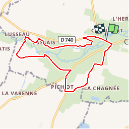
Trail Walking of 8.1 km to be discovered at New Aquitaine, Deux-Sèvres, Chef-Boutonne. This trail is proposed by olaze.

Description

Balade qui alliera découvertes patrimoniales et rencontre avec la nature. Puits, Porche, Eglise, Château de Javarzay, Arbre remarquable, Fontaine - lavoir, Bâtisse ancienne, Point de vue, Fontaine - lavoir, Logis - manoir, Logis - manoir, Pigeonnier. Départ Château de Javarzay.

Elevation profile

Positioning

Country:
France
Region :
New Aquitaine
Department/Province :
Deux-Sèvres
Municipality :
Chef-Boutonne
Location:
Chef-Boutonne
Start:(UTM)
725386 ; 5110314 (30T) N.

Trails nearby

Trail Walking Chef-Boutonne - La Somptueuse - Photo
Walking
reva17

Walking

Easy
Chef-Boutonne, New Aquitaine, Deux-Sèvres, France
11.7 km | 13.4 km-effort
2h 30min
Yes
Trail Walking Chef-Boutonne - La Somptueuse 2 - Photo
Walking
reva17

Walking

Easy
(1)
Chef-Boutonne, New Aquitaine, Deux-Sèvres, France
10 km | 11.2 km-effort
2h 30min
Yes


Close
My subscriptions