![](/images/other/stat-length.png)
![Trail Cycle Metz - Maison du vélo- Devant-les-Ponts - Photo](https://media.geolcdn.com/t/1900/400/ext.pjpeg?maxdim=2&url=https%3A%2F%2Fstatic1.geolcdn.com%2Fsiteimages%2Fupload%2Ffiles%2F1524743154velo.jpg)
Maison du vélo- Devant-les-Ponts
edmondnagel
User
![Length](/images/other/stat-length.png)
Length
20 km
![Max alt](https://static1.geolcdn.com/siteimages/upload/files/1508320355ic_sort_altitude_max_24dp.png)
Max alt
258 m
![Uphill gradient](https://static1.geolcdn.com/siteimages/upload/files/1508320355ic_sort_den_pos_24dp.png)
Uphill gradient
221 m
![Km-Effort](/images/other/stat-length.png)
Km-Effort
23 km
![Min alt](https://static1.geolcdn.com/siteimages/upload/files/1508320355ic_sort_altitude_min_24dp.png)
Min alt
159 m
![Downhill gradient](https://static1.geolcdn.com/siteimages/upload/files/1508320355ic_sort_den_neg_24dp.png)
Downhill gradient
221 m
![Boucle](https://static1.geolcdn.com/siteimages/upload/files/16400158638029165_repeat_loop_refresh_sync_direction_icon.png)
Boucle
Yes
Creation date :
2017-08-28 00:00:00.0
Updated on :
2017-08-28 00:00:00.0
![Cycle](https://static1.geolcdn.com/sitytour/trail-icons/200.png)
1h21
Difficulty : Medium
![Scan this QR Code to open this trail in the SityTrail application](https://capi.geolives.com/qq0zvz2zws4bq2lad0pu/sitytour/trails/819117/qr.png?size=200)
FREE GPS app for hiking
About
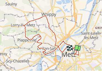
Trail Cycle of 20 km to be discovered at Grand Est, Moselle, Metz. This trail is proposed by edmondnagel.
Description
Départ Maison du Vélo direction Devant-Les-Ponts en passant par les remparts, le chemin noir, Woippy, Lorry-Les-Metz, Devant-Les-Ponts, Le belvédère avec une superbe vue sur Metz, retour par Le Ban Saint Martin, le véloroute Charles le Téméraire
Positioning
Country:
France
Region :
Grand Est
Department/Province :
Moselle
Municipality :
Metz
Location:
Unknown
Start:(Dec)
Start:(UTM)
294417 ; 5444591 (32U) N.
Comments
Trails nearby
![Trail Walking Plappeville - Saint Quentin - Photo](https://media.geolcdn.com/t/375/260/ext.jpg?maxdim=2&url=https%3A%2F%2Fservices.sitytrail.com%2FGeolivesWS%2FDownloadMedia.ashx%3FTrailID%3D159776%26Media%3D20121024120133.jpg)
![Walking Walking](https://static1.geolcdn.com/sitytour/trail-icons/101.png)
Saint Quentin
Walking
Medium
(1)
Plappeville,
Grand Est,
Moselle,
France
![](/images/other/stat-length.png)
6.9 km | 9.2 km-effort
1h 59min
![](https://static1.geolcdn.com/siteimages/upload/files/16400158638029165_repeat_loop_refresh_sync_direction_icon.png)
Yes
![Trail Walking Plappeville - Autour du fort de Plappeville. - Photo](https://media.geolcdn.com/t/375/260/ext.jpg?maxdim=2&url=https%3A%2F%2Fservices.sitytrail.com%2FGeolivesWS%2FDownloadMedia.ashx%3FTrailID%3D147559%26Media%3D20120816102740.jpg)
![Walking Walking](https://static1.geolcdn.com/sitytour/trail-icons/101.png)
Autour du fort de Plappeville.
Walking
Easy
(1)
Plappeville,
Grand Est,
Moselle,
France
![](/images/other/stat-length.png)
8.9 km | 11 km-effort
2h 55min
![](https://static1.geolcdn.com/siteimages/upload/files/16400158638029165_repeat_loop_refresh_sync_direction_icon.png)
Yes
![Trail On foot Metz - Circuit des sentiers de Queuleu - Photo](https://media.geolcdn.com/t/375/260/e8f5cc79-0435-4c0e-abc8-879d05da612b.jpeg&format=jpg&maxdim=2)
![On foot On foot](https://static1.geolcdn.com/sitytour/trail-icons/100.png)
Circuit des sentiers de Queuleu
On foot
Easy
Metz,
Grand Est,
Moselle,
France
![](/images/other/stat-length.png)
4.5 km | 5.2 km-effort
1h 10min
![](https://static1.geolcdn.com/siteimages/upload/files/16400158638029165_repeat_loop_refresh_sync_direction_icon.png)
Yes
![Trail On foot Scy-Chazelles - Circuit du Tour du Mont St Quentin - Photo](https://media.geolcdn.com/t/375/260/0227a6bb-ecc7-41f2-b92a-b603e3858c5b.jpeg&format=jpg&maxdim=2)
![On foot On foot](https://static1.geolcdn.com/sitytour/trail-icons/100.png)
Circuit du Tour du Mont St Quentin
On foot
Easy
Scy-Chazelles,
Grand Est,
Moselle,
France
![](/images/other/stat-length.png)
4.9 km | 6.7 km-effort
1h 31min
![](https://static1.geolcdn.com/siteimages/upload/files/16400158638029165_repeat_loop_refresh_sync_direction_icon.png)
No
![Walking Walking](https://static1.geolcdn.com/sitytour/trail-icons/101.png)
20210723 - METZ - Promenade des remparts - 6 Km
Walking
Very easy
Metz,
Grand Est,
Moselle,
France
![](/images/other/stat-length.png)
5.7 km | 6.6 km-effort
1h 45min
![](https://static1.geolcdn.com/siteimages/upload/files/16400158638029165_repeat_loop_refresh_sync_direction_icon.png)
Yes
![Trail Mountain bike Metz - MetzGare-PAM - Photo](https://media.geolcdn.com/t/375/260/ext.jpg?maxdim=2&url=https%3A%2F%2Fstatic1.geolcdn.com%2Fsiteimages%2Fupload%2Ffiles%2F1524743154velo.jpg)
![Mountain bike Mountain bike](https://static1.geolcdn.com/sitytour/trail-icons/202.png)
MetzGare-PAM
Mountain bike
Easy
(1)
Metz,
Grand Est,
Moselle,
France
![](/images/other/stat-length.png)
30 km | 33 km-effort
Unknown
![](https://static1.geolcdn.com/siteimages/upload/files/16400158638029165_repeat_loop_refresh_sync_direction_icon.png)
No
![Trail Walking Longeville-lès-Metz - Metz - Les fortifications & 🎅🎄 - Photo](https://media.geolcdn.com/t/375/260/78c4f220-2684-42e2-8e51-0cc7754dd491.jpg&format=jpg&maxdim=2)
![Walking Walking](https://static1.geolcdn.com/sitytour/trail-icons/101.png)
Metz - Les fortifications & 🎅🎄
Walking
Easy
Longeville-lès-Metz,
Grand Est,
Moselle,
France
![](/images/other/stat-length.png)
11.2 km | 12.9 km-effort
2h 41min
![](https://static1.geolcdn.com/siteimages/upload/files/16400158638029165_repeat_loop_refresh_sync_direction_icon.png)
Yes
![Trail Walking Longeville-lès-Metz - 🎅🎄 Noël à Metz - Photo](https://media.geolcdn.com/t/375/260/5af36f19-04a2-474a-9a82-8a9aed35e003.jpg&format=jpg&maxdim=2)
![Walking Walking](https://static1.geolcdn.com/sitytour/trail-icons/101.png)
🎅🎄 Noël à Metz
Walking
Easy
Longeville-lès-Metz,
Grand Est,
Moselle,
France
![](/images/other/stat-length.png)
14.5 km | 16.5 km-effort
3h 54min
![](https://static1.geolcdn.com/siteimages/upload/files/16400158638029165_repeat_loop_refresh_sync_direction_icon.png)
Yes
![Trail Equestrian Woippy - Vers chez Sam - Photo](https://media.geolcdn.com/t/375/260/ext.jpg?maxdim=2&url=https%3A%2F%2Fstatic1.geolcdn.com%2Fsiteimages%2Fupload%2Ffiles%2F1524743154cheval.jpg)
![Equestrian Equestrian](https://static1.geolcdn.com/sitytour/trail-icons/300.png)
Vers chez Sam
Equestrian
Very easy
(1)
Woippy,
Grand Est,
Moselle,
France
![](/images/other/stat-length.png)
9.3 km | 12.3 km-effort
Unknown
![](https://static1.geolcdn.com/siteimages/upload/files/16400158638029165_repeat_loop_refresh_sync_direction_icon.png)
No