Trail Cycle Saint-Basile - 07 lamastre le cheylard - Photo
 randodyssée
randodyssée

User GUIDE

© OpenStreetMap contributors
Length
Length
67 km
Max alt
Max alt
990 m
Uphill gradient
Uphill gradient
1606 m
Km-Effort
Km-Effort  
89 km
Min alt
Min alt
375 m
Downhill gradient
Downhill gradient
1814 m
Boucle
Boucle
No
Creation date :
2018-04-16 21:39:49.466
Updated on :
2018-04-16 21:39:49.466

(0 Reviews)

Cycle
Cycle
5h02
Difficulty : Medium

Scan this QR Code to open this trail in the SityTrail application

FREE GPS app for hiking

Logo SityTrail SityTrail

IGN / Geographical institutes

Download SityTrail from the App Store Download SityTrail from Google Play

Logo SityTrail SityTrail World

The world is yours!

Download SityTrail from the App Store Download SityTrail from Google Play Download SityTrail on Huawei AppGallery

About

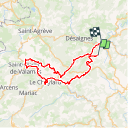
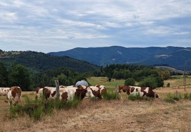
Trail Cycle of 67 km to be discovered at Auvergne-Rhône-Alpes, Ardèche, Saint-Basile. This trail is proposed by randodyssée.

Description

tres bel itiniraire 25.08.17

Elevation profile

Positioning

Country:
France
Region :
Auvergne-Rhône-Alpes
Department/Province :
Ardèche
Municipality :
Saint-Basile
Location:
Unknown
Start:(UTM)
623702 ; 4979909 (31T) N.

Trails nearby

Trail Walking Châteauneuf-de-Vernoux - Serre de la Roue - Photo
Walking
danaubrac

Walking

Easy
(1)
Châteauneuf-de-Vernoux, Auvergne-Rhône-Alpes, Ardèche, France
10.1 km | 14.9 km-effort
3h 7min
Yes
Trail sport Lamastre - Lamastre Montreynaud - Photo
sport
alinetpierre

sport

Very easy
(1)
Lamastre, Auvergne-Rhône-Alpes, Ardèche, France
17.7 km | 26 km-effort
Unknown
Yes
Trail sport Lamastre - Lamastre Desaignes - Photo
sport
alinetpierre

sport

Very easy
Lamastre, Auvergne-Rhône-Alpes, Ardèche, France
21 km | 29 km-effort
Unknown
Yes
Trail Walking Belsentes - Autour de la Chazalet  - Photo
Walking
GUIDE
nadinebondoux

Walking

Easy
(1)
Belsentes, Auvergne-Rhône-Alpes, Ardèche, France
8.1 km | 11.5 km-effort
2h 18min
Yes
Trail Walking Lamastre - urbilhac  - Photo
Walking
brigitte07

Walking

Very easy
(1)
Lamastre, Auvergne-Rhône-Alpes, Ardèche, France
6.5 km | 9.6 km-effort
1h 58min
Yes
Trail Mountain bike Désaignes - Autour de Combeneyre - Désaignes - Photo
Mountain bike
tracegps

Mountain bike

Medium
Désaignes, Auvergne-Rhône-Alpes, Ardèche, France
13.1 km | 18.3 km-effort
1h 30min
Yes
Trail Walking Désaignes - Autour de Combeneyre - Désaignes - Photo
Walking
tracegps

Walking

Medium
Désaignes, Auvergne-Rhône-Alpes, Ardèche, France
13.1 km | 18.3 km-effort
3h 0min
Yes
Trail Walking Désaignes - La Terrasse - Désaignes - Photo
Walking
tracegps

Walking

Medium
Désaignes, Auvergne-Rhône-Alpes, Ardèche, France
13.3 km | 21 km-effort
4h 0min
Yes
Trail Walking Désaignes - Les Sauvages - Desaignes - Photo
Walking
tracegps

Walking

Medium
Désaignes, Auvergne-Rhône-Alpes, Ardèche, France
12.3 km | 17.1 km-effort
3h 0min
Yes


Close
My subscriptions