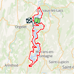
![](/images/other/stat-length.png)
![Trail Mountain bike La Tour-du-Meix - Tour du Lac de Vouglans - Photo](https://media.geolcdn.com/t/1900/400/ext.pjpeg?maxdim=2&url=https%3A%2F%2Fstatic1.geolcdn.com%2Fsiteimages%2Fupload%2Ffiles%2F1524743154velo.jpg)
Tour du Lac de Vouglans
fredhd25
User
![Length](/images/other/stat-length.png)
![Max alt](https://static1.geolcdn.com/siteimages/upload/files/1508320355ic_sort_altitude_max_24dp.png)
![Uphill gradient](https://static1.geolcdn.com/siteimages/upload/files/1508320355ic_sort_den_pos_24dp.png)
![Km-Effort](/images/other/stat-length.png)
![Min alt](https://static1.geolcdn.com/siteimages/upload/files/1508320355ic_sort_altitude_min_24dp.png)
![Downhill gradient](https://static1.geolcdn.com/siteimages/upload/files/1508320355ic_sort_den_neg_24dp.png)
![Boucle](https://static1.geolcdn.com/siteimages/upload/files/16400158638029165_repeat_loop_refresh_sync_direction_icon.png)
![Mountain bike](https://static1.geolcdn.com/sitytour/trail-icons/202.png)
6h36
Difficulty : Difficult
![Scan this QR Code to open this trail in the SityTrail application](https://capi.geolives.com/qq0zvz2zws4bq2lad0pu/sitytour/trails/816776/qr.png?size=200)
FREE GPS app for hiking
About
Trail Mountain bike of 82 km to be discovered at Bourgogne-Franche-Comté, Jura, La Tour-du-Meix. This trail is proposed by fredhd25.
Description
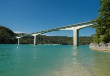
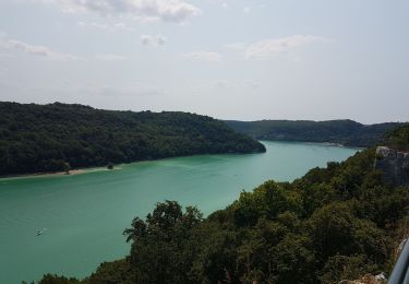
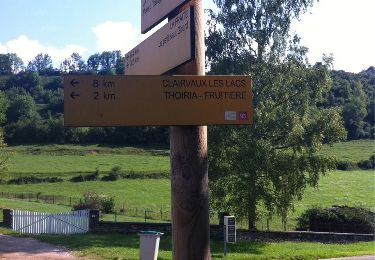
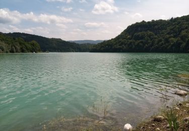
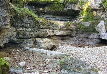
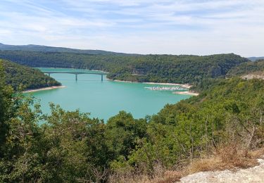
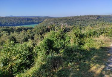
Le "Tour du Lac de Vouglans" est un itinéraire de Grande Randonnée de Pays de 82km, permettant une découverte entièrement centrée sur les attraits du lac de Vouglans : les marmites de géants à Pont de Poitte, le Pont de la Pyle, le barrage de Vouglans, les plages du Surchauffant, de Bellecin et de la Mercantine, etc. Il est aussi entièrement praticable et balisé pour le VTT
Positioning
Comments
Trails nearby
![Trail Mountain bike La Tour-du-Meix - Lac de Vouglans nord - La Tour-du-Meix - Photo](https://media.geolcdn.com/t/375/260/ext.jpg?maxdim=2&url=https%3A%2F%2Fservices.sitytrail.com%2FGeolivesWS%2FDownloadMedia.ashx%3FTrailID%3D316855%26Media%3D15926_6.jpg)
![Mountain bike Mountain bike](https://static1.geolcdn.com/sitytour/trail-icons/202.png)
Mountain bike
![](/images/other/stat-length.png)
![](https://static1.geolcdn.com/siteimages/upload/files/16400158638029165_repeat_loop_refresh_sync_direction_icon.png)
![Trail Walking La Tour-du-Meix - Vouglans depuis St Christophe - Photo](https://media.geolcdn.com/t/375/260/9bd36762-f5cb-4dda-8f17-5a560c7ed3be.jpg&format=jpg&maxdim=2)
![Walking Walking](https://static1.geolcdn.com/sitytour/trail-icons/101.png)
Walking
![](/images/other/stat-length.png)
![](https://static1.geolcdn.com/siteimages/upload/files/16400158638029165_repeat_loop_refresh_sync_direction_icon.png)
![Trail Walking Thoiria - Thoiria : grotte et cascades - Photo](https://media.geolcdn.com/t/375/260/ext.jpg?maxdim=2&url=https%3A%2F%2Fservices.sitytrail.com%2FGeolivesWS%2FDownloadMedia.ashx%3FTrailID%3D331269%26Media%3D20140805103940.jpg)
![Walking Walking](https://static1.geolcdn.com/sitytour/trail-icons/101.png)
Walking
![](/images/other/stat-length.png)
![](https://static1.geolcdn.com/siteimages/upload/files/16400158638029165_repeat_loop_refresh_sync_direction_icon.png)
![Trail Walking La Tour-du-Meix - St Christophe - Photo](https://media.geolcdn.com/t/375/260/0205dbdc-6013-448b-89e7-ce63ee72b2d9.jpg&format=jpg&maxdim=2)
![Walking Walking](https://static1.geolcdn.com/sitytour/trail-icons/101.png)
Walking
![](/images/other/stat-length.png)
![](https://static1.geolcdn.com/siteimages/upload/files/16400158638029165_repeat_loop_refresh_sync_direction_icon.png)
![Trail Walking Coyron - coyron - Photo](https://media.geolcdn.com/t/375/260/c2149d1f-ad6d-4d62-a8a2-21c37a8c1dbc.jpg&format=jpg&maxdim=2)
![Walking Walking](https://static1.geolcdn.com/sitytour/trail-icons/101.png)
Walking
![](/images/other/stat-length.png)
![](https://static1.geolcdn.com/siteimages/upload/files/16400158638029165_repeat_loop_refresh_sync_direction_icon.png)
![Trail Walking Coyron - coyron - Photo](https://media.geolcdn.com/t/375/260/e76682eb-658e-4c64-9c83-4ec8728bd6ed.jpg&format=jpg&maxdim=2)
![Walking Walking](https://static1.geolcdn.com/sitytour/trail-icons/101.png)
Walking
![](/images/other/stat-length.png)
![](https://static1.geolcdn.com/siteimages/upload/files/16400158638029165_repeat_loop_refresh_sync_direction_icon.png)
![Trail Mountain bike La Tour-du-Meix - Jura - La tour du Meix VTT - Photo](https://media.geolcdn.com/t/375/260/0c7a1581-db28-406e-977d-d4746d698e0b.jpg&format=jpg&maxdim=2)
![Mountain bike Mountain bike](https://static1.geolcdn.com/sitytour/trail-icons/202.png)
Mountain bike
![](/images/other/stat-length.png)
![](https://static1.geolcdn.com/siteimages/upload/files/16400158638029165_repeat_loop_refresh_sync_direction_icon.png)
![Trail On foot Dompierre-sur-Mont - Sentier Nature - Photo](https://media.geolcdn.com/t/375/260/1a3f07bd-d187-4f4e-ba44-a642a5d0288a.jpeg&format=jpg&maxdim=2)
![On foot On foot](https://static1.geolcdn.com/sitytour/trail-icons/100.png)
On foot
![](/images/other/stat-length.png)
![](https://static1.geolcdn.com/siteimages/upload/files/16400158638029165_repeat_loop_refresh_sync_direction_icon.png)
![Trail Walking Barésia-sur-l'Ain - Soucia - Photo](https://media.geolcdn.com/t/375/260/4b83286f-be60-4b6b-9800-68fb0978aa73.jpg&format=jpg&maxdim=2)
![Walking Walking](https://static1.geolcdn.com/sitytour/trail-icons/101.png)
Walking
![](/images/other/stat-length.png)
![](https://static1.geolcdn.com/siteimages/upload/files/16400158638029165_repeat_loop_refresh_sync_direction_icon.png)