![](/images/other/stat-length.png)
![Trail Cycle Vevey - Vevey - Nyon - Photo](https://media.geolcdn.com/t/1900/400/ext.pjpeg?maxdim=2&url=https%3A%2F%2Fservices.sitytrail.com%2FGeolivesWS%2FDownloadMedia.ashx%3FTrailID%3D814821%26Media%3Dfix__20170821181246.jpg)
Vevey - Nyon
karawatsj
User
![Length](/images/other/stat-length.png)
Length
70 km
![Max alt](https://static1.geolcdn.com/siteimages/upload/files/1508320355ic_sort_altitude_max_24dp.png)
Max alt
557 m
![Uphill gradient](https://static1.geolcdn.com/siteimages/upload/files/1508320355ic_sort_den_pos_24dp.png)
Uphill gradient
923 m
![Km-Effort](/images/other/stat-length.png)
Km-Effort
82 km
![Min alt](https://static1.geolcdn.com/siteimages/upload/files/1508320355ic_sort_altitude_min_24dp.png)
Min alt
370 m
![Downhill gradient](https://static1.geolcdn.com/siteimages/upload/files/1508320355ic_sort_den_neg_24dp.png)
Downhill gradient
877 m
![Boucle](https://static1.geolcdn.com/siteimages/upload/files/16400158638029165_repeat_loop_refresh_sync_direction_icon.png)
Boucle
No
Creation date :
2017-08-31 00:00:00.0
Updated on :
2017-08-31 00:00:00.0
![Cycle](https://static1.geolcdn.com/sitytour/trail-icons/200.png)
7h11
Difficulty : Difficult
![Scan this QR Code to open this trail in the SityTrail application](https://capi.geolives.com/qq0zvz2zws4bq2lad0pu/sitytour/trails/814821/qr.png?size=200)
FREE GPS app for hiking
About
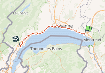
Trail Cycle of 70 km to be discovered at Vaud, District de la Riviera-Pays-d’Enhaut, Vevey. This trail is proposed by karawatsj.
Description
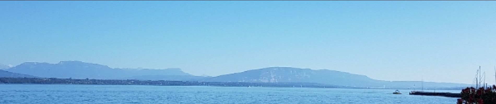
Mooie tocht langs de noordzijde van het meer van Genève (Lac Léman.
Door de wijngaarden van Vevey tot Lausanne. (steile hellingen)
Daarna tot Saint Prex en Alleman rustig verder langs de oevers.
Vanaf Allaman door de velden verder van het meer weg tot in Nyon
Positioning
Country:
Switzerland
Region :
Vaud
Department/Province :
District de la Riviera-Pays-d’Enhaut
Municipality :
Vevey
Location:
Unknown
Start:(Dec)
Start:(UTM)
334286 ; 5147429 (32T) N.
Comments
Trails nearby
![Trail Other activity Chardonne - y10_mont_pellerin - Photo](https://media.geolcdn.com/t/375/260/ext.jpg?maxdim=2&url=https%3A%2F%2Fstatic1.geolcdn.com%2Fsiteimages%2Fupload%2Ffiles%2F1545311037marcheuse_200dpi.jpg)
![Other activity Other activity](https://static1.geolcdn.com/sitytour/trail-icons/900.png)
y10_mont_pellerin
Other activity
Very easy
Chardonne,
Vaud,
District de la Riviera-Pays-d’Enhaut,
Switzerland
![](/images/other/stat-length.png)
9.1 km | 13.4 km-effort
2h 55min
![](https://static1.geolcdn.com/siteimages/upload/files/16400158638029165_repeat_loop_refresh_sync_direction_icon.png)
Yes
![Trail Walking Saint-Saphorin (Lavaux) - w10_01_lavaux - Photo](https://media.geolcdn.com/t/375/260/ext.jpg?maxdim=2&url=https%3A%2F%2Fstatic1.geolcdn.com%2Fsiteimages%2Fupload%2Ffiles%2F1553511878bg_sport_marche.png)
![Walking Walking](https://static1.geolcdn.com/sitytour/trail-icons/101.png)
w10_01_lavaux
Walking
Very easy
(2)
Saint-Saphorin (Lavaux),
Vaud,
District de Lavaux-Oron,
Switzerland
![](/images/other/stat-length.png)
11.1 km | 15.2 km-effort
3h 52min
![](https://static1.geolcdn.com/siteimages/upload/files/16400158638029165_repeat_loop_refresh_sync_direction_icon.png)
No
![Trail Cycle La Tour-de-Peilz - Vom Genfersee an den Bodensee - Photo](https://media.geolcdn.com/t/375/260/ext.jpg?maxdim=2&url=https%3A%2F%2Fstatic1.geolcdn.com%2Fsiteimages%2Fupload%2Ffiles%2F1524743154velo.jpg)
![Cycle Cycle](https://static1.geolcdn.com/sitytour/trail-icons/200.png)
Vom Genfersee an den Bodensee
Cycle
Very easy
La Tour-de-Peilz,
Vaud,
District de la Riviera-Pays-d’Enhaut,
Switzerland
![](/images/other/stat-length.png)
302 km | 466 km-effort
123h 6min
![](https://static1.geolcdn.com/siteimages/upload/files/16400158638029165_repeat_loop_refresh_sync_direction_icon.png)
No
![Trail Walking Chexbres - Chexbres: Balade dans le vignoble - Photo](https://media.geolcdn.com/t/375/260/ext.jpg?maxdim=2&url=https%3A%2F%2Fstatic1.geolcdn.com%2Fsiteimages%2Fupload%2Ffiles%2F1553511878bg_sport_marche.png)
![Walking Walking](https://static1.geolcdn.com/sitytour/trail-icons/101.png)
Chexbres: Balade dans le vignoble
Walking
Very easy
Chexbres,
Vaud,
District de Lavaux-Oron,
Switzerland
![](/images/other/stat-length.png)
4.7 km | 6.6 km-effort
Unknown
![](https://static1.geolcdn.com/siteimages/upload/files/16400158638029165_repeat_loop_refresh_sync_direction_icon.png)
No
![Trail Walking La Tour-de-Peilz - st_korea_tv1 - Photo](https://media.geolcdn.com/t/375/260/ext.jpg?maxdim=2&url=https%3A%2F%2Fstatic1.geolcdn.com%2Fsiteimages%2Fupload%2Ffiles%2F1553511878bg_sport_marche.png)
![Walking Walking](https://static1.geolcdn.com/sitytour/trail-icons/101.png)
st_korea_tv1
Walking
Very easy
La Tour-de-Peilz,
Vaud,
District de la Riviera-Pays-d’Enhaut,
Switzerland
![](/images/other/stat-length.png)
428 km | 1002 km-effort
29h 5min
![](https://static1.geolcdn.com/siteimages/upload/files/16400158638029165_repeat_loop_refresh_sync_direction_icon.png)
No
![Trail Walking La Tour-de-Peilz - st_ral_08_5 - Photo](https://media.geolcdn.com/t/375/260/ext.jpg?maxdim=2&url=https%3A%2F%2Fstatic1.geolcdn.com%2Fsiteimages%2Fupload%2Ffiles%2F1553511878bg_sport_marche.png)
![Walking Walking](https://static1.geolcdn.com/sitytour/trail-icons/101.png)
st_ral_08_5
Walking
Very easy
La Tour-de-Peilz,
Vaud,
District de la Riviera-Pays-d’Enhaut,
Switzerland
![](/images/other/stat-length.png)
116 km | 154 km-effort
6h 55min
![](https://static1.geolcdn.com/siteimages/upload/files/16400158638029165_repeat_loop_refresh_sync_direction_icon.png)
No
![Trail Nordic walking Chardonne - plein ciel - Photo](https://media.geolcdn.com/t/375/260/d5f8d0a1-ae32-418a-b2ee-bfd684fdbc5b.jpg&format=jpg&maxdim=2)
![Nordic walking Nordic walking](https://static1.geolcdn.com/sitytour/trail-icons/102.png)
plein ciel
Nordic walking
Very easy
Chardonne,
Vaud,
District de la Riviera-Pays-d’Enhaut,
Switzerland
![](/images/other/stat-length.png)
6.2 km | 9.9 km-effort
2h 16min
![](https://static1.geolcdn.com/siteimages/upload/files/16400158638029165_repeat_loop_refresh_sync_direction_icon.png)
Yes
![Trail On foot Chardonne - Sentier des Narcisses, Le Mont-Pèlerin - Photo](https://media.geolcdn.com/t/375/260/ext.jpg?maxdim=2&url=https%3A%2F%2Fstatic1.geolcdn.com%2Fsiteimages%2Fupload%2Ffiles%2F1545311037marcheuse_200dpi.jpg)
![On foot On foot](https://static1.geolcdn.com/sitytour/trail-icons/100.png)
Sentier des Narcisses, Le Mont-Pèlerin
On foot
Easy
Chardonne,
Vaud,
District de la Riviera-Pays-d’Enhaut,
Switzerland
![](/images/other/stat-length.png)
8.9 km | 13.8 km-effort
3h 8min
![](https://static1.geolcdn.com/siteimages/upload/files/16400158638029165_repeat_loop_refresh_sync_direction_icon.png)
Yes
![Trail On foot Chardonne - Mont-Pèlerin - Photo](https://media.geolcdn.com/t/375/260/ext.jpg?maxdim=2&url=https%3A%2F%2Fstatic1.geolcdn.com%2Fsiteimages%2Fupload%2Ffiles%2F1545311037marcheuse_200dpi.jpg)
![On foot On foot](https://static1.geolcdn.com/sitytour/trail-icons/100.png)
Mont-Pèlerin
On foot
Easy
Chardonne,
Vaud,
District de la Riviera-Pays-d’Enhaut,
Switzerland
![](/images/other/stat-length.png)
6.3 km | 10.4 km-effort
2h 21min
![](https://static1.geolcdn.com/siteimages/upload/files/16400158638029165_repeat_loop_refresh_sync_direction_icon.png)
Yes