Trail Other activity Veurey-Voroize - vorey - Photo
 joegcm
joegcm

User

© OpenStreetMap contributors
Length
Length
9.7 km
Max alt
Max alt
952 m
Uphill gradient
Uphill gradient
785 m
Km-Effort
Km-Effort  
20 km
Min alt
Min alt
195 m
Downhill gradient
Downhill gradient
785 m
Boucle
Boucle
Yes
Creation date :
2017-08-10 00:00:00.0
Updated on :
2017-08-10 00:00:00.0

(1 Reviews)

Other activity
Other activity
1h33
Difficulty : Medium

Scan this QR Code to open this trail in the SityTrail application

FREE GPS app for hiking

Logo SityTrail SityTrail

IGN / Geographical institutes

Download SityTrail from the App Store Download SityTrail from Google Play

Logo SityTrail SityTrail World

The world is yours!

Download SityTrail from the App Store Download SityTrail from Google Play Download SityTrail on Huawei AppGallery

About

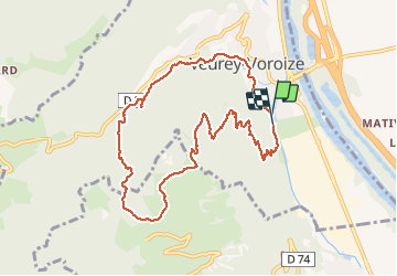
Trail Other activity of 9.7 km to be discovered at Auvergne-Rhône-Alpes, Isère, Veurey-Voroize. This trail is proposed by joegcm.

Elevation profile

Photos

Positioning

Country:
France
Region :
Auvergne-Rhône-Alpes
Department/Province :
Isère
Municipality :
Veurey-Voroize
Location:
Unknown
Start:(UTM)
705280 ; 5015869 (31T) N.

Comments

Please log in to post a review or rate the element


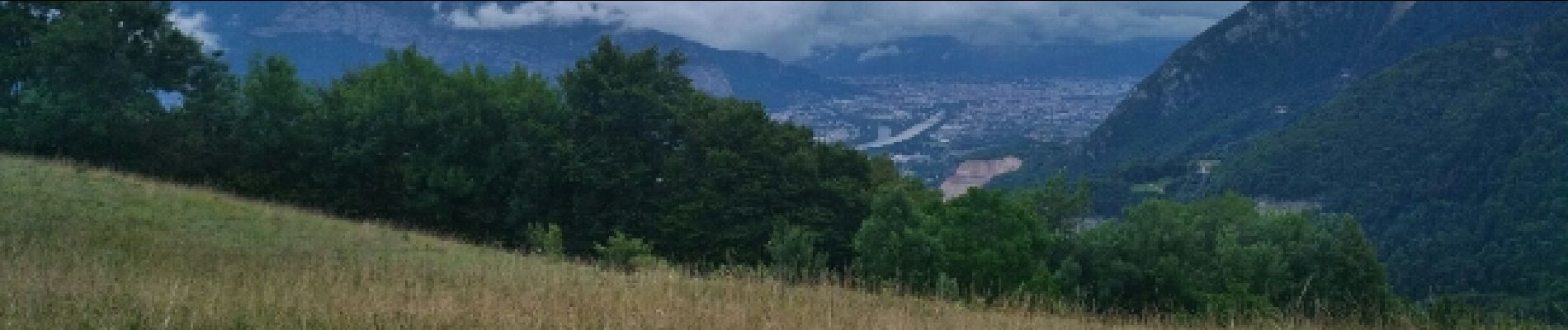
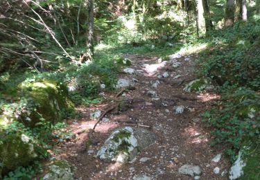
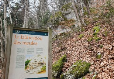
suivant les conditions climatiques, terrain difficilement pratiquable nécessitant des chaussures de trail adapté,arbres couché en travers des chemins par endroit.le départ le long du cour d'eau est assez sympa .


Trails nearby

Trail Walking Voreppe - Le Rocher de Lorzier, 1838m - Photo
Walking
tracegps

Walking

Medium
(2)
Voreppe, Auvergne-Rhône-Alpes, Isère, France
12.3 km | 25 km-effort
4h 45min
Yes
Trail Walking Voreppe - 38 voreppe - Photo
Walking
GUIDE
randodyssée

Walking

Medium
Voreppe, Auvergne-Rhône-Alpes, Isère, France
8.7 km | 16.8 km-effort
6h 25min
Yes
Trail Walking Voreppe - chalet des bannette par la cheminée et le pas de l'âne - Photo
Walking
GUIDE
nadd73

Walking

Medium
Voreppe, Auvergne-Rhône-Alpes, Isère, France
12.4 km | 25 km-effort
5h 25min
Yes
Trail Walking Voreppe - 38 la roize - Photo
Walking
GUIDE
randodyssée

Walking

Difficult
Voreppe, Auvergne-Rhône-Alpes, Isère, France
5.8 km | 10.5 km-effort
3h 17min
Yes
Trail Electric bike Voreppe - voreppe saint julien le grand raz voreppe - Photo
Electric bike
gaille38

Electric bike

Difficult
(1)
Voreppe, Auvergne-Rhône-Alpes, Isère, France
35 km | 50 km-effort
Unknown
Yes
Trail Walking Voreppe - Rocher de Lorzier - Photo
Walking
GUIDE
nadd73

Walking

Medium
Voreppe, Auvergne-Rhône-Alpes, Isère, France
12.8 km | 26 km-effort
5h 11min
Yes
Trail Walking La Sure en Chartreuse - 38 passieres charminelle zel 01.08.24 - Photo
Walking
GUIDE
randodyssée

Walking

Difficult
La Sure en Chartreuse, Auvergne-Rhône-Alpes, Isère, France
12.2 km | 23 km-effort
7h 14min
Yes
Trail Walking Voreppe - le trou au loup  - Photo
Walking
cousam

Walking

Difficult
Voreppe, Auvergne-Rhône-Alpes, Isère, France
8.5 km | 16.5 km-effort
6h 29min
Yes
Trail Walking Mont-Saint-Martin - la Meulière des Dauphins par Mont St Martin - Photo
Walking
Ak38

Walking

Medium
Mont-Saint-Martin, Auvergne-Rhône-Alpes, Isère, France
6.3 km | 11.1 km-effort
1h 52min
Yes


Close
My subscriptions