Trail Walking Halinghen - HautPicho-Halinghem - Photo
 Robert62
Robert62

User

© OpenStreetMap contributors
Length
Length
7.2 km
Max alt
Max alt
172 m
Uphill gradient
Uphill gradient
175 m
Km-Effort
Km-Effort  
9.5 km
Min alt
Min alt
82 m
Downhill gradient
Downhill gradient
176 m
Boucle
Boucle
Yes
Creation date :
2017-08-07 00:00:00.0
Updated on :
2022-10-03 18:32:38.332

(1 Reviews)

Walking
Walking
1h59
Difficulty : Medium

Scan this QR Code to open this trail in the SityTrail application

FREE GPS app for hiking

Logo SityTrail SityTrail

IGN / Geographical institutes

Download SityTrail from the App Store Download SityTrail from Google Play

Logo SityTrail SityTrail World

The world is yours!

Download SityTrail from the App Store Download SityTrail from Google Play Download SityTrail on Huawei AppGallery

About

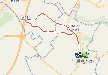
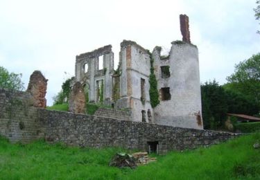
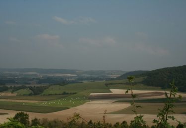
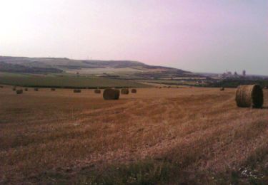
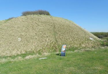
Trail Walking of 7.2 km to be discovered at Hauts-de-France, Pas-de-Calais, Halinghen. This trail is proposed by Robert62.

Description

Petite randonnée en boucle au départ de Halinghen

Elevation profile

Positioning

Country:
France
Region :
Hauts-de-France
Department/Province :
Pas-de-Calais
Municipality :
Halinghen
Location:
Unknown
Start:(UTM)
407307 ; 5606373 (31U) N.

Comments

Please log in to post a review or rate the element


Trails nearby

Trail Walking Frencq - Du Witrepin à la Dordonne - Frencq - Photo
Walking
tracegps

Walking

Difficult
(2)
Frencq, Hauts-de-France, Pas-de-Calais, France
13.1 km | 16.6 km-effort
3h 19min
Yes
Trail Walking Nesles - Mont Violette - Nesles - Photo
Walking
tracegps

Walking

Medium
(1)
Nesles, Hauts-de-France, Pas-de-Calais, France
11.6 km | 15.4 km-effort
3h 0min
Yes
Trail Walking Samer - Le chemin de Cappe - Samer  - Photo
Walking
tracegps

Walking

Medium
(1)
Samer, Hauts-de-France, Pas-de-Calais, France
10.7 km | 13.2 km-effort
3h 0min
Yes
Trail Walking Samer - Le Mont Corbeau - Samer - Photo
Walking
tracegps

Walking

Difficult
Samer, Hauts-de-France, Pas-de-Calais, France
10.1 km | 12.6 km-effort
3h 0min
Yes
Trail Mountain bike Samer - Le Haut Pichot - Samer - Photo
Mountain bike
tracegps

Mountain bike

Difficult
Samer, Hauts-de-France, Pas-de-Calais, France
32 km | 39 km-effort
3h 0min
Yes
Trail Walking Samer - Le Haut Pichot - Samer - Photo
Walking
tracegps

Walking

Difficult
Samer, Hauts-de-France, Pas-de-Calais, France
32 km | 39 km-effort
7h 0min
Yes
Trail Mountain bike Frencq - Du Witrepin à la Dordonne - Frencq - Photo
Mountain bike
tracegps

Mountain bike

Medium
Frencq, Hauts-de-France, Pas-de-Calais, France
13.1 km | 16.6 km-effort
1h 30min
Yes
Trail Walking Neufchâtel-Hardelot - De la Glaisière au Vouroux - Photo
Walking
tracegps

Walking

Medium
(1)
Neufchâtel-Hardelot, Hauts-de-France, Pas-de-Calais, France
15.4 km | 17.7 km-effort
3h 30min
Yes
Trail Walking Nesles - Sentier de la Motte Castrale - Nesles - Photo
Walking
tracegps

Walking

Easy
Nesles, Hauts-de-France, Pas-de-Calais, France
2.1 km | 2.8 km-effort
30min
Yes


Close
My subscriptions