Trail Walking Poule-les-Écharmeaux - Les Echarmeaux (18km D. 574) m - Photo

Les Echarmeaux (18km D. 574) m

© OpenStreetMap contributors
Length
Length
18.1 km
Max alt
Max alt
883 m
Uphill gradient
Uphill gradient
589 m
Km-Effort
Km-Effort  
26 km
Min alt
Min alt
493 m
Downhill gradient
Downhill gradient
590 m
Boucle
Boucle
Yes
Creation date :
2017-08-07 00:00:00.0
Updated on :
2017-08-07 00:00:00.0

(0 Reviews)

Walking
Walking
5h25
Difficulty : Medium

Scan this QR Code to open this trail in the SityTrail application

FREE GPS app for hiking

Logo SityTrail SityTrail

IGN / Geographical institutes

Download SityTrail from the App Store Download SityTrail from Google Play

Logo SityTrail SityTrail World

The world is yours!

Download SityTrail from the App Store Download SityTrail from Google Play Download SityTrail on Huawei AppGallery

About

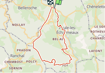
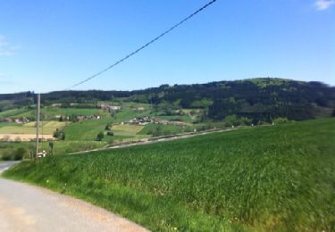
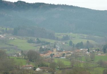
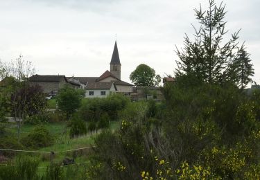
Trail Walking of 18.1 km to be discovered at Auvergne-Rhône-Alpes, Rhône, Poule-les-Écharmeaux. This trail is proposed by Thomasdanielle.

Description

Départ parking des Echarmeaux (en bas) - direction l'Eglise, La fabrique, La Chavanne, Pieds de Pey,, Bois de Pey, Croix de la moule, la croix de Fer, col des Aillets,  le Mont Joly

Elevation profile

Positioning

Country:
France
Region :
Auvergne-Rhône-Alpes
Department/Province :
Rhône
Municipality :
Poule-les-Écharmeaux
Location:
Unknown
Start:(UTM)
611327 ; 5113617 (31T) N.

Trails nearby

Trail Walking Saint-Germain-la-Montagne - Circuit du Tourniquet - Saint Germain la Montagne - Photo
Walking
tracegps

Walking

Difficult
(1)
Saint-Germain-la-Montagne, Auvergne-Rhône-Alpes, Loire, France
15 km | 22 km-effort
4h 0min
Yes
Trail Walking Ranchal - Ranchal village vert  - Photo
Walking
tracegps

Walking

Medium
(1)
Ranchal, Auvergne-Rhône-Alpes, Rhône, France
10.2 km | 14.2 km-effort
2h 0min
Yes
Trail On foot Propières - Circuit de Propières n°3 - 15 km - Noir - Photo
On foot
GUIDE+

On foot

Medium
Propières, Auvergne-Rhône-Alpes, Rhône, France
14.3 km | 21 km-effort
4h 46min
Yes
Trail On foot Propières - Circuit du Mont Saint-Rigaud 12 km - Photo
On foot
GUIDE+

On foot

Easy
Propières, Auvergne-Rhône-Alpes, Rhône, France
11.8 km | 18.3 km-effort
4h 9min
Yes
Trail Walking Propières - Circuit de Propières - Photo
Walking
tracegps

Walking

Difficult
Propières, Auvergne-Rhône-Alpes, Rhône, France
14.3 km | 21 km-effort
5h 0min
Yes
Trail Mountain bike Belleroche - Marche de Belleroche - Photo
Mountain bike
balli51

Mountain bike

Difficult
Belleroche, Auvergne-Rhône-Alpes, Loire, France
33 km | 48 km-effort
2h 59min
Yes
Trail Walking Belleroche - Belleroche - Circuit du Mont Joly - Photo
Walking
tracegps

Walking

Medium
(1)
Belleroche, Auvergne-Rhône-Alpes, Loire, France
8.1 km | 11.9 km-effort
2h 30min
Yes
Trail Mountain bike Belleroche - VTT à Belleroche - Rando 2010 - Photo
Mountain bike
tracegps

Mountain bike

Very difficult
Belleroche, Auvergne-Rhône-Alpes, Loire, France
43 km | 63 km-effort
4h 15min
Yes
Trail On foot Propières - sejour-rcy-journee-4-les-cretes-du-haut-beaujolais-dkMvOIHhXD - Photo
On foot
GUIDE
chessyca

On foot

Difficult
Propières, Auvergne-Rhône-Alpes, Rhône, France
28 km | 39 km-effort
8h 55min
No


Close
My subscriptions