Trail Walking Silly-Tillard - 11- Le grand muid (partie Nord du circuit de 22km) - Photo

11- Le grand muid (partie Nord du circuit de 22km)

 fitz2014
fitz2014

User

© OpenStreetMap contributors
Length
Length
11.7 km
Max alt
Max alt
148 m
Uphill gradient
Uphill gradient
186 m
Km-Effort
Km-Effort  
14.2 km
Min alt
Min alt
78 m
Downhill gradient
Downhill gradient
187 m
Boucle
Boucle
Yes
Creation date :
2017-08-05 00:00:00.0
Updated on :
2017-08-05 00:00:00.0

(1 Reviews)

Walking
Walking
2h55
Difficulty : Medium

Scan this QR Code to open this trail in the SityTrail application

FREE GPS app for hiking

Logo SityTrail SityTrail

IGN / Geographical institutes

Download SityTrail from the App Store Download SityTrail from Google Play

Logo SityTrail SityTrail World

The world is yours!

Download SityTrail from the App Store Download SityTrail from Google Play Download SityTrail on Huawei AppGallery

About

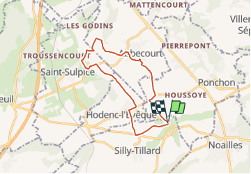
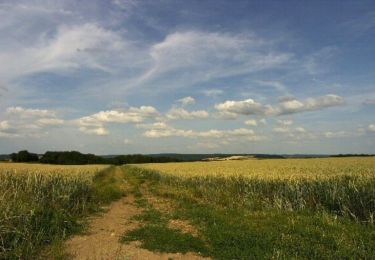
Trail Walking of 11.7 km to be discovered at Hauts-de-France, Oise, Silly-Tillard. This trail is proposed by fitz2014.

Description

L'oise à pied

Elevation profile

Photos

Points of interest

Point of interest Silly-Tillard - Randonnée Abbecourt - Tillard - Photo
fitz2014

Positioning

Country:
France
Region :
Hauts-de-France
Department/Province :
Oise
Municipality :
Silly-Tillard
Location:
Unknown
Start:(UTM)
439826 ; 5464936 (31U) N.

Comments

Please log in to post a review or rate the element


Trails nearby

Trail sport Sainte-Geneviève - DIFF95 - Transoise 2019 - Photo
sport
celinem2773

sport

Very easy
(1)
Sainte-Geneviève, Hauts-de-France, Oise, France
123 km | 152 km-effort
Unknown
Yes
Trail 4x4 Sainte-Geneviève - Reçu 60 - Photo
4x4
celinem2773

4x4

Sainte-Geneviève, Hauts-de-France, Oise, France
130 km | 160 km-effort
9h 35min
Yes
Trail Mountain bike Silly-Tillard - La Gauloisienne 2013  (boucle noire) - Laboissière-en-Thelle - Photo
Mountain bike
tracegps

Mountain bike

Medium
Silly-Tillard, Hauts-de-France, Oise, France
18.8 km | 23 km-effort
1h 19min
Yes
Trail Mountain bike Silly-Tillard - La Gauloisienne 2013  (boucle rouge)- Laboissière-en-Thelle  - Photo
Mountain bike
tracegps

Mountain bike

Medium
Silly-Tillard, Hauts-de-France, Oise, France
15 km | 19 km-effort
1h 10min
Yes
Trail Mountain bike Silly-Tillard - La Gauloisienne 2013 - boucle bleue - Laboissière-en-Thelle - Photo
Mountain bike
tracegps

Mountain bike

Medium
Silly-Tillard, Hauts-de-France, Oise, France
14.9 km | 18.3 km-effort
1h 0min
Yes
Trail Walking Silly-Tillard - Randonnée Abbecourt - Tillard - Photo
Walking
tracegps

Walking

Medium
Silly-Tillard, Hauts-de-France, Oise, France
11.7 km | 14.2 km-effort
2h 55min
Yes
Trail Walking Ponchon - Randonnée Ponchon - Villers St Sépulcre - Photo
Walking
tracegps

Walking

Medium
Ponchon, Hauts-de-France, Oise, France
9.5 km | 11.6 km-effort
2h 25min
Yes
Trail Walking Silly-Tillard - Randonnée de Silly-Tillard - Photo
Walking
tracegps

Walking

Difficult
(1)
Silly-Tillard, Hauts-de-France, Oise, France
12.8 km | 15.4 km-effort
3h 10min
Yes
Trail Horseback riding Sainte-Geneviève - Balade toasty 22 mai  - Photo
Horseback riding
000424.06c930db02a7496ab9c7449d1e5fd4cc.1630

Horseback riding

Easy
Sainte-Geneviève, Hauts-de-France, Oise, France
11.2 km | 13 km-effort
1h 49min
Yes


Close
My subscriptions