![](/images/other/stat-length.png)
![Trail Walking Alquézar - 2017_Camping-Alquezar-Villacantal - Photo](https://media.geolcdn.com/t/1900/400/ext.pjpeg?maxdim=2&url=https%3A%2F%2Fservices.sitytrail.com%2FGeolivesWS%2FDownloadMedia.ashx%3FTrailID%3D801975%26Media%3Dfix__20170803171109.jpg)
2017_Camping-Alquezar-Villacantal
yamty35
User
![Length](/images/other/stat-length.png)
Length
12.7 km
![Max alt](https://static1.geolcdn.com/siteimages/upload/files/1508320355ic_sort_altitude_max_24dp.png)
Max alt
685 m
![Uphill gradient](https://static1.geolcdn.com/siteimages/upload/files/1508320355ic_sort_den_pos_24dp.png)
Uphill gradient
500 m
![Km-Effort](/images/other/stat-length.png)
Km-Effort
19.4 km
![Min alt](https://static1.geolcdn.com/siteimages/upload/files/1508320355ic_sort_altitude_min_24dp.png)
Min alt
460 m
![Downhill gradient](https://static1.geolcdn.com/siteimages/upload/files/1508320355ic_sort_den_neg_24dp.png)
Downhill gradient
501 m
![Boucle](https://static1.geolcdn.com/siteimages/upload/files/16400158638029165_repeat_loop_refresh_sync_direction_icon.png)
Boucle
Yes
Creation date :
2017-08-09 00:00:00.0
Updated on :
2017-08-09 00:00:00.0
![Walking](https://static1.geolcdn.com/sitytour/trail-icons/101.png)
4h07
Difficulty : Medium
![Scan this QR Code to open this trail in the SityTrail application](https://capi.geolives.com/qq0zvz2zws4bq2lad0pu/sitytour/trails/801975/qr.png?size=200)
FREE GPS app for hiking
About
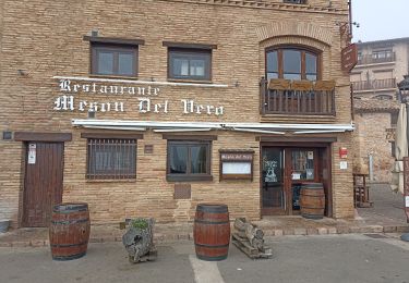
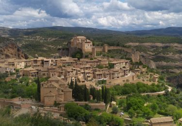
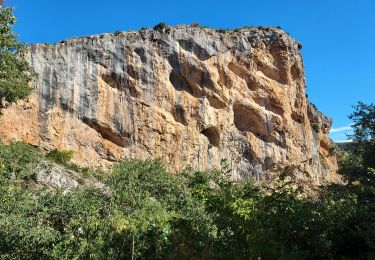
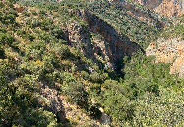
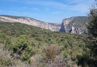
Trail Walking of 12.7 km to be discovered at Aragon, Huesca, Alquézar. This trail is proposed by yamty35.
Description
Rando du camping Rio-Vero jusqu'au pont de Villacantal en passant par Alquezar ; il est possible de rester le long du rio (de l'eau jusqu'à la poitrine)
Positioning
Country:
Spain
Region :
Aragon
Department/Province :
Huesca
Municipality :
Alquézar
Location:
Unknown
Start:(Dec)
Start:(UTM)
254433 ; 4670962 (31T) N.
Comments
Trails nearby
![Trail Other activity Alquézar - Pasarelas Alquezar - Photo](https://media.geolcdn.com/t/375/260/ext.jpg?maxdim=2&url=https%3A%2F%2Fstatic1.geolcdn.com%2Fsiteimages%2Fupload%2Ffiles%2F1545311037marcheuse_200dpi.jpg)
![Other activity Other activity](https://static1.geolcdn.com/sitytour/trail-icons/900.png)
Pasarelas Alquezar
Other activity
Easy
(1)
Alquézar,
Aragon,
Huesca,
Spain
![](/images/other/stat-length.png)
4 km | 6.7 km-effort
2h 28min
![](https://static1.geolcdn.com/siteimages/upload/files/16400158638029165_repeat_loop_refresh_sync_direction_icon.png)
Yes
![Trail Walking Alquézar - ballade dans la Sierra de Guara - Photo](https://media.geolcdn.com/t/375/260/838bc569-651e-4451-ac2a-037e1f493bc0.jpg&format=jpg&maxdim=2)
![Walking Walking](https://static1.geolcdn.com/sitytour/trail-icons/101.png)
ballade dans la Sierra de Guara
Walking
Very easy
Alquézar,
Aragon,
Huesca,
Spain
![](/images/other/stat-length.png)
9.8 km | 13.7 km-effort
2h 26min
![](https://static1.geolcdn.com/siteimages/upload/files/16400158638029165_repeat_loop_refresh_sync_direction_icon.png)
No
![Trail Walking Alquézar - ALQUEZAR boucle par passerelles et abrigo de regacens - Photo](https://media.geolcdn.com/t/375/260/6001d58c-f07f-452f-a78b-31c65d037405.jpg&format=jpg&maxdim=2)
![Walking Walking](https://static1.geolcdn.com/sitytour/trail-icons/101.png)
ALQUEZAR boucle par passerelles et abrigo de regacens
Walking
Difficult
Alquézar,
Aragon,
Huesca,
Spain
![](/images/other/stat-length.png)
11.5 km | 18.1 km-effort
4h 6min
![](https://static1.geolcdn.com/siteimages/upload/files/16400158638029165_repeat_loop_refresh_sync_direction_icon.png)
Yes
![Trail Walking Alquézar - Alquezar,les passerelles du Rio Vero - Photo](https://media.geolcdn.com/t/375/260/ea39bf79-2ea4-4aaf-8ed2-9777aff26f94.jpg&format=jpg&maxdim=2)
![Walking Walking](https://static1.geolcdn.com/sitytour/trail-icons/101.png)
Alquezar,les passerelles du Rio Vero
Walking
Medium
Alquézar,
Aragon,
Huesca,
Spain
![](/images/other/stat-length.png)
3.7 km | 6.1 km-effort
3h 8min
![](https://static1.geolcdn.com/siteimages/upload/files/16400158638029165_repeat_loop_refresh_sync_direction_icon.png)
Yes
![Trail On foot Alquézar - Sierra de Guara - De Alquézar à Asque - Photo](https://media.geolcdn.com/t/375/260/08bb7b6c-9de7-4d1b-8785-6ab6242e5b0d.jpg&format=jpg&maxdim=2)
![On foot On foot](https://static1.geolcdn.com/sitytour/trail-icons/100.png)
Sierra de Guara - De Alquézar à Asque
On foot
Medium
Alquézar,
Aragon,
Huesca,
Spain
![](/images/other/stat-length.png)
9.5 km | 14.5 km-effort
Unknown
![](https://static1.geolcdn.com/siteimages/upload/files/16400158638029165_repeat_loop_refresh_sync_direction_icon.png)
Yes
![Trail sport Alquézar - 2024 08 06_Alquézar - Asque - Photo](https://media.geolcdn.com/t/375/260/6f67a56f-341d-4df6-ac04-5942bbc672c2.jpg&format=jpg&maxdim=2)
2024 08 06_Alquézar - Asque
sport
Very easy
Alquézar,
Aragon,
Huesca,
Spain
![](/images/other/stat-length.png)
12 km | 17.8 km-effort
Unknown
![](https://static1.geolcdn.com/siteimages/upload/files/16400158638029165_repeat_loop_refresh_sync_direction_icon.png)
Yes
![Trail Walking Alquézar - Alquezar - Photo](https://media.geolcdn.com/t/375/260/77611482-3652-4543-86fd-137bc168f78d.jpg&format=jpg&maxdim=2)
![Walking Walking](https://static1.geolcdn.com/sitytour/trail-icons/101.png)
![Trail Walking Alquézar - Alquezar 230311 - Photo](https://media.geolcdn.com/t/375/260/43b1102b-67f8-4437-bc89-4692450ef8e0.jpg&format=jpg&maxdim=2)
![Walking Walking](https://static1.geolcdn.com/sitytour/trail-icons/101.png)
Alquezar 230311
Walking
Very difficult
Alquézar,
Aragon,
Huesca,
Spain
![](/images/other/stat-length.png)
14.7 km | 23 km-effort
7h 3min
![](https://static1.geolcdn.com/siteimages/upload/files/16400158638029165_repeat_loop_refresh_sync_direction_icon.png)
Yes
![Trail Walking Colungo - El portal de cunada, Comongo, 230312 - Photo](https://media.geolcdn.com/t/375/260/ext.jpg?maxdim=2&url=https%3A%2F%2Fstatic1.geolcdn.com%2Fsiteimages%2Fupload%2Ffiles%2F1553511878bg_sport_marche.png)
![Walking Walking](https://static1.geolcdn.com/sitytour/trail-icons/101.png)
El portal de cunada, Comongo, 230312
Walking
Easy
Colungo,
Aragon,
Huesca,
Spain
![](/images/other/stat-length.png)
13 km | 20 km-effort
5h 40min
![](https://static1.geolcdn.com/siteimages/upload/files/16400158638029165_repeat_loop_refresh_sync_direction_icon.png)
Yes